 | The Xenophile Historian |

 |
 |
 |
 |
 |
 |
 |
 |
 |
 |
 |
 |
 |
 |
 |
 |
 |
 |
 |
 |
 |
 |
 |
 |
 |
 |
 |
 |
 |
 |
 |
 |
 |
 |
 |
 |
 |
 |
 |
 |
 |
 |
 |
 |
 |
 |
 |
 |
 |
 |
 |
 |
 |
 |
A History of Africa
Chapter 5: THE TRADING KINGDOMS
641 to 1415
(All dates are A.D. from now on)
This chapter covers the following topics:
The Sword of Islam
Whereas Christianity expanded quietly during the first two centuries of its existence, generating little attention outside of the occasional miracle or martyrdom, Islam burst onto the world scene suddenly and violently; its first missionaries were Bedouin warriors. In the ten years before his death in 632 A.D., Mohammed brought most of the Arabian peninsula under his political and religious authority. Then his successors, the Caliphs, went forth to conquer the rest of the world. In the past few people cared much about what happened in Arabia, even if they lived nearby; now the Bedouins stormed forth and overwhelmed all opponents with amazing speed. By 651 they had demolished the Persian Empire, and conquered all of the Middle East except Asia Minor. Details about Islam's first years may be read in Chapter 9 of my Near Eastern history.
Islam entered the African scene with an invasion of Egypt in 640. Amr ibn el-As, the Arab commander, met no resistance except in Alexandria, and the Romans (called the Byzantines by historians after this) evacuated that great city in 642. You can read Chapter 9 of The Genesis Chronicles to find out what happened to Alexandria's great library.(1) Nor did the Arabs stop there. Almost immediately they raided the Nubian kingdoms to the south, and in 652 an expedition briefly captured Dongola (modern Dunqulah), the capital of Makuria, and destroyed its cathedral. However, the Nubians resisted fiercely and the Arabs had no wish to hold a poor country under those circumstances, so both sides agreed to a peace treaty, which stipulated that the Nubians would supply four hundred slaves every year, and get food and cloth in return. For the Arabs, Nubia was their first setback, if not an outright defeat. To the west, they took Cyrenaica in 642, and Tripolitania in 644; in 647 they began to raid Tunisia.
Tunisia and the rest of the Maghreb proved to be tougher, not because of the Byzantine-held cities, but because of the Berber tribes in the interior. Here the Arabs found an opponent comparable to themselves; the Berbers were not disgruntled subjects of a distant authority, the way the Egyptians were, but as fiercely independent as the Arabs, equally hardy in the desert, and just as skillful in warfare. They had never been completely subdued by the Romans or anybody else, and their communities were a mixture of pagans, Christians and Jews(2), so they saw no need to bow to a religion whose name means "Submission!" The Arabs had to halt their advance on the Libyan frontier for a generation, to save their resources for battles fought elsewhere.
When the Arabs were ready to move again in North Africa, the campaign began with a spectacular success, and ended with a spectacular failure. In 670 they founded Kairouan in central Tunisia, as an advance military base; soon it would become the Maghreb's most important city. From here in 681, Uqba ibn Nafi, the nephew of Amr ibn el-As, led a new army west. He advanced all the way to Morocco, captured Tangiers, and then followed the Atlantic coast as far as Agadir. There Uqba turned back, but before doing so, according to the story, he rode his horse into the ocean and shouted, "Allahu akbar! If my course were not stopped by this sea, I would still ride on to the unknown kingdoms of the west, preaching the unity of Allah, and putting to the sword the rebellious nations who worship any other god but him!" However, this was not a conquest so much as a raid, because Uqba couldn't hold on to any captured territory. As the Arabs withdrew, the Berbers began to pursue, and near Biskra in eastern Algeria, a chief named Kusaila fell upon and killed them all, including Uqba (the battle of Tehuda, 683). Then other tribes joined Kusaila's and together they retook the coastal cities, forcing the Arabs back to Kairouan.
Another Arab army left Egypt in 694, led by Hassan ibn Numan. He killed Kusaila, captured and destroyed Carthage in 698, and expected an easy sweep westward from there. What he got instead was organized opposition, now led by a Berber queen named Dihya al-Kahina. Unfortunately we don't have much concrete information about her; the one thing we can be sure of is that she was Jewish (Kahina being a local form of Cohen or Cohanim). Jewish legends go on to portray her as a medieval version of the prophetess Deborah, while Arab writers like Ibn Khaldun claimed that she was a sorceress, who lived to the age of 127. At any rate, Kahina did not confront the Arabs directly, but took the Byzantine city of Bagia first, roused its population to join her, and then when the Arab army arrived, sneaked out of the city through secret passageways and attacked the besieging force in the rear. As the townspeople of Bagia charged out the city gates to join in the attack, the Arabs were completely routed. Hassan and a fraction of his 40,000-man force barely made it to Gabes, whereupon they escaped to Egypt.
Five years of peace followed, until the Caliph assigned a fresh army of 60,000 troops to Hassan. This time he used diplomacy and propaganda to divide the Berbers. He promised autonomy to the North African Christians, playing on their fear of both the Jews and the possibility of a Visigoth invasion from Europe. To the Jews, he proposed that he and Queen Kahina join together in an invasion of the Iberian peninsula, to liberate Spanish Jews from Visigoth rule. Consequently, when Hassan's army crossed the border again, it advanced without resistance and was even supported by the Christian communities it passed. In desperation, the queen launched a "scorched earth" campaign to destroy cities, farms and orchards, arguing that the Arabs would go home if there was nothing left for them to take. But that only served to alienate her Greek and Latin-speaking subjects, who lived in the ravaged areas. When the final showdown took place at the ancient Roman amphitheater of El Jern, Tunisia (705), Queen Kahina and her Berbers went down fighting, after a furious battle. Hassan sent her head back to the Caliph, and gave all Berbers and North African Jews this choice: Islam or death. About 50,000 refused to convert and were massacred, while the rest accepted Islam. It took until 708 for an Arab force to reach Morocco (Maghreb al-Aqsa, meaning the Far West, in Arabic), but after 705 all of North Africa was part of the Islamic world.
This marked the end of the game for North African Christianity. While in Egypt it managed to survive as the faith of a minority, in the Maghreb the Church dwindled to nothing. By 1050 the land could only support three bishops, compared with more than three hundred in late Roman times; by 1200 there weren't any bishops left. The Berbers proved to be enthusiastic converts to Islam, even more so than the Arabs. Thanks to them, North Africa would never again be merely the southern shore of European/Mediterranean civilization, and they remained Moslem even after the French conquered them in the 19th and early 20th centuries. They also led the way in the next phase of Islamic expansion--into Europe.
Before long the new Berber general, Tariq ibn Ziyad, was invited to attack Spain. On the coast was one city that hadn't been taken yet, Ceuta. Officially Ceuta was a Byzantine outpost, but because Constantinople was so far away, its leaders had been relying on the Visigoths for protection since 618. However, Roderick, the Visigoth king, had raped the daughter of Count Julian, the current leader of Ceuta, and Count Julian was understandably enraged about this. He subsequently wrote to Tariq, offering to switch his allegiance to the Moslems and to provide the ships necessary to cross over to Spain. Tariq and his superiors were nervous about trusting a Christian, so in 710 they put Julian to the test, letting him first transport a raiding party of 400 men. The raid was a success, so one year later Tariq led 7,000 men across. His first headquarters in the new land was on a mountain previously known as one of the Pillars of Hercules, but since that time it has been called Gibraltar, from the Arabic Jebel al-Tariq (Tariq's Mountain).
Roderick assembled his army and hurried south to deal with this threat. By the time he got there, 5,000 more troops had arrived as reinforcements for Tariq. The resulting battle took place at Laguna de Janda, between Seville and Cordova, on July 19, 711; Roderick was defeated, and either slain or drowned while attempting to escape. Instantly the Visigoth kingdom disintegrated, and the Moslems overran the rest of Spain and Portugal effortlessly. Then they continued into France, not stopping until they were defeated by Charles Martel near Tours, just 100 miles short of Paris (732).
In East Africa, the Abyssinians had supported Mohammed at first, giving asylum to his followers while the pagans of Mecca were the common enemy. That changed when Islam prevailed and began conquering lands that had previously been Christian. Abyssinian pirates raided Arab shipping in the Red Sea, even sacking Jiddah, the port of Mecca, in 702. However, the Arabs had a navy of their own by this time, and they retaliated by capturing and converting Eritrea. Abyssinia survived, but now it was landlocked and confined to the mountains, its days as a regional power finished. And because Egypt was in Moslem hands, Abyssinia and the three Christian Nubian states were cut off from the rest of Christendom, soon to be forgotten by their brethren in Europe and Asia Minor.(3)
Around the end of the seventh century, one of those Nubian states, Nobatia, disappeared. Details are not available, but Nobatia and Makuria both ended up under the rule of Dongola, and its king, Merkurios (697-707?). The most obvious guess is that Makuria annexed Nobatia, but afterwards everybody in the united kingdom followed the Monophysitism of Nobatia, not the Orthodoxy of Makuria. It is unusual, though not unheard of, for a conqueror to adopt the religion of the conquered.
![]()
The Settlement of Madagascar
The human race settled the continental portions of Africa, Asia and Europe before it settled most of the world's islands, and it is easy to understand why; you need some sort of water craft to get to the islands. Madagascar was settled relatively late in history, by the boldest sailors of the ancient world. These were the Malayo-Polynesians, who crossed the Pacific by trusting in things of nature like birds, ocean currents and stars to guide them.
Regarding how Madagascar got started, most history texts will tell you that at an uncertain date between 1 and 500 A.D., one or more outrigger canoes left Southeast Asia, crossed the Indian Ocean and landed on Madagascar. They brought with them several valuable crops, introducing them to Africa: rice, mung beans, taro, bananas, plantains, coconuts and sugar cane. That was all that could be said on the subject until the twenty-first century, when language and DNA analysis entered the picture. We now believe these Malays launched their boats from Borneo, because the language and DNA of the Malagasy most resembles that of Borneo's southeastern tribes. A recent comparison of mitochrondrial DNA samples from 266 modern Malagasy indicated that they were descended from just thirty women. Because the trading vessels of Indonesian kingdoms like Srivijaya could carry up to 500 people, this means only one boatload of Indonesians was needed to colonize Madagascar. Of course the boat must have also carried men, and there could have been some women who did not have any children, but because mitochondrial DNA is inherited only from the mother, evidence for them will not show up in such tests. The tests also suggested that the settlers arrived much later than expected, most likely around 830 A.D.
With navigation being what it was in those days, it is unlikely the settlers knew where they were headed; they may have been blown off course, and decided it was safer to keep going than to try returning. Or they could have been refugees, fleeing after Srivijaya conquered their homeland. After 1000 A.D., their descendants did some trading with the mainland, and some Bantus came to Madagascar, so today's Malagasy are half Asian and half Black African.(4)
![]()
Across the Burning Sands
The Moslem conquest of Spain coincided with a missionary effort to convert the Berber tribes of the deep Sahara, the Tuareg. It didn't get as much attention because no battles were fought, nothing exciting happened, and because the process stretched out over the whole eighth and ninth centuries. Even so, the advance to the south was arguably more important than the one to the north, for while the Moslems were eventually ejected from Spain, the consequences of their African activities are still with us today. The conversion of the Tuareg opened pathways across the desert to West Africa, or as the Arabs called it, Bilal as-Sudan ("the Land of the Blacks").(5) Around 850, the Tukulor of Senegal became the first black tribe to accept Islam.
Camels made the Sahara crossing possible. This thoroughly useful animal was first introduced to Africa when the Persians conquered Egypt in the sixth century B.C. We hear about them in the Maghreb from the first century B.C. onwards, but not until now did any Africans use them the way the Arabs did. Apparently they had trouble getting a large enough herd together to breed a self-sustaining population.(6)
Any map of Africa will show you that it would have been a simple matter to go around the desert instead of going through it; just sail down the Atlantic coast from Morocco to Senegal, and you would have made contact with the West Africans. The Portuguese showed how easy this was in the fifteenth century (see Chapter 6), and the Arabs had a perfectly good navy by the end of the seventh century, but they--and the Berbers--had the desert life so burned into their minds that they didn't think of traveling by sea. They didn't even visit the Canary Islands, the existence of which was forgotten when the Romans lost control of Morocco.
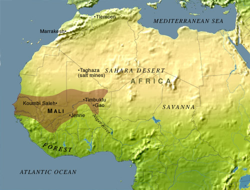
As they blazed trails through the Sahara, the nomads set up caravan towns at the beginning and end of the new routes. The towns in the north were located either in the Atlas mts. or at oases in the nearest part of the desert: Sijilmasa in Morocco, Wargla in Algeria, and Ghadames in Libya. Merchants coming from the Mediterranean coast would transport their cargoes on donkeys at first, and then when they reached these desert "ports," they transferred them to camels for the trans-Sahara journey. On the opposite shore of this sea of dunes stood another series of "ports": Awdaghost and Walata in Mauritania, Timbuktu and Gao in Mali, and Takedda in Niger. Here the merchandise was shifted back to donkeys, or if the final destination was in the jungles beyond the Sahel, human porters might carry the loads. The most popular commodities were European and Arab manufactured goods for the trip south, and hides, kola nuts(7) and gold for caravans heading north.
Camel drivers made their biggest profits on the Sijilmasa-Awdaghost run. This trade route passed through a part of the western desert that contained salt deposits, always a valuable commodity in hot climates. The salt was dug out of the ground or gathered from evaporating pools of water, taken to Awdaghost, and exchanged for an equivalent weight of gold, which more than covered the high cost of desert transportation.(8) Awdaghost was also the closest terminus to Ghana, West Africa's first important kingdom.
![]()
The Rise of Ghana
The first outsider to mention Ghana, the kingdom of the Soninke tribe, was an Arab geographer named al-Fazari, writing in the court records of Baghdad in 773. However, the name is confusing for more than one reason. First, the natives called it Wagadu.(9) The king's title was Ghana, and people gradually switched from calling this place "the kingdom of the Ghana" to simply Ghana, much like how the name of a South American king, the Inca, eventually became the name of his people. Second, the kingdom was located on the north bank of the Senegal and Niger Rivers, in what is now southeast Mauritania and southwest Mali, approximately five hundred miles northwest of the modern nation of Ghana. Present-day Ghana also has a claim to a glamorous past, as the home of the Ashanti people, but that's a story we'll cover in the next chapter.
Third, foreigners called Ghana "the Land of Gold," though the gold always came from outside the kingdom's boundaries. The main source of gold at this time was the Bambuk field, south of the upper Senegal River. When Ghana tried to rule this area directly, gold production plummeted, so the kingdom chose instead to tax everyone going to and from Bambuk. Since everyone heading northward from Bambuk had to pass through Ghana, this gave the kingdom an effective gold monopoly. Around 970, Ghana conquered Awdaghost, giving it control over the trade route from the north, too.
Historians used to believe that the Arabs brought civilization to Ghana and the rest of West Africa, but recent discoveries like Jenné-Jeno now tell us that the Arabs merely finished the job, by introducing Islam and the Arabic alphabet. The political evolution, from tribe to city-state to confederation to centralized kingdom, most likely took place in the fifth or sixth century, quite some time before the first trans-Saharan contact. Local traditions identify the founder of Ghana as a leader named Dinga Cisse, and they assert that he was an outsider, not a member of the tribe, but disagree on why he built the kingdom.(10)
Ghana set the standard by which all future kingdoms of the Sahel would be organized: an absolute monarchy, an emphasis on trade and wealth, at least partial acceptance of Islam, etc. Foreigners and subjects alike saw plenty of pomp in the royal court. A log drum called a daba was beaten to signal that those in the audience had permission to approach the king, and those who presented themselves fell on their knees and sprinkled dust on their heads as a sign of respect. And there was much more, also designed to impress everyone:
"The King adorns himself like a woman wearing necklaces round his neck and bracelets on his forearms and he puts on a high cap decorated with gold and wrapped in a turban of fine cotton. He holds an audience in a domed pavilion around which stand ten horses covered with gold-embroidered materials. Behind the king stand ten pages holding shields and gold-mounted swords; and on his right, are the sons of the vassal kings of his country, wearing splendid garments and their hair plaited with gold. At the door of the pavilion are dogs of excellent pedigree. Round their necks they wear collars of gold and silver, studded with a number of balls of the same metals."(11)
Al-Bakri, the author of the previous quote, also reported that the king of Ghana could call up 200,000 soldiers, including 40,000 archers; compare this with the 7,000 men William the Conqueror had at the battle of Hastings! The capital was a double city, which we believe was at Kumbi Saleh, in southeast Mauritania. The original town had traditional houses surrounded by a palisade, and the burial mounds of deceased kings, while the newer merchant town stood six miles away. The merchant town had a population that was mostly Moslem, judging from the twelve mosques it contained. French archaeologists excavated the merchant town from the 1950s to the 1970s, and estimate that at its peak, it had as many as 20,000 residents. However, the royal city has not yet been located. Perhaps it wasn't rebuilt after the Almoravids destroyed it in 1076 (see below), due to its pagan origins.
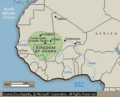
Ghana, about 1000 A.D.
![]()
Islam Divided
The most bitterly contested political issue in the Islamic world was over who was qualified to rule as Caliph. At first the Caliphs were handpicked, but in 661 the succession became hereditary, with all candidates coming from the Umayyad family. However, this didn't satisfy everybody, especially the Shi'a (partisan) faction, which believed that the Caliph must be directly descended from Mohammed's daughter Fatima and her husband Ali.
The Umayyads governed from Damascus, rather than from Arabia. They were in turn overthrown in 750, but their enemies could only cooperate long enough to massacre every Umayyad they could get their hands on. The new rulers, the Abbasids, weren't interested in playing to the tune of the Shiites, so even while a new capital for the Caliph was being built at Baghdad, the Islamic empire began to break up. And once Moslems stopped believing that there was only one rightful ruler, a tendency toward anarchy took over, especially among those who had been nomads previously--the Arabs and the Berbers. As a result, most governments in the Islamic world after 750 were less stable than their counterparts elsewhere; they rose and fell with unsurprising regularity, with religion, rather than politics, acting as the glue that kept Moslems believing in a brotherhood of man. Ibn Khaldun, the great North African historian of the fourteenth century, explained it this way:
"The reason for this is that because of their savagery, the Bedouins are the least willing of nations to subordinate themselves to each other, as they are rude, proud, ambitious, and eager to be the leaders. Their individual aspirations rarely coincide. But when there is religion (among them) through prophethood or sainthood, then they have some restraining influence in themselves. The qualities of haughtiness and jealousy leave them. It is, then, easy for them to subordinate themselves and to unite (as a social organization)."(12)
Because the Caliphs had relocated to the east, connections with the western provinces were lost first. In 756 a fugitive Umayyad made it to Spain and declared the Iberian peninsula an independent state, which would later be called the Caliphate of Cordova. Then in 772 Midrar, a Berber who followed the extremist Kharijite sect, revolted against the Abbasid governor of Kairouan, establishing the Midrarid Emirate at Sijilmasa in Morocco. Five years later another group of Kharijite Berbers seized Tahert in Algeria, founding the Rustamid Emirate. The rest of Morocco went next; Idris I, a great-great-grandson of Fatima, fled Arabia, settled in Morocco, and declared himself a Shiite Caliph, not recognizing in any way the authority of Harun al-Rashid, the current Abbasid Caliph (789). Idris was assassinated by an agent of Harun al-Rashid in 793, but the Idrisid dynasty survived under his son, Idris II, who subsequently built a new capital at Fez.
Other parts of North Africa left more quietly. The Aghlabids (Tunisia, 800) and the Tulunids (Egypt, 868) both came from Baghdad as appointed governors; they made sure that members of their families would inherit those jobs, and drifted into independence without much fanfare. They still acknowledged Baghdad as the ultimate religious authority, so their rulers styled themselves emirs (princes), rather than taking the higher-ranked title of Caliph. Libya was divided between them, with Tripolitania going to the Aghlabids, and Cyrenaica to the Tulunids. In 836, the Nubian kingdom of Makuria stopped sending slaves to Egypt, as stated in the 652 treaty, though it was willing to sell slaves if the Arabs were interested.
It is also worth noting that Islam continued to expand despite the end of unity, only this time the breakaway states did the conquering; Spanish Moslems took the Balearic Islands, starting with Ibiza in 798, and they took Crete in 823, while the Aghlabids invaded Sicily in 827; both made regular raids on the Mediterranean coasts of France and Italy. In 905 the Abbasids regained control of Egypt, only to lose it again thirty years later, to the short-lived Ikhshidid dynasty (935-969).
![]()
Nigerian Surprises
In Chapter 4, we looked at Nigeria's first step toward civilization, the Nok culture. Several centuries later, an unknown tribe living nearby left us a surprise. At Igbo Ukwu, a village 25 miles east of the apex of the Niger River's delta, Isaiah Anozie dug a water cistern in the courtyard of his home in 1939. Two feet down, his hoe struck a hard object, which turned out to be a green bronze pot, chased with insects and small animals. After removing it, he kept digging, and eventually found forty more wonderfully crafted objects. He gave most of them away, and twenty years later they attracted the attention of Nigeria's Federal Department of antiquities. When an archaeologist, British-born Thurstan Shaw, arrived at Igbo Ukwu in November 1959, he learned that Anozie's brother Richard had dug up bronzes on his own property, so he had two sites to excavate, appropriately named Igbo Isaiah and Igbo Richard. Over the next four months, he uncovered many more objects, the most spectacular being a bronze pot surrounded by cords, and a foot-long bronze replica of a triton shell, both found at Igbo Isaiah. These are the oldest bronze artifacts ever found in sub-Saharan Africa.
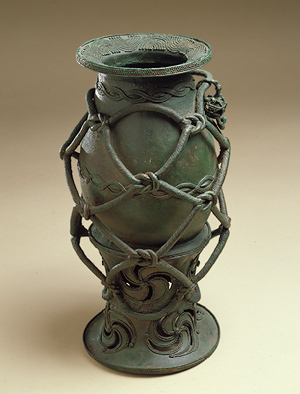
The corded bronze pot. This work was first cast in several pieces, using the "lost wax" process (see
Chapter 4, footnote #19), and then welded together to form the finished masterpiece. From Metmuseum.org.
The placement of artifacts at Igbo Richard explained how they got into the ground in the first place. With the bronzes found there were glass beads, ivory tusks, a copper crown and bangles, iron nails, wooden fragments--and human skeletons. Shaw concluded that an important person--a king, chief or high priest--had been buried sitting on a throne, surrounded with valuables and enclosed in a vault lined with wood. On top of the vault were five more skeletons, but we can't tell if they were willing or unwilling sacrificial victims. A carbon-14 test of a wood sample revealed an age much older than expected; these graves were dug in the ninth century A.D.
The copper used to make the bronze works came from a copper and lead mine, 50 miles west of Igbo Ukwu. Igbo bronzes have a high silver content, so we are confident that the early Nigerian smiths taught themselves metallurgy; if they had learned it from Europeans or North Africans, they would have taken the silver out, the way other smiths did. Alas, we may never know who did this fine craftsmanship, and whether they are related to the Igbo tribe currently living in the region.
Across the Niger River, the city-state of Ife was getting started around the same time. The founders of Ife were the Yoruba, one of the three dominant tribes in modern Nigeria (the others are the Igbo and the Hausa), and Ife was the oldest of the "forest kingdoms" that figure so prominently in the period covered in the next chapter. None of the forest kingdoms would be as large as the states of the Sahel, due to the difficulties of transportation in a jungle environment, but they made up for it in cultural brilliance.
Ife was settled as early as 600 A.D., and saw its glory days from about 850 to the early sixteenth century, when it was overshadowed by Oyo, a more powerful Yoruba kingdom. One Yoruba legend claimed that the first king of Ife was the god Oduduwa, and his sixteen sons founded the other Yoruba states, so Ife was regarded as a holy city. From the start, Ife produced sculptures of people's heads. These were originally terra cotta works, like the Nok sculptures, but in the eleventh century artists began making them out of copper, brass and bronze as well. Presumably these were attached to wooden bodies, and because of their regal appearance, we believe they were memorials to kings and queens; some of them wore crowns. Some are highly stylized, while others (see the picture below) are strikingly realistic, showing even the facial scarring that was commonly practiced as a rite of initiation. Leo Frobenius, the German who discovered these works in 1910, was so impressed that he thought he had found the lost country of Atlantis in Africa, and that one of the statues was a representation of the Greek god Poseidon. He wrote that here was "a symmetry, a delicacy of form directly reminiscent of ancient Greece."
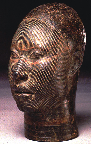
This stunningly naturalistic brass head was made at Ife in the thirteenth century, to represent an unknown king. The holes above the eyebrows suggest that it originally wore a crown or headband, while the vertical lines represent ritual facial scarring. Click on the thumbnail for a full-sized picture (opens in a new window).
Just as we now believe that the Ife artists learned their skills from their Nok predecessors (though an intermediate culture between Nok and Ife has not yet been found), so the most brilliant forest kingdom of all, Benin, would become a cultural heir to Ife. We will come back to this region in the next chapter of this work, when we cover Benin's accomplishments.
![]()
The Cities of the Messiah and the Conqueror
Among the Shiites, the Ismailis stood out as a particularly militant bunch. Like other Shiites, they look forward to a descendant of Fatima and Ali coming as a messiah, whom they call the Mahdi. What makes the Ismailis different is their liberal interpretation of scripture; they expect the Mahdi to be the greatest prophet of all, greater than even Mohammed, and that he might be alive now, as their current leader. The ninth century saw Ismaili missionaries go throughout the Islamic world, where they set up secret societies dedicated to undoing the error that had put Sunni (orthodox) Moslems on the Caliphal throne. In 893 the Ismaili grand master, Said ibn Husayn, sent Dai Abu Abdullah al-Shii to North Africa, where he went to work converting Berbers to the cause.
By 902, al-Shii had enough followers to launch a rebellion against the Aghlabid rulers of Tunisia, east Algeria, Tripolitania and Sicily. Said ibn Husayn sailed from his base in Syria to take charge of the movement, but he acted too hastily; at Tripoli he was arrested and locked up by the Aghlabid governor, until al-Shii overthrew the Aghlabids and the Rustamids in 909. Once free, Said ibn Husayn changed his name to Ubaidallah, declared himself the Mahdi, and proclaimed the establishment of a Fatimid Caliphate. To show he was taking Islam on a new course, he did not make Kairouan his capital, the way the Aghabids had done, but built a new capital in southern Tunisia. Appropriately, it was named Mahdiya, the "City of the Mahdi."
Though most of his subjects were Berbers, the Mahdi remained an Arab at heart; he wanted to return to the Middle East and replace Abbasid rule with his own.(13) Accordingly, he struck east to conquer Egypt in 914, 919 and 925. All three expeditions failed, but because the Fatimids were more vigorous than their opponents, they were successful in other areas. After Ubaidallah's death in 934, they took a leading role in the jihad against Christians in the Mediterranean, taking and briefly holding Malta, Sardinia, Corsica, the Balearics, and Cyprus. In 965 they completed what the Aghlabids had started, by conquering the last part of Byzantine-ruled Sicily. There was even the prospect of an invasion of the Italian mainland, and only a Kharijite rebellion at home in the 940s kept this from happening.
Al-Mu'izz, the fourth Fatimid Caliph (953-975), achieved the goal that had escaped his predecessors, by taking Egypt in 969. He built a new capital there, and named it El Qahira ("The Victorious," we call it Cairo), because an astrologer saw the planet Mars at the time of the founding, and took it as an auspicious sign. Also founded on that spot was al-Azhar, the oldest university still active in today's world. In 973 the Caliph made Cairo his permanent home, leaving the Maghreb to the Zirids, a dynasty of Berber governors. On their own, the Zirids conquered Morocco, crushing the Idrisids in 974 and the Midrarids in 976, so for the first (and only) time since the days of the Roman Empire, all of North Africa was united under one government.
This unity proved to be of the most temporary sort. The Fatimids went on to conquer the Levant (Syria, Lebanon and Israel) and western Arabia, giving them command over more than half of the Islamic world. Their activities in the Middle East--their confrontations with the Turks and Crusaders, the founding of the Druze religion, and the exploits of an Ismaili terrorist group, the Order of Assassins--are topics covered in Chapter 10 and Chapter 11 of my Middle Eastern history. But by concentrating all of their attention eastward, they repeated the mistake of the Abbasids. Indeed, Morocco felt so neglected that it transferred its allegiance to Spain's Umayyad Caliph in 980. In the first decade of the eleventh century, the Umayyads lost control of Spain, and Morocco found itself independent under the Maghrawa Berbers. Then the Hammadids, a branch of the Zirid family in charge of Algeria, broke away in 1014. Finally the Zirid emir of Tunisia declared independence in 1049, renouncing the political authority of the Fatimid Caliph--and even worse, from the Shiite point of view--stating that he now was a Sunni.
The Fatimid response was to turn the Bedouins loose against the Zirids. Around 975 they had relocated two Bedouin tribes, the Banu Sulaym and the Banu Hilal, to Upper Egypt, thereby increasing the Arab component of Egypt's population. Supposedly the Fatimids were always in control, and they had punished the Bedouins for making trouble in Arabia. However, population pressure may have also been a factor, meaning that the Fatimids probably had no more control over these nomad migrations than the last Western Roman emperors had over the barbarians who crossed their borders. Now the Caliph encouraged these tribes to go west; the Banu Sulaym settled in Libya, making that country predominantly Arab. The Banu Hilal attacked in Tunisia and Algeria, sacking Kairouan in 1057 and driving the Zirids and Hammadids into coastal cities like Mahdiya and Bougie. Their occupation of the Maghreb hinterland nearly destroyed the local economy, and North Africa hasn't been the same since.
![]()
Cities of Coral
In the period covered by the last chapter, we saw Phoenicians, Greeks, Indians and Arabs explore the East African coast, for trading purposes. This was the first step in the development of the commerce-minded Swahili culture, which may have begun as early as the first century A.D. The word Swahili means coast-dweller, and the area we're talking about is very long and narrow, running 1,800 miles from Somalia to Mozambique, plus the Comoro Islands and the nearest coast of Madagascar, but only extending a few miles inland, hence the geographical term "the Swahili Corridor," coined by British archaeologist Mark Horton.(14) There never was a Swahili tribe per se, and the coast was never united politically, but the trading network spread Swahili speakers far and wide, making the Swahili language the lingua franca of East Africa.
As with Ghana, we used to believe that the Arabs got East Africa started, by settling and civilizing the region. Archaeological excavations have revealed a different story; beneath the Arab-style domed buildings of medieval Kenya and Tanzania lie older, more traditional structures, made of coral, timber and clay. Thus, it now appears that Africans did most of the work of building their civilization by themselves. As for Arab settlement, only a few Arabs stayed here permanently, and were quickly assimilated into the general population.
Before the tenth century, Chinese and Indian merchants came to East Africa regularly. The Arabs came often enough to justify the building of new ports at Zeila and Berbera, on the part of Somalia facing the Gulf of Aden, but they were reluctant to spend much time in a non-Moslem country. South of the Horn of Africa, they preferred to build their trading posts on offshore islands, to minimize contact with those natives they weren't doing business with. It now appears that among the Swahili, the main motivation to convert to Islam was to encourage more trade with the Middle East, because the ruling elite converted first. They were also attracted because Islam brought writing, a code of ethics and laws, and the opportunity to unite with the rest of human society. The oldest evidence of Islam found so far in East Africa is the remains from eight wooden mosques on Pate Island, off Kenya, dating to 800 A.D. Conversion did increase trade, but it also made the Swahili more vulnerable to the risk that all commercial cultures face--political problems in the country their customers come from. One such problem that hurt business was a major slave uprising in Iraq, the Zanj Rebellion (869-883); the Arabs didn't want to buy any black African slaves for a long time afterwards. Then China's friendly Tang dynasty fell in 907, and it took until the middle of the tenth century to recover from that slump.
Trade with the Arabs increased after 950, and by 1100 they had nine major ports south of the Horn of Africa: Mogadishu and Brava in Somalia; Pate, Malindi and Mombasa in Kenya; Pemba, Zanzibar, Mafia and Kilwa in Tanzania. They also were more willing to build on the mainland, and wherever they did, they made converts more quickly; e.g., thanks to Mogadishu, the Somali tribe was at least 50% Moslem by 1200. The main products that the Arabs bought were the same as in ancient times: slaves, ivory and gold. They also picked up tortoiseshell, spices, iron, tin and copper; most of the metals weren't mined locally, but came from inland sources like Katanga, in the upper Congo basin. In return, the Africans bought cloth and beads, and luxury items like Indian jewels, Chinese porcelain and Thai stoneware.
The most successful port was Kilwa, and its ruins still stand as testimony to the wealth it once enjoyed. When gold was discovered on the Zimbabwe plateau, Kilwa, being the southernmost port, was in the best position to transport and market it, so most of southern Africa's gold passed through Kilwa, until the Europeans appeared on the scene. Among the buildings constructed at Kilwa were a many-domed mosque, first built in the eleventh century and enlarged to four times its original size around 1300, and a clifftop palace called Husuni Kubwa, with more than a hundred rooms; the latter was the largest building sub-Saharan Africa had seen so far. Another interesting feature was the extensive use of coral, which was more readily available on the coast than conventional building materials like granite and limestone.
In the thirteenth century, the Kilwa merchants led the way in building ports farther down the coast, at Mozambique, Quelimane and Sofala, so they could be closer to the source of the gold. Around the same time, or in the early fourteenth century, southbound ships from Kilwa discovered the Comoro Islands and Madagascar. The Comoros had previously been uninhabited, and now a mixed population of Arabs, Malagasy, and Bantus moved there. Arabs gave this whole region a single name, al-Qmr, suggesting that they only saw the northern tip of Madagascar; if they had seen more they would have realized that this huge island belongs in a category by itself.
![]()
The Almoravids and the Almohads
The mid-eleventh century saw nomads on the move everywhere in the Islamic world. In Asia the newly converted Turks expanded west and south from their Central Asian homeland (Turkestan), eventually settling in Turkey. In Africa there were the migrations of the Arabs (already mentioned in the previous section) and the Berbers.
The Berber migration was led by the Sanhaja, the tribe living in Mauritania. Like the Tuaregs of today, Sanhaja men covered their faces with veils, and lived a harsh, disciplined life. Anyway, the ball got rolling with a pilgrimage to Mecca in 1039 by Yahya ibn Ibrahim, chief of the still-pagan Djodala clan. He brought back a Berber theologian, Abdallah ibn Yassin, to teach a purer form of Islam, untainted by local customs. Ibn Yassin also preached a social gospel, which denounced the wealth of Ghana and the Fatimids and declared that everyone's house should be the same height; this appealed especially to the nomads, whose tents were the lowest houses of all. Two years later ibn Ibrahim died, and the Djodala rejected ibn Yassin. He and his followers went to a secret location and built a ribat--a monastery fortified and organized like a military camp. From there they made more converts, and declared a jihad against all non-believing and heretic Sanhaja.(15) They called themselves al-Murabitun (meaning either "Guardians" or "Men of the Monastery"); Christians called them the Almoravids. Whatever the name, their goal was to establish a puritanical political community in which only the laws of Islam (the Shari'a) would be applied.
Over the course of the next decade, the Almoravids attacked all the Berber groups of the western Sahara, including the Djodala, forcing them to submit to Islam and ibn Yassin's authority. Then the united Sanhaja showed their strength--and long reach--by striking on both sides of the desert. They captured Sijilmasa in 1054 and Awdaghost in 1055, thereby gaining control over the salt-for-gold trans-Sahara trade route. Ibn Yassin died in 1059, and leadership of the movement passed to Abu Bakr ibn Unas in the south, and to Yusuf ibn Tashfin in the north. Together they made a fine team; in 1062 they built Marrakesh and made it their capital (Morocco's name is derived from this city). Meanwhile the conquests continued, with hardly an interruption; by 1082 western Algeria was theirs, while in the Sahel they conquered Ghana in 1076, and pushed as far east as Tadmekka by 1083. This means they controlled all of Mauritania, Mali and Morocco, and at least half of Algeria.
An invitation gave the Almoravids an opportunity to add Moslem Spain to their rapidly growing empire. Here the Caliphate of Cordova was only a memory; the Iberian peninsula was now divided between twenty-four Moslem and six Christian states. At first the Christian kings of Galicia, Leon, Castile, Navarre, Aragon and Barcelona felt safer fighting each other than waging the Reconquista against the common enemy, but as they advanced southward, they came to realize that the bad times of the tenth century were over, and as their confidence increased, that of the Moors faded away. Finally in 1085, the Moorish kings called on the Almoravids to save them, and Yusuf ibn Tashfin was glad to oblige. He came over, used his desert warriors to put the Christians back in their place, and then returned to Africa. After his departure the Christians were able to resume their offensive, forcing ibn Tashfin's clients to call him back. This time he decided that the Moslem rulers were too weak, and that he would have to conquer Spain to keep from losing the whole thing to the Christians. Between 1090 and 1093 he deposed Moslem rulers and annexed their realms. The only Moslem territories he couldn't take were the cities of Saragossa, Albarracin, Lerida, and Valencia. Valencia held out because it came under the rule of the famous Christian hero of medieval Spain, El Cid; it finally fell to the Almoravids in 1102, three years after El Cid's death.
Almoravid good fortune petered out following the death of Abu Bakr in 1087 and ibn Tashfin in 1106. Their last victory was the capture of Saragossa in 1110, which united al-Andalus, but then in 1118 Saragossa was lost again, to Navarre. In Spain they were few in number, a small elite over a mixed population of Arabs, Berbers, Jews and Spanish Christians, and consequently didn't do much better than the kinglets they had replaced. Back in North Africa, a revolt broke out in 1130 at Tin Mal in the Atlas mts., involving the Zenata Berbers, arch-enemies of the Sanhaja. Leading the Zenata were the al-Muwahidin, meaning "those who proclaim the unity of God" (better known to us as the Almohads), a fanatical Shiite group that in some ways resembled the Almoravids. They captured Marrakesh in 1147, and the Almoravids fled to Spain; the Almohads pursued, conquering southern Spain between 1150 and 1172. To the east, the Almohads overran Algeria, Tunisia and Tripolitania between 1152 and 1160. After the fall of the Almoravids, the Banu Ghaniya, former viceroys of the Almoravids on the island of Majorca, continued the struggle, sometimes invading the eastern Maghreb, before the Almohads finally deposed them in 1203.
Brutal, intolerant policies couldn't turn the tide in Spain, and when a Christian/Moslem rematch took place, the Almohads fared so badly that they got out of Spain completely (1228-29). Back in Africa their governors declared independence: the Hafsids in Tunisia and Tripolitania (1236) and the Zayyanids in Algeria (1239). One of the Christian states in Spain, Aragon, took advantage of this disunity by seizing Jerba, an island off southern Tunisia, occupying it from 1284 to 1333. The Almohads held onto the last part of their realm (Morocco) until 1269, before being overthrown by another Zenata Berber clan, the Banu Marin (henceforth known as the Marinid dynasty).(16)
This arrangement, with separate governments in Tunisia, Algeria and Morocco, was quite stable, lasting with few changes until the Ottoman Turks arrived, nearly three hundred years later. In fact, one gets the feeling that a three-way division is the most natural one for the Maghreb, because it has happened so many times, as far back as 200 B.C. In 1259 the Hafsids renamed their state the Hafsid Caliphate, not because of any religious zeal, but because the office of Caliph had become vacant, with the extinction of the Abbasid Caliphate a year earlier. The Hafsids fought almost constantly with the Marinids for control of the Zayyanid state between them, while the Marinids made several unsuccessful efforts to recover lost ground in Spain, resulting in the disintegration of that regime when Portugal turned the tables and invaded Morocco (1415).
![]()
Ghana Revisited
West Africans tell a myth about a black snake named Bida to explain what happened to Ghana. This snake gave the kingdom its prosperity, and in return it demanded an annual sacrifice. Thus, a virgin was offered to it every year, until Mamadou Sarolle, the fiancée of an intended victim, rescued her. Cheated of his sacrifice, Bida caused a terrible drought to afflict Ghana, and production from the gold mines went into decline.
The truth of the matter is that Ghana regained its independence when the Almoravid empire collapsed in 1147 (the Almohads weren't interested in ruling anything south of the Sahara), but things were never the same again. Part of the reason was indeed a drought, caused by the big problem still afflicting the Sahel today--the spreading of the desert southward. Archaeologists have found evidence that before 1100, sheep, cattle and goats were abundant in the region, but later only the goats, who require less water, were common. The other major factor was gold. In the eleventh and twelfth centuries, new gold fields began to be mined at Bure, across the upper Niger River in modern Guinea, and soon they were producing more gold than the Bambuk field. To control Bure the way it had controlled Bambuk, the kings of Ghana shifted the whole country eastward; the lands north of the Senegal River now became an independent Soninke kingdom, named Diafunu. It also caused caravans crossing the desert to stop coming to Awdaghost; now their preferred destination was Walata, located 240 miles to the east.
As Ghana grew poorer, it also lost its strength, and the vassal kings and chiefs broke away, until little besides Kumbi Saleh was left. There may have also been the religious factor; the king kept his traditional beliefs, but many of his servants and subjects, and most of his rivals, were now Moslem (the Almoravids had converted many West Africans to Islam while they were in charge). Among the rivals, the most dangerous were the Tukulor in Senegal, the Soso of the Upper Niger River, and the Mandinka (also called the Mandingo or Malinke) of the Niger's inland delta. In 1230 Sundiata Keita, a nominal convert to Islam, became leader of the Mandinka, and overthrew his overlord, King Sumanguru Kante of the Soso. Ten years later, the Mandinka and Tukulor had a fight, and Ghana was caught in the middle. The Tukulor occupied Kumbi Saleh; Sundiata drove them out and kept the city for his kingdom. That marked the end of Ghana, and the beginning of the larger and richer empire of Mali.
![]()
Medieval Ethiopia and Nubia
The last time we looked at the lands of the upper Nile, the three Christian kingdoms of Makuria, Alodia and Abyssinia were isolated, and under periodic attack from their newly converted Moslem neighbors. The two Nubian states eventually succumbed to Islam, while Abyssina, against all odds, managed to hold out in the highlands until the Europeans could come to the rescue.
West of Nubia, where modern-day Sudan meets Chad and the Central African Republic, is a territory known as Darfur, named after the Fur tribe. From at least 350 to 900 A.D. it was ruled by a pagan tribe called the Dagu, who apparently were refugees from the kingdom of Kush (see Chapter 4). A Christian tribe, the Tungur, moved in and took over around 900, but then around 1200 this region fell under the influence of Kanem, the Moslem kingdom of Lake Chad, and the process of Islamicization began.
Near the end of the tenth century, a pagan tribe led by a woman named Judith (she may have been Jewish, judging from the name) invaded the northern highlands, bent on the destruction of the last vestiges of Axumite political power and the obliteration of Christianity. They sacked churches and monasteries and butchered every Christian they could get their hands on. (To this day, women are not allowed to enter St. Mary's Church because of what Judith did to Axum's old churches.) One result of this was that the government retreated south, and the Amhara district has dominated the country ever since. Another was a cooling of relations between the Amhara and Tigre tribes (the Tigre live in the area that was abandoned) and increased Moslem conversions in the north, since Judith and her followers left Islam alone.
After this the picture becomes murky; few records and artifacts have been found from a period today's Ethiopians would like to forget. A Moslem state named Shoa emerged as a rival to the east, in the neighborhood of modern Djibouti, and clashes with the Abyssinians took place from 1128 onwards. A new dynasty, the Zagwe, appears; dates for when it took over range from 916 to 1148, with 1117 considered the most likely by the author. Instead of tracing their lineage to Solomon, the Zagwe considered themselves descendants of Moses; consequently, they were often denounced as usurpers. However, they accomplished one praiseworthy achievement; a Zagwe king named Lalibela (1172?-1212?) built eleven churches in the village named after him. Instead of building them out of wood, brick or cut stone, Lalibela's artisans carved them out of solid rock. To create the Church of St. George, for example, they dug a pit forty feet deep, and hollowed the stone in the middle of the pit into a church shaped like a cross, with its roof level with the top of the pit; you have to go through a trench to enter the church. These churches are one of the most unusual examples of religious architecture to be found anywhere. When unfriendly Moslems like the Mamelukes kept Ethiopian pilgrims from traveling to the Holy Land, they visited Lalibela's churches instead, seeing them as a new Jerusalem.
Makuria and Alodia lasted as long as they did because their Moslem neighbor to the north, Egypt, continued to be preoccupied with events in the Middle East. Some skirmishing between Nubia and Egypt took place during the Umayyad and Abbasid periods; then relations improved under the Fatimids. In 1171 the Fatimid house became extinct, and a Kurdish officer, the famous Saladin, stepped in and took charge. The Nubians tried to take advantage of this change in rulers by occupying Aswan and invading Upper Egypt, but Saladin sent an army under the command of his brother, Shams-ed-Din Turan Shah, and he had little trouble turning them back. Using Egypt as his base of operations, Saladin then went on to become Islam's champion against the Crusaders. Because of that, and because he ignored what went on in his African backyard, Saladin's career is covered in Chapter 11 of my Middle Eastern history.
Saladin's successors, the Ayyubids, were in turn overthrown by their guards, the Mamelukes, in 1250. Mameluke means "owned" in Arabic, because these soldiers were slaves, usually Turks. For them, slavery wasn't as bad a thing as you might expect; the Arabs had been using armies of Turkish slaves since the ninth century, and as they became indispensable, they came to dominate their supposed masters. And because the sultans found these slaves to be more trustworthy than regular soldiers, or even their own relatives, they promoted them to sensitive positions. Consequently the title of Mameluke was honorable and sought-after. However, the children of slaves did not inherit slave status, so the Mamelukes could not set themselves up as a hereditary dynasty; each Mameluke sultan either bought and trained his successor--or was killed by another Mameluke who in turn became his successor.
The main foreign interests of the Mamelukes were in Asia; in 1260 they defeated a Mongol invasion before it got to Africa, and by 1291 they had finished off the Crusader states in the Levant. Still, in 1276 the Mameluke sultan Baybars found the time to send a small force up the Nile, which sacked Dongola, ousted the king of Makuria, and installed a rival. Afterwards, that kingdom's days were numbered; the king was still a Christian, but he had to pay a tax to the Mamelukes as if he was an "infidel" living in Egypt. Then in 1315, a Moslem prince from the Nubian royal family became king. Eight years later, the last Christian king, Kudanbes, was defeated by Kanz ed Dawla, the chief of the Juhayna Arabs. Most of Nubia was in a state of anarchy after that, and Egypt stopped meddling in Nubian affairs. In 1364, in the face of new Arab threats, the king and his court fled Dongola; they founded a Moslem Nubian kingdom named Dotawo, between the first and second cataracts, with the main centers at Qasr Ibrim and Gebel Adda (the new royal seat). As a satellite of Egypt, Dotawo managed to last until the early sixteenth century.
The Juhayna came from Upper Egypt; we don't know their relation to the Arab tribes that had lived there previously. Apparently their population and their herds had grown to the point that it became necessary to move on. They pushed up the Nile to the borders of Alodia, but Nubia's population remained mostly Christian until the fifteenth or sixteenth century. Other Arabs moved into the pasturelands west of the Upper Nile, Kordofan and Darfur. Some of these kept on going until they reached Lake Chad, in the mid-sixteenth century. By this time they were more African than Arab; they still spoke Arabic and practiced Islam, but intermarriage with the Chadic peoples had given them a black complexion, and they herded cattle more often then camels.
Around 1270, Yikuno Amlak seized power in Abyssinia. He claimed to be from the Solomonids, the dynasty of kings that had ruled in Axum, so he was restoring the ancient kingdom. On the battle field he not only stopped the Moslem advance but turned it back, crushing the kingdom of Shoa in 1285. He also instituted the practice of a mobile court, so he could be wherever he was needed the most. Instead of governing from a permanent location, the king and his retinue now lived in a huge campsite, moving when they were done collecting taxes or when the local pasture and supplies of wood had been exhausted, whichever came first. To make sure the dynasty would not fall again, Yikuno Amlak put his heir in a mountain retreat, guarded by warriors. There, Abyssinia's princes lived in isolation, studied the teachings of Coptic Christianity, wrote poetry and composed sacred music, until they were selected for the throne. Potential rivals and their families were likewise secluded on flat-topped hills with treacherous cliffs; for both the crown prince and the rivals, nobody could climb up or down those cliffs without the king's permission, and this was rarely granted.
It was under Yikunno-Amlak's grandson, Amda Seyon (1314-44 his name meant Pillar of Zion), that Abyssinia staged a remarkable comeback. He took good care of his soldiers, and they responded by conquering the pagan tribes immediately south of the Abyssinian highlands, nearly doubling the size of the kingdom by 1330. Then he turned his attention to the north; he demanded freedom of worship and other civil rights for his fellow Christians in Egypt, and considered allying himself with Christian Europe to end Moslem supremacy in Egypt and the Middle East. Such a war never took place, though, because the Mamelukes were willing to negotiate to avoid fighting on a front that would distract them from events in the eastern Mediterranean. In 1352, the patriarch of the Coptic Church in Alexandria was imprisoned by the Mameluke sultan, and Abyssinia's King Newaya Krestos won his release by threatening to execute or convert by force all Egyptian merchants in Abyssinia. Relations between the two countries were generally friendly after that.
From the ashes of Shoa, a second Moslem state, the Sultanate of Ifat, rose phoenix-fashion. It occupied most of the Ogaden desert and Djibouti, and included the two trading cities of Adal and Zeila (in northern Somalia). In 1415 Yeshak, a grandson of Amda Seyon, destroyed Ifat and conquered Zeila; Ifat's sultan, Sa'd ad-Din, was killed. Still, the Abyssinians withdrew and Sa'd ad-Din's descendants rebuilt the state, now named Adal, with its capital at Dakkar, east of Harar; we'll be hearing more from Adal in the next chapter. As for Abyssinia, it had done so well in the late Middle Ages that when European explorers brought it back into the world community, it was strong and proud enough to keep the distinctive Christian culture it had developed during its long isolation.
![]()
The Legend of Prester John
Nobody knew where the letter came from. Presumably the author was an unknown, bored monk, the perpetrator of one of the greatest hoaxes of all time. Around 1165, copies of the letter began to circulate around Europe. It was addressed to Manuel Comnenus, the Byzantine Emperor, and the author claimed to be a distant ruler who, though hardly modest, styled himself simply prester, meaning presbyter or priest.
"If indeed you wish to know wherein consists our great power, then believe without doubting that I, Prester John, exceed in riches, virtue, and power all creatures who dwell under heaven. Seventy-two kings pay tribute to me. I am a devout Christian and everywhere protect the Christians of our empire . . . We have made a vow to visit the sepulcher of our Lord with a very great army . . . to wage war against and chastise the enemies of the cross of Christ . . .
"Our magnificence dominates the Three Indias, and extends to Farther India, where the body of St. Thomas the Apostle rests. It reaches through the desert toward the place of the rising sun, and continues through the valley of deserted Babylon close by the Tower of Babel. . .
"In our territories are found elephants, dromedaries, and camels, and almost every kind of beast . . . Honey flows in our land, and milk everywhere abounds . . .
"In one of the heathen provinces flows a river called the Physon, which, emerging from Paradise, winds and wanders through the entire province; and in it are found emeralds, sapphires, carbuncles, topazes, chrysolites, onyxes, beryls, sardonyxes, and many other precious stones . . . During each month we are served at our table by seven kings, each in his turn, by sixty-two dukes, and by three hundred and sixty-five counts . . . In our hall there dine daily, on our right hand, twelve archbishops, and on our left, twenty bishops . . .
"If you can count the stars of the sky and the sands of the sea, you will be able to judge thereby the vastness of our realm and our power."
Readers of this document found much in it to encourage them. Concerned about the situation of the Crusaders in the Holy Land, they rejoiced to learn that this mighty Christian was ready to smite their enemies; dismayed by the bickering among Europe's monarchs, they were reassured by the example of this Oriental ruler who imposed peace upon his numerous and diverse subjects while purging them of deceit, corruption, adultery, and drunkenness. The descriptions of his realm grew more marvelous in every new copy of the letter. One version, addressed to the king of France, invited the king to come and see him, promising to give him a great kingdom if he will visit, and also to make him his heir and leave all his dominions to him when he dies. These letters excited wonder in all and inspired some to look for him; the quest for Prester John would engage the imagination of Europeans until the early sixteenth century, when it came to a sudden, dramatic end.
Where was Prester John? His reference to India pointed due east, but so muddled were medieval notions of geography that Pope Alexander III thought India was somewhere near the Nile, so when he wrote a response to Prester John in 1177, he had the letter delivered to "Middle India," or Ethiopia. The messenger never returned, so we don't know how far he got, or who, if anybody, received the letter. Others figured that the "prester" lived on the far side of Asia, where the heretical Nestorian Christian sect was known to exist. Around 1220 he was rumored to be coming west to defend Christendom, but when instead, Genghis Khan invaded Russia with mounted archers, who killed and pillaged everywhere they went, it was clear that somebody made a mistake. In 1253 Louis IX of France sent a mission in search of him, which was unsuccessful, though they found small communities of Nestorian Christians, and that was enough to keep up the belief in Europe that Prester John existed. Around 1250 the chronicler Joinville reported that the Mongols had slain Prester John and in 1298 Marco Polo confirmed this; both reports apparently came from the fact that Genghis Khan had killed his own godfather, the chief of a rival clan--and a Nestorian Christian.
But Prester John would not stay dead. The notion of Prester John and his wealthy kingdom could no more be expelled from the European mind in the fourteenth and fifteenth centuries than the legend of El Dorado in the sixteenth. Stories about him kept popping up; some called the current Prester John a descendant of the great prester, while others claimed he was the original king by that name, now hundreds of years old but preserved by miracle baths that periodically restored him to the age of thirty-two. Europeans always placed his kingdom somewhere in their vague mental picture of the world. The empty parts of a medieval map usually contained pictures of elves, dragons, griffins, one-eyed giants--and Prester John on his throne. To Marco Polo's readers, the imaginary beings on such maps were as real as the polished citizens of Cathay or the cannibals of the Andaman islands. In 1306 an Abyssinian embassy made its way to Europe, and its delegates told Giovanni da Carignano, a Genoese cartographer, that they represented the "most Christian emperor of Ethiopia," whose subjects included seventy-four kings and countless princes. After that, most figured that Prester John was somewhere in Africa, and explorers looking for Prester John gradually narrowed their search to the northeastern quarter of that continent. We will see in the next chapter what happened when they found a Christian king there.
![]()
Mali
Mali first appeared as a tribal kingdom around the ninth century, but until the reign of Sundiata Keita (1230-55), it had always been in Ghana's shadow. By 1300, Mali not only ruled Ghana but also Senegal and Gambia (giving the kingdom an outlet on the Atlantic), Walata, Gao, and Tadmekka. Gao was the home of the Songhay, a tribe we'll be hearing a lot from in the next chapter, and Tadmekka was a source of copper, a commodity so much in demand that foot-long rods of copper were used as currency. Moslem merchants from Mali converted the Hausa in Nigeria in the fourteenth century, and routinely traveled as far as Kanem, a kingdom in present-day Chad. However, the people in the gold-producing area remained pagan, and when a Mali king tried to convert them, it threatened to disrupt gold production, and the pressure for conversion was withdrawn.(17)
Mali, 1300 A.D.
Timbuktu, already an important terminus for the caravans crossing the Sahara, served as Mali's capital. Today, Westerners associate Timbuktu's name with the most remote of locations, but in medieval West Africa, Timbuktu was the place to be. The kings of Mali made it a great religious center as well as a commercial center. Over the course of the fourteenth and fifteenth centuries, 150 madrasas (Moslem religious schools) were built, and the copying of religious manuscripts became an important industry. By the early sixteenth century, Timbuktu had a population of 40,000, and its book trade provided a better profit than any other kind of commerce.
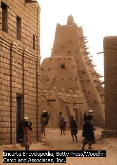
Timbuktu's most prominent landmark is the Sankore Mosque, built in the fourteenth century. The walls are made out of adobe, and every year, after the rainy season, the structure needs to be resurfaced with fresh mud; the poles sticking out are then used as scaffolding.
The stage was now set for the spectacle that marks Mali's peak, the pilgrimage of King Mansa Musa (1312-37). Unlike some of his predecessors, Mansa Musa was a devout Moslem, so one of his goals in life was to visit Mecca. He made the journey in 1324, cutting directly across the desert to Egypt with an entourage of 8,000; they reportedly brought with them a hundred pack camels that were each loaded with 300 pounds of gold.
When Mansa Musa got to Cairo, the Mameluke sultan, an-Nasir Nasir-ud-Din Muhammad, sent an emissary to greet the royal visitor at the pyramids and invite him to a summit meeting. Mansa Musa would have preferred to continue on to Arabia, so he agreed reluctantly. Normal protocol called for anyone entering the presence of the sultan to kiss the ground before him and to kiss his hand, something that would have been difficult for a king wealthier than his host to comply with. A member of Mansa Musa's entourage came up with a solution and called the king aside to whisper it to him; then the king said, "I make obeisance before God who created me," before bowing and approaching the sultan. After that they exchanged rich gifts, and the pilgrims ended up staying in Cairo for three months (from July to October) before moving on. Egyptians were impressed at the dignity and piety of their guests--one governor said they acted like they stood in God's presence all the time--but they still had a lot to learn. For example, when Mansa Musa described how in his country it was customary to give the most beautiful girls to the king, he was shocked to learn that Islam had no place for this practice, and vowed to end it immediately. By the time they left, they had spent so much money that the price of gold dropped 20 percent in Cairo, and it stayed depressed for at least twelve years.(18) Mansa Musa returned to Mali in 1325 with scholars, clerics, and a well-known architect named Ishak as-Sahili, and they established new mosques in Timbuktu, Gao and Jenné.
Mansa Musa's brother Sulayman (1341-60) managed the realm effectively, but none of the kings that followed were very competent, and the Mali empire declined as fast as it had risen. Part of the problem was the issue of succession; even in the beginning, Sundiata seemed to want the throne to pass from brother to brother, not from father to son. Within two generations after Mansa Musa's death, his vast fortune was spent. In 1375 Gao became independent, and the Songhay built an empire of their own that soon eclipsed Mali. Our list of Mali kings stops abruptly with the crowning of one Mahmud in 1390, leading some scholars to believe the kingdom broke into two or three parts at the end of the fourteenth century.(19) By 1400 the Senegambia region was also independent; most of Senegal and Gambia came under the domination of a settled tribe, the Wolof, while a pastoral tribe, the Fulani, migrated east toward the Niger River. On the banks of the upper Niger, the last part of Mali survived until the 1490s, but from the mid-fifteenth century onward, Songhay was West Africa's most important state.
![]()
The Prince of Travelers
In the 14th century Morocco produced a traveler whose accomplishments were every bit as spectacular as those of Marco Polo. He was Mohammed ibn Battuta (1304-77), who came from a family of judges in Tangiers. At first he followed tradition by studying law, but at the age of 21 he made his pilgrimage to Mecca, and once he got there he decided that seeing the world was what he really wanted to do with his life. Resolving "never to travel any road a second time," he visited the rest of the Middle East, starting with Iraq, Azerbaijan, and Iran. After returning to Mecca, he journeyed down the Red Sea to Yemen, and continued going south on the East African coast all the way to Kilwa. His third grand tour started in Mecca as well and took him to Syria and the Turkish emirates of Asia Minor, giving us a useful look at that region between the fall of the Seljuks and the rise of the Ottoman Turks.
Ibn Battuta's greatest adventures came next. From Turkey he sailed across the Black Sea to Sarai on the Lower Volga, calling upon the Mongol Khan of the Golden Horde. He escorted a Mongol princess to a diplomatic marriage in Constantinople, and gave us a rare look at that city as seen through non-Christian eyes. After returning from that mission he trekked east into Central Asia, wandered around the cities of that region for a while, and then entered India. He described the sultan of Delhi, Muhammed ibn Tughluq, as both the most generous and the cruelest man of his time, and sure enough, he first got a job in the sultan's court as a judge, but later fell into disgrace and was nearly executed. He left that dangerous place in 1342 when the sultan appointed him ambassador to China. On the way he was waylaid first by Hindu rebels, then by pirates, and ended up shipwrecked on the coast, losing all his property and the gifts for the Great Khan. Fearing the wrath of the sultan, he spent the next two years touring the Maldive Islands, Sri Lanka, Bengal, Assam and Sumatra before he decided he would resume his journey to China.
Ibn Battuta came home to his birthplace in 1349. He still had two trips left to make before he could claim to have visited every Moslem country in the world. One was easy; during the next year he crossed the Strait of Gibraltar to see Granada, the last territory of Moslem Spain. In 1352 he joined a caravan to go across the Sahara; he stayed in Mali for a year before returning with another caravan.
Unfortunately we cannot trust everything that ibn Battuta wrote. He did not visit any part of Russia north of Sarai, though he claimed he did, and his account of China is so vague that historians doubt he went there. However, everyone agrees he was at his best when he wrote about Mali, and we are blessed that he went there just a few years after the reign of Mansa Musa. His description of Mali, with its strange mixture of Moslem and animist customs, agrees with our other sources and is too detailed to be made up on hearsay. On top of that, he livens up his account with his all-too-human reactions to what he saw there: admiration for the high African standard of justice, which made crime almost nonexistent and gave Malians a feeling of security, scorn for the miserable gifts and hospitality they showed to traveling VIPs like himself(20), and outrage at public female nudity, a custom which even princesses practiced!
After his return to Morocco in 1353, ibn Battuta finally settled down. The sultan provided him with a secretary to dictate his memoirs to, and at the end of the last chapter the secretary added a note that says it all: "It is plain to see that this shaykh is the traveler of the age."
![]()
Kanem, Bornu and the Hausa States
A different kind of kingdom arose in the eastern Sahel, one which depended on agriculture and warfare more than trade, though trade remained important. It was also the longest-lived of the Sahel states, lasting for a thousand years, despite a complete relocation from one side of Lake Chad to the other.
We mentioned in Chapter 1 how Lake Chad was the only body of water that survived the drying out of the Sahara Desert. After that it served as a crossroads, being both the largest oasis and the best place to stop at on the way between the Nile valley and West Africa. In the ninth century A.D., one tribe in the area, the Zaghawa, prose to prominence over the others, and it was organized enough to found the kingdom of Kanem, north and east of Lake Chad, with its capital at the desert town of Manan.
No records survive from Kanem's first two centuries. In the eleventh century, another tribe, the Kanuri, took charge; their ruling dynasty was called the Saifawa. The first Saifawa mai (king), Umme ibn 'Abdul-Jalil (1086-98), is credited with introducing Islam to the kingdom. He may have been Kanem's first Moslem king, but we don't know what sort of inroads Islam had made before his reign, so we have to take the Islamic claim with a bit of caution.
Umme and his successors moved the capital to Nijmi, which was closer to Lake Chad. They attempted to dominate the Fezzan district of the Sahara, which meant controlling the caravan routes that passed through the Fezzan. For the trans-Saharan trade Kanem provided textiles, salt, and later on slaves, in return for copper, weapons and horses. However, the main interest of the mais seems to have been with the sedentary farmers on Lake Chad's shore. By marrying into agricultural families, and by making their crops the primary commodity sold to traders, they hoped to make the farmers rich enough to afford the upkeep of a standing army. This army was not a group of warriors on foot, armed only with spears and shields (the African norm), but men on horseback, covered with chainmail and wielding lances. Because these cavalrymen got their support from an agricultural base, much like the feudal system of Europe, it is appropriate to call them African knights. Originally the plan was to reward military commanders by putting them in charge of the people they conquered, but soon officers bequeathed their jobs to their sons, transforming the office from one based on achievement and loyalty to the mai, into one that automatically went to members of a hereditary nobility.
Kanem saw its best years under Mai Dunama II Dubalemi (1221-59). The royal chronicle of Kanem portrayed Dubalemi as a pious Moslem, who restored pure Islam in the kingdom after a lax period under his predecessors; apparently, the mais of the twelfth and early thirteenth centuries had tolerated non-Moslem customs, which included giving political power to the queen mother and other women of the court. In addition, Dubalemi launched a series of jihads in all directions: north into the Fezzan, west as far as Hausaland, east to Darfur, and south as far as the Adamawa grasslands in Cameroon. Still, it is best to draw dotted lines on a map of Africa to show how influential Kanem really was; the farther one got from Nijmi, the more likely it was that the locals would give only minimal allegiance to the mai, and nomads were likely to escape paying tribute altogether. To the south, expansion had to stop where the grasslands of the Sahel gave way to the equatorial jungles, because forests of any kind cancel out much of the advantage of having cavalry.
The people living south of Lake Chad were still unconverted, so they provided the largest source of slaves to sell to the Arabs; we'll be hearing a lot more about this disturbing practice in future chapters. Dubalemi also took credit for destroying the mune, a mysterious object held in reverence by pagans and believed to possess supernatural powers. Finally, Dubalemi founded a madrasa and hostel in Cairo for Kanuri citizens living in Egypt and/or traveling to Mecca, as well as an embassy in Tunis.
Dubalemi left an overextended kingdom, which came undone during the century and a half after his death. There were several reasons for this: rivalry among Dubalemi's sons, many of which had been appointed to high positions; rebellion from Kanem's non-Moslem subjects, avenging the destruction of their sacred symbol (the mune); and relative poverty whenever peace broke out or a battle was lost, because the military brought in much of the kingdom's wealth. The biggest threat, however, came from the Bulala, a clan that had split off from the Kanuri tribe and now contested with the Saifawas for leadership. At the end of the fourteenth century, internal struggles and external attacks tore Kanem apart. Between 1387 and 1400, six mais reigned, of which the Bulala killed five.
One of the kings at this time, Umar I (1393-98), became a refugee; he abandoned Kanem to the Bulala, and moved to the lands southwest of Lake Chad (northeastern Nigeria), taking the Kanuri people with him. There he established a new kingdom named Bornu, but trouble followed him there. The Bulala continued to make raids from Kanem, and the So, a Chadic tribe already living in the area, resisted the newcomers, to avoid losing their ethnic identity to assimilation (the So had been the target of Kanuri raiders in the past, when they went looking for slaves). There also was more infighting within the Saifawa dynasty, to the point that one prince went into exile, living at Kano in the 1420s. The fifteenth century would be more than half over before this "time of troubles" ended for the Saifawas in Bornu.
Kanem-Bornu usually got along well with its neighbor to the west, the Hausa of northwestern Nigeria. Traditionally the Hausa were divided between seven city-states: Kano, Rano, Katsina, Zazzau (Zaria), Gobir, Kebbi, and Auyo. Like the Swahili on Africa's east coast, the Hausa were never united, but because of their success as traders, they were influential over a wide area, in this case the lands between the Niger River and Lake Chad.
Though we classify the Hausa as a Chadic tribe, their actual origin is unknown. Some scholars believe their ancestors migrated from the Sahara; others believe they came from Lake Chad; still others believe they were indigenous, always living where we see them now. Hausa legend asserts that their founder was an exiled Arab prince named Bayajidda. He married the queen of Daura and had a son named Bawo, who in turn had seven sons; each grandson is identified as the first ruler of a Hausa kingdom. Of these kingdoms, Kano was usually the most important, and probably the oldest; our chief source of Hausa history, a nineteenth-century work in Arabic called the Kano Chronicle, begins listing kings of Kano in 998 A.D. However, even if the Bayajidda story is true, it doesn't rule out the possibility that Kano existed as a village previously. Indeed, the Kano Chronicle describes a struggle that went on for much of the eleventh and twelfth centuries between the kings, who wanted to build walled cities, and the native priests who had been the traditional rulers of the area. These priests got their power from sacred groves and shrines in rural locations, so they saw urbanization as a threat; the kings had to capture or destroy all the holy places before they could rule without opposition.
However they got started, the seven city-states became strong trading centers between 1000 and 1350. Typically each one was surrounded by a wall and had a mixed economy of intensive farming, cattle raising, craft making, and later slave trading. The monarchs enjoyed less power than the kings of the Sahel super-states; many were probably elected, and most of the time they acted as a referee over a network of feudal lords.
Islam must have been familiar to the Hausa from an early date, due to Moslem merchants and other visitors, but it took longer to convert the kings here than it did in Mali or Kanem-Bornu. The first king identified as a practicing Moslem was Yaji I of Kano (1349-85), and because he captured Santolo, the last of the traditional religious centers, the chronicler of Yaji's reign described the conflict between city and countryside as a jihad against paganism. However, Yaji and his successors remained willing, perhaps too willing, to accommodate traditional beliefs and their followers. They probably did this because political relationships were complex in Hausaland, and the king, unlike a Bornu mai, was powerless without the cooperation of his warriors and subjects, many of whom remained non-Moslem until the Fulani conquest of 1807.
![]()
Mapungubwe, Thulamela and Zimbabwe: A Heritage Restored
We noted earlier that civilization was relatively late in coming to southern Africa. One reason was already mentioned: all the centers of civilization were located far to the north, and they had considerable natural barriers to overcome on the way south. The other factor was that this region was underpopulated, at least until the Bantu migration; elsewhere I have commented that you must concentrate a large group of people in one place to produce the specialists a civilization needs. What finally got civilization started here was mineral wealth; southern Africa is the world's richest source of gold, diamonds, chromium, and other valuable minerals. Anyone can pick up gold nuggets lying on the surface, but organization is required for any cooperative effort, like the digging of a mine. Around 1000 A.D., the locals got organized enough to do just that, digging for gold and selling it to traders from the Swahili cities.
The oldest evidence of mining activity comes from a site called Mapungubwe, the "Hill of the Jackals," on the south bank of the Limpopo River, where South Africa, Botswana and Zimbabwe meet. In 1926, E. S. J. van Graan, a white South African farmer and prospector, began hearing rumors of buried treasure on a sacred mountain, and for six years he pursued every lead he could find that might point to the location of this peak. Finally in 1932 he found it, accompanied by his son, three friends, and a local who was very reluctant to show them how to climb the outcropping of boulders that marks Mapungubwe. On the top, the visitors saw potsherds, glass beads, and bits of copper and iron. Even more interesting was the gleam of a gold object at the base of a slope. Over the course of two days they found and looted some graves, taking away valued objects like a golden rhinoceros. However, van Graan's son had been an archaeology student at the University of Pretoria, and he reported the find to his teacher, Professor Leo Fouche, when his conscience got the better of him, allowing a proper excavation to take place afterwards.
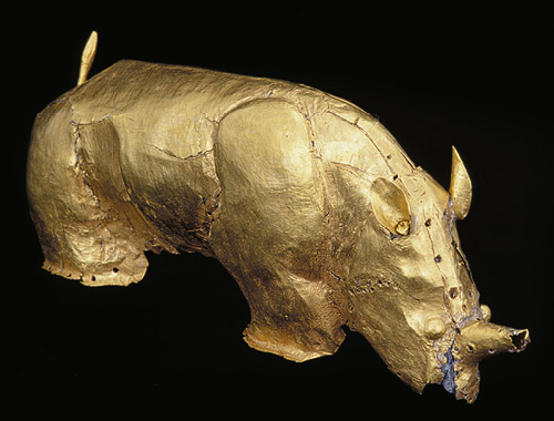
The golden rhinoceros of Mapungubwe. Five inches long, it was made of gold foil, encasing a wooden core that disintegrated long ago. Note that it has just one horn; one horn is characteristic of Indian rhinos, but not African ones, suggesting that the rulers of Mapungubwe traded with Asia. From Metmuseum.org.
Since the 1930s a total of twenty-three graves have been excavated. The bodies in three of them were buried sitting up, with a collection of jewelry made of gold, copper and glass, identifying them as royalty. This is the oldest example in southern Africa of a society with a sharp differentiation between the upper and lower classes, not a common feature in communities that live by hunting or subsistence agriculture.
Mapungubwe presented the South African government with a challenge. For most of the twentieth century, South Africa had a harsh white-supremacy policy (apartheid), and one of the justifications for it was the argument that no civilization had existed there before the Dutch built the first European settlement, at Cape Town in 1652. In fact, it was widely believed that blacks didn't even live in the region before 1800, and aside from the Europeans, the only inhabitants were a few Bushmen, who were too primitive to matter. When evidence was found that pointed to advanced communities in the region before the European arrival, it was automatically assumed that these communities were built by non-African intruders, most likely from the Middle East. Therefore, little was said about Mapungubwe for fifty years. Not until the dismantling of apartheid began in the 1980s was this discovery given much attention, and the first accomplishment of southern Africa's black tribes was finally put in the proper perspective.
Two hills were inhabited at the site, and radiocarbon dates show that the oldest settlement was on one of the hills, Bambadyanalo. Around 1045 the residents moved from Bambandyanalo to the sister hill, Mapungubwe, perhaps because the town had become overcrowded. After this the high places were reserved for the nobility, with everybody else living on the surrounding plateau. The people made a living through farming, herding cattle and elephant hunting (for ivory), but from 1200 on, most of their wealth came from gold.
At its peak, Mapungubwe probably had a population of 5,000. Then suddenly around 1300, it was abandoned. We aren't sure why; the climate seems to have gotten cooler and drier, or maybe they left because the local gold supply ran out. Now to the north, Great Zimbabwe began to grow in importance. It's a safe guess that Mapungubwe and Great Zimbabwe were populated by the same tribe, the Shona, because both used a distinctive architecture for building stone walls.
A similar site was located at Thulamela, 200 miles to the east in Kruger National Park. Discovered in 1993, it has also been excavated by the University of Pretoria, but archaeologists of the post-apartheid era have treated Thulamela far differently from Mapungubwe; since 1996 the excavation has been open to the public, with the scientists going so far as to re-bury skeletal remains when a local tribe, the Venda, requested it.
Thulamela means "Place of Giving Birth" in the Venda language. A stone-walled citadel stood here between 1250 and 1700, and like Mapungubwe, the high place doubled as a burial mound for its rulers. Also interesting is the fact that nearly 200 pre-colonial mines have been found in the area, many of them iron mines. The tribes living here--the Venda, Tsonga, Shangaan and Sotho--already knew how to convert iron to carbon steel, and obviously they did not need the help of European geologists to locate mineral riches.
Framed by the Limpopo and Zambezi Rivers, the Zimbabwe plateau is one of the most desirable places to live in southern Africa. To the east it slopes down toward the coastal plain along the Indian Ocean, while to the west the forests and savanna gradually turn into the Kalahari Desert. We already mentioned the metals; sources of gold, iron, tin and copper are all within easy reach. The plateau has abundant rainfall, fertile soil, and plenty of grazing land and timber, all attractive qualities to a cattle-herding tribe like the Shona. Most important of all, the climate is relatively mild, to the point that the tsetse fly, which has killed millions of people and cattle with the dreaded sleeping sickness, seldom bothers anyone here.
Anyway, the Shona arrived on the Zimbabwe plateau as part of the great Bantu migration, in the first millennium A.D. Once they arrived, they lived simply, with a typical tribesman measuring his wealth not in land or money, but by the number of long-horned cattle he owned. Then the Swahili contacted them, and trade developed to meet the Swahili demand for ivory, and later for gold. The Shona didn't have much use for these luxuries, so they bartered them for cloth, beads, and foreign manufactured goods. However, most of the profits from this commerce was concentrated in the hands of a few people, who now became the ruling elite; the peasants earned little for their hard labor. As they grew richer, the upper class came to see themselves as a separate community from everyone else, so they moved to the tops of hills, and ordered stone walls to enclose their neighborhoods, using masonry to make a political statement.(21)
People lived on the site of Great Zimbabwe as early as 320 A.D., give or take 150 years, but until about 1200, it was just another village. The gold itself was not mined in the immediate neighborhood, but Great Zimbabwe served as a suitable location for a gold trading center. Then in the thirteenth century construction began on the main city. Here the Shona were blessed with an abundant supply of granite, and the sharp change in temperature between day and night caused the granite to crack into small blocks, which then could be easily shaped into building stones. At first the walls used stones that were irregular in size and laid in uneven courses, without a foundation, but as time went on the quality of the masonry improved. Population also increased; at its peak, in the fourteenth century, Great Zimbabwe may have had as many as 18,000 inhabitants.
The stonework of Great Zimbabwe is remarkably precise; in most places the granite blocks were fitted together so well that no mortar was needed. The outer wall was 820 feet long, and in some places stood as much as 17 feet high and 32 feet wide; mounted at various points on it were soapstone poles, carved to resemble hawks. Some of the top rows of stones in the walls were laid diagonally, to create a repeating chevron pattern; obviously the wall was raised more for personal privacy than for defense. Inside this was a smaller wall, enclosing an area that served both as a royal residence and a temple. Some large huts were made of daga, a cementlike mud that included clay from termite mounds, and platforms and smaller enclosures were used to display pots, spears and more soapstone birds; evidently these were sacred objects. Each bird bears distinctive markings, leading archaeologists to believe that they were memorials to dead kings (an African "totem pole," of sorts). Most puzzling is a 30-foot-tall conical stone tower; it used to be thought of as a shrine or tomb, but it is a solid structure, with no known tunnels or chambers inside; perhaps this is a monument to the king's power.
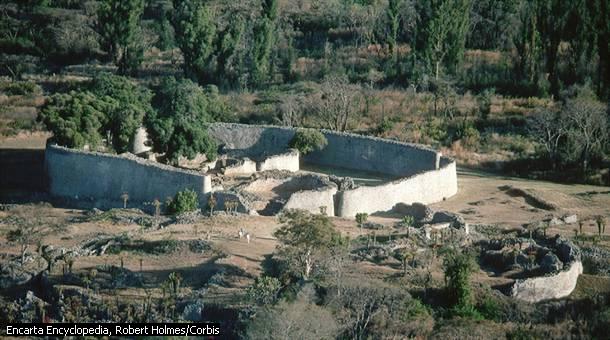
The ruins of Great Zimbabwe.
After 1400, Great Zimbabwe suddenly declined. We don't know why, because the residents could not write, but we can make guesses, and we see the evidence in the youngest walls, which were laid haphazardly, with stones wedged together. Many scholars put the blame on overpopulation, suggesting that farmers ruined the soil's fertility or that woodcutters stripped the forests in the vicinity; either way, this would have forced everyone to leave. Or maybe, as with Mapungubwe, the nearest gold deposits were worked out. At any rate, gold production was past its peak by 1440, when a Shona king named Mutota came to power and moved north, to a new capital at Khami. By 1500 Great Zimbabwe was almost completely deserted, except for a few residents who stayed until about 1830, when they too abandoned the place.
Zimbabwe wasn't a proper name originally. There are hundreds of ruins on the plateau, which the Shona call dzimba dza mabwe, meaning "venerated houses," and this became Zimbabwe when transliterated into English. Gradually this name came to be applied to the largest of these ruins, hence Great Zimbabwe. Not until 1980 did Zimbabwe become the name of a country. When that happened, images of the soapstone birds found at Great Zimbabwe were placed on the new nation's flag and currency, giving Zimbabweans a source of cultural pride.
When the Portuguese settled on the Mozambican coast in the early sixteenth century, they heard about a particularly large set of ruins inland, and called it Symbaoe, but they never saw it first-hand; travel in the African interior was too risky for whites. Unfortunately for us, nobody--not a European, Arab, or even a Swahili visitor--ever provided a written account of what Great Zimbabwe was like when inhabited. The first outsider to see the ruins was Karl Mauch, a German geologist and explorer, in 1871. Mauch was one of those who believed that the legendary land of Ophir was somewhere in Africa (see Chapter 4), and he quickly convinced himself that he had found the home city of the Queen of Sheba. Could King Solomon's mines be far away?
Mauch found a receptive audience for his theories among South Africa's white colonists, who couldn't imagine that the Shona guides who acted so reverently around the ruins of Great Zimbabwe might be the descendants of the builders. When Cecil Rhodes, the British entrepreneur who conquered southern Africa's interior (and subsequently gave it the name of Rhodesia), arrived on the scene, he sent an antiquities expert, James Theodore Bent, to examine the site. The first artifacts he dug up (potsherds, copper spearheads, and some gold-working crucibles) were obviously locally made, prompting him to guess, "I have not much faith in the antiquity of the ruins; I think they are native." But then he found four of the bird monoliths, and decided that they resembled Phoenician stela; therefore, somebody from the Middle East must have built the place. The treasure hunters who followed him, including an overzealous archaeologist named Richard Hall, all agreed: Great Zimbabwe could not have been built by blacks.
This suited the European colonists of South Africa and Rhodesia just fine, and now they imagined that a lost white civilization had preceded them there in ancient times.(22) Then in the early twentieth century, two more archaeologists gave the site a comprehensive study: David Randall-MacIver (1905) and Gertrude Caton-Thompson (1929). Randall-MacIver found that all the pottery and stonework bore a relation to what the Shona had made more recently, and the only foreign objects discovered, like Chinese porcelain and Arab glass, could easily be explained as products the locals had imported. To him Great Zimbabwe was "unquestionably African in every detail." Caton-Thompson came to the same conclusion, declaring that, "The ruins are, in my opinion, indigenous in a full sense of the term. The romance of an ancient white civilization was finally put to rest; in 1931 Caton-Thompson wrote that the only mystery about Great Zimbabwe "is the mystery which lies in the still pulsating heart of native Africa."
This is the End of Chapter 5.
FOOTNOTES
1. The fate of the Pharos, the great Alexandria lighthouse, is also not clear. We know it served Egypt for more than a thousand years, even after it was damaged by an earthquake in 365 A.D. There is a commonly told story which claims that in 850, the Byzantine emperor hatched a plot to hurt Arab commerce by destroying the Pharos. He sent a Christian spy, who told the caliph of Cairo that a great treasure was buried under the lighthouse. Sure enough, the greedy caliph ordered the structure torn down. The top two stories of the tower were destroyed, along with the lighthouse's great bronze mirror, before the caliph realized he had been duped. However, he could not restore what he had taken away, so he had to leave the Pharos as a stone stump. Though the story is attractive, I doubt if any of it is true. First, the dates don't allow it. Cairo didn't exist in 850, and Egypt didn't yet have a caliph of its own; both of those things were introduced by the Fatimids in the next century. Second, we hear from visitors that the Pharos was still working as late as 1115. What really brought down the lighthouse (literally), were the earthquakes that strike the eastern Mediterranean so often. Two bad earthquakes ruined the structure in 1303 and 1323, to the point that Mohammed ibn Battuta, the famous traveler who appears later in this chapter, reported that it wasn't safe for him to go inside. Finally in 1477, Qaitbay, the Mameluke sultan at the time, used the remaining stones from the lighthouse to build a fort.
2. The Visigoth kingdom was persecuting the Jews living in Spain, and many of them fled to North Africa, augmenting the Jewish community there. In addition, Judaism probably made some Berber converts, for the same reason that Donatism had persisted to this date: both were alternatives to the state-sponsored Orthodox Christianity of Constantinople.
3. "Encompassed by the enemies of their religion, the Ethiopians slept for near a thousand years, forgetful of the world by whom they were forgotten."--Edward Gibbon
4. East Africans have legends about a tribe named the Waqwaq, which used to live on the Kenyan or Tanzanian coast. Their description of the Waqwaq sounds very much like the Malagasy, suggesting that the Asian explorers first landed on the mainland, and stayed there for a while before sailing south to Madagascar. If this is true, all they left behind on the mainland were their crops.
The Malagasy themselves claim that more than 2,000 years ago, a people called the Vazimba lived on their island. They describe them as "white pygmies," and act with extraordinary care when near a very old tomb, out of fear of what the spirits of the Vazimba might do. Unfortunately it's not clear if the Vazimba are an indigenous race that lived there before the outriggers arrived, or one that the settlers remembered from the islands of Southeast Asia (the Negritos and Homo Floresiensis come to mind).
5. Many texts use the geographical term "Sudan" to describe the part of West Africa bordering the Sahara. This is easily confused with the modern-day country named Sudan, so in this narrative we'll continue to call this region the Sahel.
6. North African camels are always dromedaries, the one-humped species native to Arabia. Two-humped Bactrian camels live strictly in the relatively cooler deserts of Asia's interior. The Zagros mts. in Iran marks the dividing line between the two camel species.
7. Kola nuts were not in demand as a foodstuff, but as a source of caffeine; the world hadn't discovered coffee yet. For the coffee story, see the section in Chapter 4 about Ethiopia, and Chapter 13, footnote #5 of my Near Eastern history.
8. One of the mining spots in the middle of the Sahara was Taghaza, a village built entirely with blocks of salt, and roofed with camel skins. Although this sounds fascinating, Mohammed ibn Battuta hated the place, when he passed through on his way to Mali in 1352. He wrote: "This is a village with nothing good about it. It is the most fly-ridden of places."
9. Ghana's original name was preserved in the modern name of Ouagadougou, Burkina Faso's capital.
10. Most of the West African kingdoms that came along after Ghana also gave their monarchs a foreign origin, usually declaring that an Arab or Berber founded the dynasty. Though possible, such stories should be taken with a healthy dose of skepticism, since the Arabs and Berbers are white, while these kings and their people were always black by the time historical records about them appear. Likewise, the city-states on the East African coast, like Kilwa, claimed that their first kings were Arabs. They probably made such claims to give the royal family an impressive Islamic lineage, just as the Christian kings of Abyssinia claimed descent from Solomon and the Queen of Sheba (see Chapter 4).
However, in at least one case such legends may be correct. In 1999 members of the Lemba, a small South African tribe that claims Jewish ancestry, submitted to DNA testing, and their men have the so-called "Cohanim gene," a structure on the Y chromosome that so far has only been found with Levites. White Jews spent a decade debating whether the Lemba are really Jewish, before allowing them to come to Israel. In the picture below are some Lemba families, enjoying their first Passover in the Holy Land.
11. From the Book of Roads and Kingdoms, written around 1067 by al-Bakri of Cordova, a Spanish geographer.
12. Ibn Khaldun, The Muqaddimah, An Introduction to History, Bollingen Series, Princeton University Press, Princeton, NJ, 1967 (1981 edition used), pg. 120.
13. Ubaidallah never really trusted the Berbers; he had to execute al-Shii after taking charge, because he felt the Berbers were more loyal to him. The soldiers he did trust were slaves purchased by the Aghlabids--Black Africans from the Lake Chad region, and Slavs from Europe. Even Jahwar, the general who conquered Egypt, was a slave, a Greek-speaking Sicilian. Thus, like their Abbasid opponents, the Fatimids came to depend on an army of slaves. To us, it must seem extremely risky to let slaves have weapons, and the Mahdi had to give them whatever they wanted for the system to work, so it may not have been clear who was controlling whom!
14. The Swahili culture was confined to the coast because the climate there was more pleasant, and the nearest inland tribes were warrior herdsmen like the Masai, who saw no need or desire to give up their lifestyle.
15. We don't know where the ribat was located; our best guess is that it was on the same site as Nouakchott, the modern capital of Mauritania.
16. The first recorded use of a cannon anywhere outside of Asia was at Sijilmasa, in 1275. Presumably it came from somewhere else, but we don't know where. The author who supplied me with this factoid thought the Mamelukes captured the cannon in their 1260 battle with the Mongols, but he couldn't explain how it got to Morocco after that. Personally I doubt it happened that way, as the Mamelukes weren't interested in firearms until everybody else had them; we're talking about the age of chivalry, remember! If the cannon came from Europe, we'll probably never know for sure; the Europeans didn't bother to record when they learned the secret of gunpowder, and whether they got it from China or invented it locally.
17. Two new gold fields started producing in the fourteenth century, both in the forest zone directly south of Mali. One was along the Black Volta River, in Burkina Faso. The other, in the Akan forest of modern Ghana, would be an important factor in Europe's exploration and colonization of West Africa.
18. In 2012 the website CelebrityNetWorth.com published a list of the 25 richest people who ever lived. Number 1 on the list was Mansa Musa, with a calculated net worth, adjusted for inflation, of $400 billion in 2012 dollars. By comparison, the richest man of our time, Bill Gates, was worth only a third as much, at the peak of Microsoft's fortunes in 1999. You may find it hard to believe that one person can bring down the price of gold through his spending habits, but when you control a near-monopoly over the world's production of gold and salt, it can be done!
Some of Mali's gold eventually found its way to Europe, because Egypt was a regular customer of the Venetian merchants. Thus, Black Africa had an influence on the European economy, and may have even helped finance the Italian Renaissance, while it was still beyond the limits of the "known world." The famous Catalan Map of 1375 shows the coastline of Spain and North Africa, and south of a barrier that represents the Atlas mts., the cartographer drew a picture of Mansa Musa, sitting on his throne and holding a gold nugget the size of a baseball, while an Arab merchant approaches him.
While in Cairo, Mansa Musa told a story about a predecessor, Abubakari II. He claimed he was traveling across the desert to reach Mecca because Abubakari failed to find a water route to the holy city. According to him, Abubakari launched 200 ships into the Atlantic; only one returned, its captain claiming that the others had been taken away by a "river with a violent current in the middle of the ocean." Abubakari built a second fleet, and decided to lead it himself. He and the fleet were never seen again, though Afrocentric historians like Ivan Van Sertima believe that the Malians made it to Brazil and settled down there, reaching America nearly two hundred years before Columbus. I'm skeptical myself, due to a date conflict; everything I've read about the supposed expeditions has them taking place in a timeframe of 1310-1312, but the royal chronology that we have for Mali places Abubakari a full generation earlier (1274-85).
19. This is a good place to put in a few words about the Dogon tribe. They were Mandinka originally, but in the fourteenth or fifteenth century they rejected Islam, broke off from the main tribe ruling Mali, moved into the mountains south of the Niger River's big bend, and built their cliffside communities. Today the Dogon have one of the most interesting tribal cultures in Africa.
20. "Ten days after our arrival we ate a porridge, which they consider preferable to any other food. The next morning we were all sick."--Ibn Battuta on the cuisine of Mali.
21. David N. Beach, a leading historian of Zimbabwe, noted that the poor lived in overcrowded, disease-prone conditions, right outside the main city walls, in what could be called a medieval slum: "Zimbabwe has often been viewed through an aura of romance, but perhaps a cloud of smoke and flies would be more appropriate from a standpoint of archaeological accuracy. The contrast between the rulers and ruled must have been quite striking."
However, life for the chiefs wasn't unearned luxury. Because they were regarded as demigods, they had to live apart from most of their subjects, to reinforce a sense of aloofness. They also had to keep themselves in perfect health, and were expected to commit suicide if they became terminally ill, or were slowed down by old age. Remember that a similar custom was practiced with the first pharaohs of Egypt.
22. A 1938 Rhodesian travel poster had the caption, "The Riddle of Rhodesia," and showed a native paying homage to the ruins of Great Zimbabwe, with the ghost of the Queen of Sheba watching. The schools of Rhodesia continued to teach that the ruins had a non-African origin until the white-ruled regime fell in 1980.
Support this site!
![]()
PAGE NAVIGATOR
A History of Africa
|
Other History Papers |
Beyond History
|