 | The Xenophile Historian |

 |
 |
 |
 |
 |
 |
 |
 |
 |
 |
 |
 |
 |
 |
 |
 |
 |
 |
 |
 |
 |
 |
 |
 |
 |
 |
 |
 |
 |
 |
 |
 |
 |
 |
A History of Latin America and the Caribbean
Chapter 1: Ancient America, Part II
Before 1492
This chapter is divided into three parts, which cover the following topics:
Part I
| Introduction | |
| The First Americans | |
| Before the First Horizon | |
| The Mysterious Olmecs | |
| The Chavin Culture: Peru's Great Leap Forward | |
| The Paracas: Dream Weavers | |
| The Zapotecs | |
| Rise of the Maya | |
| Teotihuacan, the City That History Forgot |
Part II
Part III
| The Toltec Middlemen | |
| Yucatan: The Maya Epilogue | |
| The Mixtecs | |
| Forerunners of the Incas | |
| The Tepanecs and the Rise of the Aztecs | |
| The Bloody Splendor of the Aztecs | |
| The Inca Conquests | |
| Tahuantinsuyu | |
| On the Threshold |
The Moche: Masters of Clay
After the Chavin and Paracas cultures disappeared, three new cultures took their place, dominating Peru from 1 to 700 A.D. These were the Moche (also spelled Mochica) in Peru's northern coastal valleys, the Lima culture on the central coastal plain, and the Nazca in the southern coastal desert. If you go back to the table near the beginning of this chapter, you will see they lasted from the end of the Early Horizon Period, all the way through the Early Intermediate Period, and into the first century of the Middle Horizon Period. This time frame saw the rise of a society where purely residential communities outnumbered those built around ceremonial centers, and where a powerful upper class, rather than just priests, were in charge. Communities in high places were fortified, showing us that people were now concerned about the need for defense, but the typical community at this stage was a small, unfortified village in the valleys or on the coast. The Moche had an improved political organization as well, judging from the size of the area that was theirs, but it is not clear whether they were a unified state, or an alliance of city-states with a common culture and ideology. By contrast, the Nazca organization remained at the city-state level. The Lima culture did not even accomplish as much as the Nazca; all they did was build some temples (at Pachacamac and within the city limits of modern Lima), and leave ceramic works.
We divide the Moche culture into three stages: the early Moche (1-300), when the culture was developing; the middle Moche (300-550), the time of its greatest strength; and the late Moche (550-700), when the cities were most highly developed but the civilization was in a downward spiral. The Moche controlled nine valleys (the Lambayeque, Jequetepeque, Chicama, Moche, Virú, Chao, Santa, and Nepena) in an area 340 miles long and 50 miles wide, with boats along the coast maintaining communication between the valleys. Because they left no written records, like the cultures before and after them, we named the Moche after the Moche valley and a modern village named Moche. The Moche valley also contains the most important religious monuments, the Huaca del Sol (Pyramid of the Sun, huaca is a Quecha word meaning holy place) and the Huaca de la Luna (Pyramid of the Moon). Built from an estimated 130 million adobe bricks, the Huaca del Sol is the largest pre-Columbian adobe structure in the western hemisphere. Unfortunately only about a third of the original huaca stands today; it has been severely damaged by erosion, and by sixteenth-century Spanish treasure hunters digging holes in it.(31) The Huaca de la Luna, on the other hand, was left mostly undisturbed, presumably because it is a smaller structure, until archaeologists found several intact burials there in the late twentieth century.
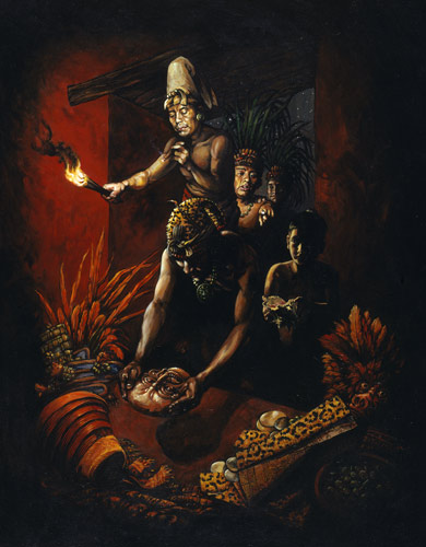
Among all the pre-Inca cultures that South America produced, the Moche were the most creative. They were talented in metallurgy, ceramics, jewelry, irrigation, adobe architecture, and textiles. The work they did in ceramics is astonishing; besides vividly painted pots, they produced some of the most realistic portraits ever done with clay. In addition, Moche artisans did not simply produce idealized beauty; if the subject had some disfigurement like leprosy, skin lesions or blindness, it appears in their clay likenesses, too. Another popular subject was animals, rendered with the same realism as people.(32)
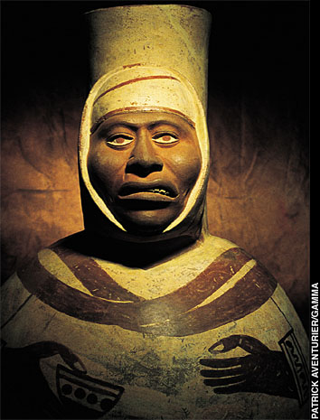
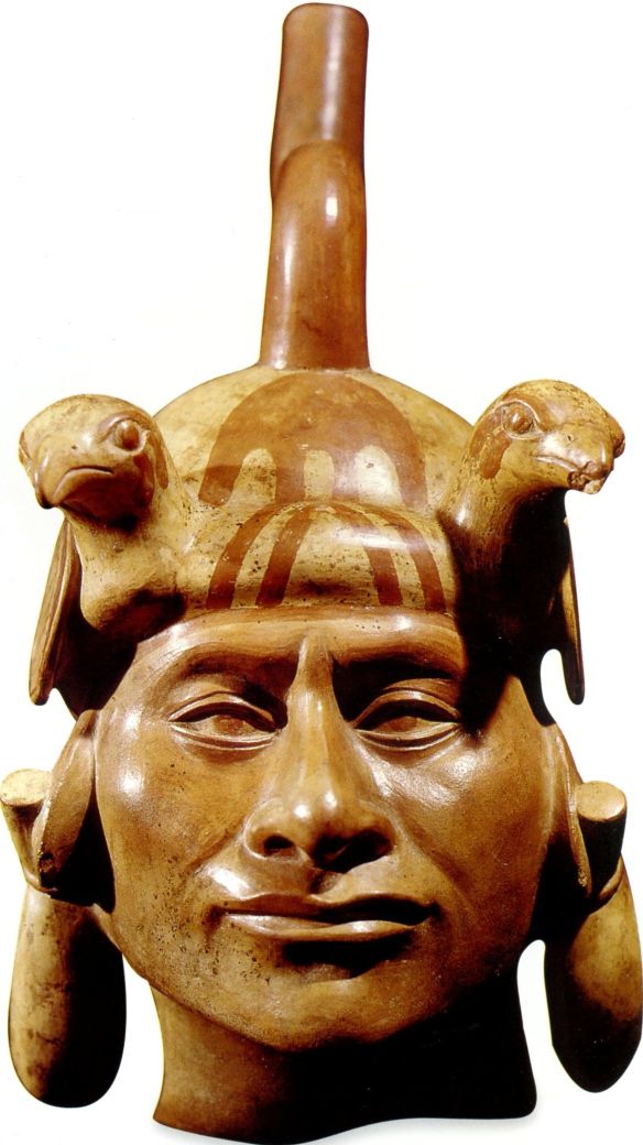
Here are two examples of ceramic Moche portraits, of a potter (top) and a lord (bottom). It is easy to imagine that real people posed for these works, so the reader may be interested to know that some pots were cast from molds, meaning that they could be mass produced. However they were made, these pots are too pretty for everyday use; they were probably only used in special rituals.
Aside from the portrait and animal pieces, the Moche were very particular about what went on their pots. Mundane scenes of everyday life, such as farming and the making of bricks, were not shown. Instead, most scenes showed what they considered important, like religious ceremonies and the supernatural realm. The most common scene is a sacrifice that was considered very important. In this ceremony, four priests cut the throats of bound prisoners, caught the blood in goblets, and drank it; it is unclear whether the victims were the losers of gladitorial contests, or captured enemy soldiers from a non-Moche tribe. Christopher B. Donnan, a UCLA professor who has organized a database of photographs of Moche artifacts, identified the priests taking part in the ceremony as follows:
A. The head priest is decked out as a fearsome warrior, with a helmet and protective clothing, and thus is named the Warrior Priest. Sometimes a dog appears at his feet; a dog of the same breed was found in one of the tombs described below.
B. The second priest, who hands a blood-filled goblet to the Warrior Priest, is called the Bird Priest because he wears a headdress with an owl on it.
C. A priestess holds another goblet; she wears a headdress with long plumes and has long braids to match. Often she stands next to more goblets.
D. An attendant, usually shown standing behind the priestess.
The scene described above is not the only gruesome subject in Moche art. Other pots, as well as murals on the Huaca de la Luna, show frightening deities like an octopus with sharp teeth (called the Decapitator or Ai Apaec by archaeologists), battling warriors, the taking of heads as trophies, priests hanging the defleshed bones of sacrificed victims on ropes, hideous punishments inflicted on criminals, and individuals practicing various sex acts. Some of the latter are so risqu� that you would do a double-take, if you saw a Moche pot in today's novelty shops; since kids may be reading this, I'd better not show any pictures of them. Many scholars did not want to believe these scenes of sex and violence really happened, so they proposed this kind of art was an exaggeration, scary stuff promoted by the priests to show the kind of power they had over everyone else.
However, discoveries in recent years have yielded evidence that the scenes were real. In 1987 and 1991, Donnan and two Peruvian archaeologists, Luis Jaime Castillo and Walter Alva, excavated four tombs in the Jequetepeque valley, one at San José de Moro and three at Sipán. All the tombs had escaped treasure hunters, and each contained the decomposed remains of a skeleton, coffin and costume, surrounded by more pots, tools the deceased would have used, and offerings like llamas and human companions. When reconstructed, the costumes worn by the deceased--fine cotton dresses bedecked with ornaments of beads, gold and silver--matched those of the priests in the sacrificial ceremony, so Donnan identified the occupant of the first tomb as a priestess (see C above), and those of the Sipán tombs as two Warrior Priests and a Bird Priest. One Warrior Priest was even buried with the dog portrayed in the ceremonial scenes.(33)
More disturbing evidence turned up in the late 1990s when three other archaeologists, Santiago Uceda of the University of Trujillo, Steve Bourget of the University of Texas at Austin, and John Verano of Tulane University, excavated around the huacas of Moche. In the mud of two plazas they found the skeletons of dozens of people who had been buried there, after more than one sacrifice, accompanied by almost as many ceramic statuettes of captives. The skeletons belonged to young men who had multiple healed fractures on their ribs, shoulder blades, and arms, suggesting they had been in fights (ritual combat?). Perhaps these were champion gladiators, who had survived several fights and were sacrificed when they lost a contest. Also found on the bones were cut marks where you would expect to find them if the victims' throats were slit, and if the flesh was stripped off the bones later. The new conclusion archaeologists have to make is that the scenes from Moche art were accurate representations of typical behavior, if not records of specific events.
Earlier in this chapter, it was suggested that changes in climate disrupted the Olmec civilization, and helped the Chavin culture get started. We now know that world climates suffered a really bad hiccup that lasted for a sixty-year period in the sixth century A.D. In Peru, this caused several years of heavy rains and flooding from 535 to 563, followed by a drought that lasted until 594. Scientists who study ancient climate data like tree rings do not yet agree on what caused all this; it could be a volcano filling the sky with dust (see footnote #26), a mega El Nino-La Nina cycle (see footnote #10), or maybe both. Old World civilizations like Byzantium reported cold weather and epidemics at this time, while in the New World the Maya and the Moche suffered even more, no surprise if El Nino was part of the disruption. In the case of the Moche, this is where we have the break between the middle Moche and late Moche cultures. Floods around the Huaca del Sol and the Huaca de la Luna covered some houses with as much as thirty feet of sediment; then the prolonged drought caused the local inhabitants to move from Moche to Pampa Grande, on the Lambayeque river nearer the mountains. But even here they could not control the water source; by 700, more floods caused this city to be abandoned as well.
During its last 150 years, the Moche civilization pulled back to two river valleys, the Moche and the Jequetepeque. The Jequetepeque settlements were fortified, a sign that either the Moche were struggling to keep control over scarce resources, or had been attacked by an enemy. After 700 the Huari, a tribe from the Andes highlands to the south, occupied the Moche valleys (Huari-style pottery has been found in the Huaca del Sol), but we don't know if they finished off the Moche, intermarried with them, or simply moved in after the Moche were gone. Whatever happened, it also looks like the Muchik and Sican cultures, which existed respectively on the northern and central Peruvian coasts after 700, were directly descended from the Moche. If this is true, the Moche did not die out; they are among the ancestors of today's Peruvians.(34) What we do know is that climate change was not the only thing that brought down the Moche civilization; there was an unidentified human factor as well.
![]()
The Nazca: Lines In the Desert
Six hundred miles south of the Moche domain, the Nazca inherited the traditions of the Paracas culture. They were based in the Nazca and Ica valleys, located southeast of the Paracas peninsula and thirty-eight miles from the Pacific. The largest Nazca site was Cahuachi, a ceremonial center with more mounds and plazas like the ones we have discussed in other parts of Peru, and made holy because several springs emerged from the ground at that spot.(35) Like the Paracas, the Nazca lived by farming and fishing, made fine pottery and excellent textiles, mummified the dead, and performed trepanation and cranial manipulation. They continued to worship the Oculate Being, a Paracas deity. Two animals not found in the desert, the orca (killer whale) and the monkey, may also have been deities; they were common art subjects, anyway. As with the Moche, the Nazca culture has been divided into three stages: the early (formative) Nazca from 1 to 450 A.D., the middle Nazca from 450 to 550, and the late Nazca from 550 to 750.
The Nazca really had a thing for collecting human heads. This is no surprise, inasmuch as other South American Indians practiced headhunting (e.g., as recently as the 1960s, tribes in the Amazon basin would shrink the heads of their victims, for easy transport). Still, the best examples of “trophy heads” come from the Nazca, thanks again to the extremely dry climate, and they collected quite a few of them, especially during the middle Nazca period; Nazca art also shows trophy heads with gods or the warriors who took them. Most of the heads have a hole in the forehead so that they can be carried on a string; some also had their lips pinned shut, to keep the spirit if the dead from speaking. For a long time it was simply thought that these were the loot of war, collected for the same reasons that prompted World War II veterans from the Allied nations to come home with Nazi flags, German pistols or Japanese swords. However, in 2009 a study was published announcing that a chemical analysis had been done of samples taken from trophy heads at the Field Museum in Chicago, and compared with samples taken from the mummies the trophy heads were buried with. The conclusion was that both the victims and the collectors lived in the same place, so it is likely that the Nazca got their heads from people they already knew. Therefore scholars are now considering that the heads were used in a fertility rite, an offering to the gods to keep water flowing and crops growing (see what I wrote here about similar practices in other cultures). This may also explain the “partial burials” that are often found in Nazca cemeteries. These are graves which contain incomplete bodies, like a collection of limbs or heads, or a body with a jar instead of a head. Those body parts may have also been used as offerings, and buried after the ceremonies were over; though killed and dismembered, they were still given an honorable funeral.
If you have heard of the Nazca, chances are it is because of something truly unique that they did--they drew very long lines in their desert, what we sometimes call “geoglyphs.” Making the lines isn't difficult; all you have to do scrape away the dark pebbles and gravel on the surface, exposing the lighter colored subsoil beneath. In this fashion the Nazca drew dozens of figures: monkeys, spiders, hummingbirds, cactus, etc. Other lines are straight as a laser beam; the shortest lines are three hundred feet long, while one runs for forty miles. Still other lines form shapes like rectangles, triangles and trapezoids. They have lasted for more than a thousand years because they are in an environment without rain or strong winds; today's visitors have to be careful, because something as simple as tire tracks can seriously damage the geoglyphs. Most amazing is the fact that if you stand on the figures, you cannot see what they represent, due to their size; because the land is mostly flat, except for a few hills, it is difficult to see the “big picture.” Indeed, nobody in modern times paid attention to the lines until 1926, and they became famous because airplanes started flying over them and the passengers and crew reported the amazing patterns they saw on the ground.(36)
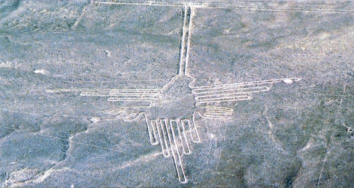
The hummingbird geoglyph.
What makes the Nazca lines one of the world's greatest mysteries is that nobody today knows why they were drawn. The first theory was that they were the remains of an ancient irrigation system, like the puquios. Then a North American professor and photographer, Dr. Paul Kosok (?-1959), came to examine the lines. On June 21, 1941, the day of the winter solstice in the southern hemisphere, Kosok happened to be standing on one of the lines, and he saw the setting sun touch the end of the same line. This gave him the idea that like Stonehenge, the Nazca lines were a type of calendar, set up to show the rising and setting points of important objects in the sky. Kosok passed on this theory to Dr. Maria Reiche (1903-98), a German-born mathematician and astronomer who devoted her life to preserving the Nazca lines and trying to learn their secrets. Unfortunately for Kosok and Reiche, more than one computer analysis has been run on the directions of the lines, and they reveal no more match-ups with celestial objects than we would have if the lines were plotted by chance.(37) A Peruvian archaeologist, Hans Horkheimer, made an alternate proposal in 1947, that the lines were used to mark a path of pilgrimage, for worshipers visiting the graves of their ancestors, but so far no graves have been found near any of the lines.
That was the situation when Erich von Daniken, the author famous for proposing that aliens had visited earth in ancient times, made his provocative proposal. To von Daniken the Nazca lines looked like airport runways, so in his 1968 book Chariots of the Gods?, he announced his theory that the desert was an ancient landing field; the Nazca Indians had seen spacecraft coming down like airplanes, and they drew more lines to encourage their “gods” to come back more often! Presumably the animal drawings were also done to please the gods, because only someone looking down from the sky could fully appreciate them. Unfortunately for von Daniken, there are huge holes in his theory, like the lack of an airport infrastructure around the “runways” (there is not even a windsock); nor did he explain why any spacecraft would need a runway forty miles long to come to a stop after landing. Therefore the “landing strip of the gods” theory is only popular among those who already believe in ancient astronauts (see footnote #2).
Like the Moche, the Nazca suffered badly from the floods of the sixth century. They made matters worse by cutting down the local trees, especially the mesquite called Prosopis pallida, to make room to grow more corn and cotton. The trees prevented wind and water erosion, so their removal meant that El Nino events would cause more trouble than they did previously. Around 750, the Nazca simply disappeared, and their domain came under the rule of the Huari. If any descendants of the Nazca survived the Huari and Inca conquests, they were killed in the crossfire between Spanish factions fighting over southern Peru in the 1540s. Thus, at this time the riddle of the Nazca lines is complete. Still, it may be solved in the future. As Maria Reiche put it: “One day we expect to decipher the puzzle, if God so wishes.”
![]()
The Magnificent Maya: The Early Classic Era
There's no question about it; the Maya civilization was the most spectacular to come out of Mesoamerica. Because of them, most textbooks will call the period of American history from 300 to 900 A.D. the “Classic era.” Although no Maya city would grow to the size of Teotihuacan(38), the Maya more than made up for that in their intellectual achievements. Nor did they invent writing, astronomy or the calendar, but they improved them to a degree that still astonishes us today.
There were three basic regions in the Maya domain:
1. The Petén, the already mentioned forested lowlands of northern Guatemala, southern Yucatan, and Belize. Most of the Maya communities from the
Pre-Classic and Classic eras were here, like El Mirador, Tikal and Palenque.
2. The southern highlands, which ran from Chiapa de Corzo to Copán. We already looked at one city here, Kaminaljuyu.
3. Northern Yucatan. If you ever go to the famous resort of Cancun, the nearest Maya ruins are located in this region. The cities here, especially Chichen Itza, were important in the Post-Classic era, but before that time, northern Yucatan was an underpopulated backwater, compared with the other two.
The Maya never had a central king ruling over an empire. Instead, they were divided into as many as twenty city-states. The four most important city-states during the Classic era were Calakmul, Copán, Palenque and Tikal; other cities worth remembering include Altun Ha, Bonampak, Caracol, Dos Pilas, Dzibilchaltun, Lamanai, Tonina, Uaxactun, Uxmal and Yaxchilan. Each major city had a king and nobility, supported by tribute from surrounding farms and those cities too small to keep their independence. Like the city-states of classical Greece, they had a common language and religion--and fought constantly.
Until the mid-twentieth century, historians and archaeologists talked about the Maya as if they were peaceful intellectuals, contrasting them with the bloodthirsty Aztecs. To them the Maya were the Greeks of the New World, and because the Aztecs came later, built a stronger state and did less thinking, they resembled the less cultured, more brutal Romans. Our anthropologists knew about the Maya practicing blood sacrifices, but noted they were not as common as they were among the Aztecs. However, a more complete picture of the Maya has been put together since then, starting with the 1946 discovery of a chapel at Bonampak, which had walls covered with beautifully preserved frescoes. Those murals commemorated a battle fought in 790, which resulted in the king of Yaxchilan installing a new king over Bonampak. There is nothing peaceful about the scenes; you see prisoners begging at the feet of their captors, and one of them, like the Zapotec Dazantes, is sprawled out as if he has fainted, or is dead. After that discovery, we also learned that the Maya were motivated by their religion to make war on each other (see footnote #25). Finally, while the Maya may not have sacrificed people to their gods very often, there were the previously mentioned bloodletting ceremonies, in which individuals offered up their blood, if not their lives. Today giving blood is safe and nearly painless, but the Maya did not have that luxury; their methods included running a barbed rope through a hole in the tongue, or piercing one's genitals with stingray spines. It now looks like people of all social classes did this at one time or another, but because the king's blood was the most valuable, it was shed the most often.
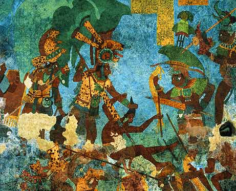
A typical Bonampak mural.
To all this, the author will point out that classical Greece was not a philosopher's utopia, either. Because the Greeks were also divided, they had just as much trouble getting along. The same civilization that gave us Homer, Socrates, playwrights like Sophocles and Aristophanes, and the concept of democracy, also gave us the Trojan War, the militant city of Sparta, the Peloponnesian War, and Alexander the Great. Likewise, in China the Age of Warring States produced both political chaos and great thinkers like Confucius. Great culture and great turmoil come together so often that when we see one, we should not assume the other wasn't there, too.
We already noted that the Maya had the most advanced system of writing in the New World.(39) Besides carving inscriptions in stone, they also wrote on paper made from tree bark, with they folded like an accordion to make a book. Unfortunately for us, the tropical climate of Mesoamerica makes it difficult to preserve books of any kind, and the Spaniards destroyed every Maya book they got their hands on, as part of their effort to stamp out the Maya religion.(40) Only four books escaped oblivion, and the first three to be found are now called the Dresden Codex, the Madrid Codex, and the Paris Codex, each named after the city that has it.(41) Eleven pages from a fourth book, the so-called Grolier Codex, turned up in Mexico in 1965. Because Mexicans have been manufacturing fake pre-Columbian artifacts since the outside world started buying them, many people believed this was a fake, until an intense examination, which included carbon-14 testing, concluded that the Grolier Codex was not only the real McCoy, but also two hundred years older than the other books.(42)
As for the calendar, it used several cycles of time, which intermeshed like a set of gears. We already saw the Long Count and Short Count cycles (see footnotes #18 & #22); to this the Maya added a lunar cycle, a Venus cycle, a Lords of the Night Cycle, and an 819-day cycle; unfortunately we don't know what the last two cycles were for. The end result was the most sophisticated timekeeping device of the ancient world. Certain gods were seen as reigning for a certain time period--a day, a month, a year or whatever--making those time periods favorable or ill-omened.
Without the benefit of telescopes, Maya astronomers calculated the length of the year more accurately than anyone else had, even more accurately than the European astronomers who developed the Gregorian calendar, so if they wanted to, they could have made their calendar more accurate than ours. Instead, their calendar ran on the assumption that a year was exactly 365 days long; no leap-year days were added or removed to correct that error. Maybe the Maya felt that their religion required them to leave their calendar alone; the traditional Islamic lunar calendar has just 354 days in a year for the same reason.
Like the calendar, the Maya religion was obsessed with cycles. Because they expected all events to repeat themselves over time, the elite believed that if they understood the past, they could predict the future, and that humanity must adapt to the cycles of the universe. At the end of a major cycle, either the 7,200-day K'atun or the 144,000-day B'ak'tun, a major, possibly earth-shaking event, was expected to happen; hence all the excitement in popular culture over a B'ak'tun ending on December 21, 2012. Besides making sure that the gods were pleased with human activity, the priests would interpret all the cycles in the calendar when making their prophecies, and determine the best times to plant crops and hold ceremonies like weddings.(43)
The Maya believed the universe was divided into three planes of existence: the earth, the thirteen heavens above, and the nine-layered underworld beneath, called Xibalba (place of fear). Heaven was reserved for women who died in childbirth and those who were sacrificed. Everyone else, even rulers, went to Xibalba, which like the Greek and Mesopotamian underworlds, was seen as a dreary place, dominated by death and decay.
Most of the Maya gods had to do with nature and agriculture, which makes sense in a society where most people are farmers. Many had both a friendly and a malevolent personality; “good” and “evil” were not permanent, opposite characteristics among Maya gods and heroes, they way they are in Western culture. Also, each god was complemented by a companion god, seen as a wife or husband to the first god. For us the Maya mythology can appear confusing, though it may be because we have an incomplete record, and thus don't fully understand it. That supreme god was Itzamná, the creator of man, god of the fire and god of the hearth. Other important gods included Huabku, the creator of the universe; Kinich Ahau, the sun god; Yum Kaax, the god of plants; Ix Chel, the goddess of childbirth; and Ah Much, the lord of death. Two gods from Teotihuacan, Quetzalcoatl and Tlaloc, were adopted into the Maya pantheon; and renamed Kukulkán and Chac, respectively.
The highest-ranked priest in the religious hierarchy, the Maya equivalent of a pope or cardinal, was called Ah Kin Mai, “The Highest One of the Sun”; the other priests were called Ah Kin, “The One of the Sun.” As with other theocracies, there were specialist priests devoted to activities like sacrifices, oracles, and calendar interpretation. The most important activities were the sacrifices, and while the Maya did make gentle offerings of flowers, incense, grain and drinks, those never got much attention; they felt they got the best results when they offered themselves. Besides bloodletting, this meant human sacrifice. More than one method was used (e.g., at Chichen Itza they threw victims into a cenote, a sinkhole filled with water), but the Maya are mainly remembered for developing the technique where four priests held the victim down on an altar, while a fifth priest cut open the victim's chest, tore out the heart, and offered it up to the god.
Finally there is Maya art, which followed rigid rules of representation, yet still managed to be flamboyant and realistic. The typical Maya scene shows high-ranked officials wearing costumes of incredible complexity, with headdresses as big as themselves; surrounding them are birds, flowers, vines, animals, glyphs and calendar dates, clustered together as if the scene is imitating jungle life. Most of the Maya art we have is in the form of sculpture, because few paintings have survived. Besides the Bonampak murals, the best examples we have of Maya painting come from the small vases they gave to each other on special occasions.
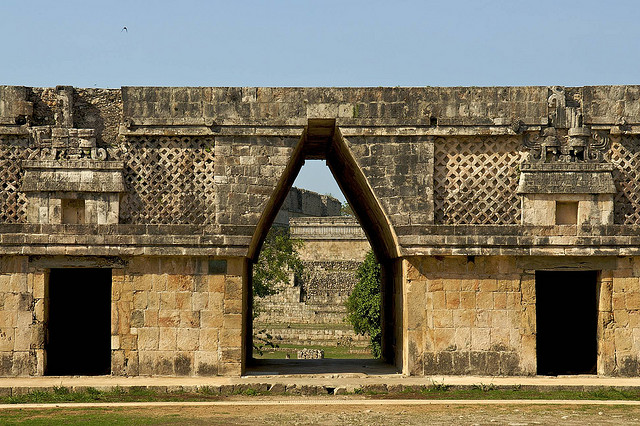
Here is a common feature associated with Maya architecture, the corbeled arch. Unlike the Romans, the Maya never mastered the true arch. This superb example comes from Uxmal.
Currently, writing a history of the Maya civilization is like putting together a jigsaw puzzle with some missing pieces; you hope you can make an accurate picture with what you have. Although we have a nearly complete list of kings for each city during the Classic era, for the first half of the Classic Era (300-600), we only have details about a few events, mainly ones involving the foremost Maya city, Tikal. Therefore you won't see this narrative say much about the cities where the only available data is the names and dates of kings; I trust the reader won't think I am biased toward Tikal if I talk more about that city than any other.
When we last looked at the Maya, we stopped at the point when Tikal started leaving records of its activities, in 292 A.D. One of the kings after Scroll Jaguar Lord apparently died without leaving an heir, because we have a report that when a K'atun (7,200-day cycle on the Maya calendar) ended in 317, one Lady Une' B'alam, acting as the queen of the city, led the appropriate ceremonies. She was succeeded by a king named Moon Zero Bird. We have a plaque showing this king holding a serpent, and out of the serpent's mouth come two gods, the sun god and the god of lineages, meaning he saw himself as the one who established or re-established legitimate rule. Also important, Moon Zero Bird is standing on a captive noble, who is struggling in an attempt to escape his fate. This tells us that the Maya were practicing human sacrifice again, and they saw their neighbors as the best source of victims. High ranking captives were more desirable offerings than peasants, and if a king was lucky enough to capture another king or prince, he would add their names to his own for the rest of his life. The nearest city, Uaxactun, must have been a frequent target of Tikal's raids, because from 328 onward, Uaxactun's kings also portrayed themselves as warriors, with captives cowering at their feet.
The rivalry between Tikal and Uaxactun took a new turn under Chak Tok Ich'aak I (Jaguar Paw I, 360-378). This king died on January 14, 378, and on the same day, a general from the west named Siyaj K'ak' (Smoking Frog) arrived in Tikal; it looks like he killed Jaguar Paw and took over. Two days later, Smoking Frog conquered Uaxactun, too. On the stela he erected at Uaxactun, Smoking Frog showed himself armed like one of Teotihuacan's warriors, with a large round headdress, a war club studded with sharp pieces of obsidian, and an atlatl--a hook-shaped device that was held behind a spear when thrown, to increase its range and penetrating power. Maya inscriptions state that Smoking Frog was under the authority of a ruler named Atlatl Cauac (Spearthrower Owl, 374?-439). This leads us to believe that Smoking Frog led an invading army from Teotihuacan, to gain control over the trade route that ran between Teotihuacan and Tikal. In the temple near the Uaxactun stela, archaeologists found the skeletons of five women and children; these could be the last members of the defeated royal family, killed by Smoking Frog after the battle. Within the same year, Smoking Frog crowned the son of Spearthrower Owl, Yax Nuun Ayiin I (Curl Nose, 379-404?), as the next ruler of Tikal, as as long as he was a minor, Smoking Frog kept an eye on him from his own throne in Uaxactun. After he grew up, Curl Nose would conquer the town of Rio Azul, 62 miles to the northeast, a move which gave Tikal access to the Caribbean.
Because they were a small minority, and a long way from home, the Teotihuacano ruling class could not keep its identity for long. By the mid-fifth century, they had been assimilated, becoming as Maya as their Maya subjects. Before that happened, though, they played the role of kingmaker once more. In the southeastern corner of the Maya-populated zone (western Honduras) were two small cities named Copán and Quiriguá. The lush valley containing Copán was first settled in 1100 B.C., but had been deserted for most of the time since 300 B.C., so Tikal's intervention here was really a re-founding of that city. In 426 a warrior from Tikal named K'uk' Mo' Ahau seized power in Copán, took for himself a wife from the former ruling family (which made him a legitimate ruler), and changed his name to K'inich Yax K'uk' Mo' (Great Sun First Quetzal Macaw). Like Smoking Frog, he appears in Maya art wearing a Teotihuacan-style costume. Three days later, he installed another warrior as king of Quiriguá, but almost nothing is known about him; scholars call him “Tok Casper” because one of the glyphs representing his name looks like a cartoon character, Casper the Friendly Ghost. For both cities, this marked the founding of new dynasties that would last for four centuries. K'inich Yax K'uk' Mo' and his successors were prolific builders, and by the end of the Classic era their combined efforts would make Copán one of the grandest Maya cities, a place whose ruins still impress visitors today.
Copán's builders were as likely to renovate old temples as they were to create new ones from scratch. The best example is the pyramid of Copán, which underwent seven major building projects and dozens of minor repairs and renovations. Previously there had been four temples on the site, but instead of tearing them down and clearing the rubble away, the workers carefully covered them up and built the pyramid over them. By digging tunnels into the pyramid, Ricardo Agurcia, a Honduran archaeologist, was able to explore two of the temples, which he named Rosalila and Oropendola; he also discovered a royal tomb beneath each temple. K'inich Yax K'uk' Mo' was the king buried under Oropendola, but the roof of the tomb under Rosalila had caved in, crushing everything inside, so that tomb's occupant has not been identified yet.
As the sixth century began and Teotihuacan's influence faded, a new rivalry broke out, this time between Tikal and a city named Calakmul. The latter was located 24 miles north of El Mirador; remember, El Mirador was the most important Maya city before Tikal came along. Apparently Calakmul now claimed its kings were the heirs of El Mirador, a declaration which challenged Tikal's supremacy. In response, Tikal claimed the authority of both El Mirador and Teotihuacan for itself, because Tikal's current line of kings came from the latter. Each of the two cities gathered allies, until the Maya realm was polarized between them, much like how the modern world was polarized between the USA and USSR in the twentieth century.(44) To distinguish themselves from the kings of lesser cities, the rulers of both Tikal and Calakmul chose a new title for themselves, kaloomte', which we usually translate as “high king” or “king of kings.” Unlike the Tikal-Uaxactun rivalry, the one between Tikal and Calakmul would last for 400 years, and as we will see later, one of the reasons why the Classic-era civilization collapsed is because these cities could not make a lasting peace.
The king of Tikal at the beginning of the sixth century, Chak Tok Ich'aak II (Jaguar Paw II, 486-508), was succeeded by a female ruler, who was simply called the “Lady of Tikal.” Presumably this queen was a daughter of Jaguar Paw II, and she took over because of another dynastic crisis, which would have happened if the previous king left no sons. Like the Byzantine empress Zoe, she shared power with her two husbands, Curl Head (511-527) and Bird Claw (527?-537?); each of them was king while he and the Lady of Tikal were together.
After this came a curious interruption; whereas the rulers of Tikal had been quite verbose previously, from 534 to 593 they left few records and raised few monuments. Some historians call this the “Tikal hiatis,” and for much of the twentieth century they wondered what caused it. Now it looks like Tikal suffered a severe downturn in its fortunes, caused by sixty years of bad weather and at least one military defeat. In the sections on the Moche and Nazca civilizations, we saw they were hit hard by floods and droughts between 535 and 594. Because those dates are only one year off from the dates for the Tikal hiatus, I would not be surprised if Tikal suffered from natural disasters as well. In addition, there was a war in the middle of the period, where Calakmul and another city, Caracol, were allied against Tikal. According to an eroded altar at Caracol, Tikal was defeated in 562, and its king, Wak Chan K'awiil (Double Bird), was captured and sacrificed; Tikal was not sacked, but some of its population may have been relocated to Caracol. Another king of Tikal, whose name has not been preserved for us, at one point had to take refuge with the king of Palenque, another enemy of Calakmul. If there were any other battles during the hiatus, Calakmul got the better of them, because that city's fortunes were riding high when the hiatus ended. For us, the Tikal hiatus is a convenient way to divide the early and late halves of the Classic era.
![]()
The Magnificent Maya: The Late Classic Era
Palenque
The Maya enjoyed their best years in the seventh century. However, unless your home city was Calakmul, it probably did not look like good times were just around the corner as the century began. After Tikal's defeat in 562, the western city of Palenque became Calakmul's main opponent in the wars between Maya states. In 599 the king of Calakmul, Uneh Chan, not only defeated the queen of Palenque, Ix Yohl Ik'nal, but also sacked the city. He captured Palenque again in 611, and the king of Palenque at this time, Aj Ne' Yohl Mat, died in the following year, perhaps because of that defeat. An interregnum followed, with the next king lasting less than a year, and he was succeeded by a daughter, Sak K'uk' (612-615), a sign that the king had no sons. Fortunately this queen had a son, K'inich Janaab Pacal, and he ascended to the throne in 615, though he was only twelve years old.
Because he got started early, Pacal ruled longer than any other Maya king, for sixty-eight years (615-683), and he accomplished so much that we now call him “Pacal the Great.” Besides restoring Palenque's strength and status as the most important Maya city in the west, he launched a great building program that produced some of the best examples of Maya architecture. He did this partly because he had inherited the kingship from his mother, so he felt the need to convince everyone that he was just as legitimate as kings who succeeded their fathers. Along this line, he left four king lists carved in stone in different parts of Palenque, that traced his lineage back to the year 431. In the chapel on top of his pyramid, the Temple of Inscriptions, Pacal carved an inscription that showed Sak K'uk' as First Mother, the mother of the other Maya gods, and he pointed out that his birthday fell on the same day as First Mother's birthday, too, as if these gave him a better claim to the throne than just hereditary rights.
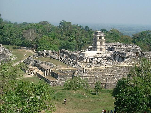
Palenque today.
Pacal was such an exceptional leader that he was deified when he died, and received the richest funeral found so far in Mesoamerica. His burial was found intact by a Mexican archaeologist, Alberto Ruz Lhuillier, when he discovered a secret door in the Temple of Inscriptions in 1948. Behind the door was a stairway going 73 feet down into the pyramid; because the stairway was full of rubble, it took four years for Ruz to clear it out, so he could descend to the burial chamber. In the burial chamber's sarcophagus was a skeleton adorned with a mask, bracelets, necklaces and rings, all made of jade.(45)
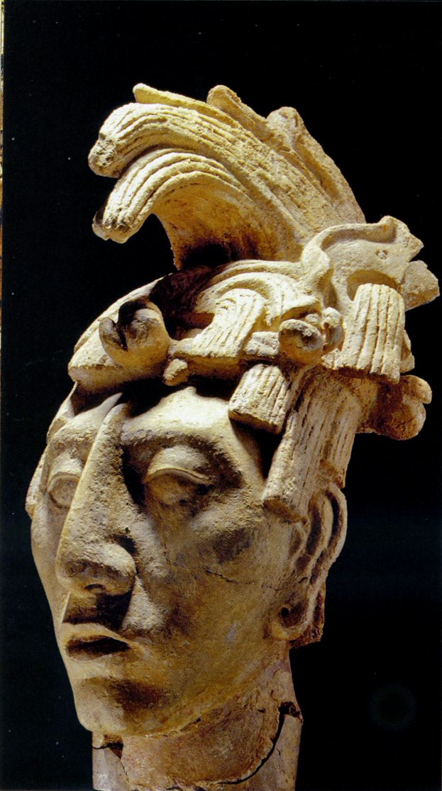
A bust of Pacal, showing how he looked when alive. Pacal's favorite god was a deity we call the Tonsured Maize God, so here he wears his hair to resemble a cornstalk.
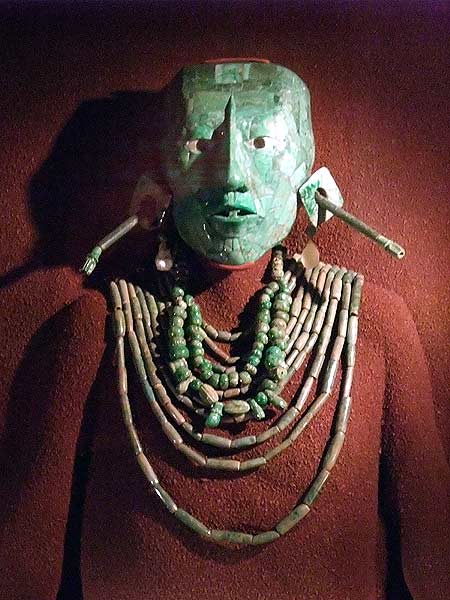
Pacal's jade treasures. From a travel log by Mark Horrell.
Although the next king, K'inich Kan B'alam II (684-702), was Pacal's eldest son, and thus legitimate in the eyes of everyone, he still conducted a campaign for legitimacy like his father did. In addition to conducting Pacal's funeral and completing his Temple of Inscriptions, he put lengthy inscriptions in each of the temples he built, telling the creation myth of First Mother next to other inscriptions that told how he became king. Particularly interesting are the pictures alongside the inscriptions, which show Kan B'alam going to the underworld of Xibalba, to receive kingly authority from his dead father Pacal.
At the end of the seventh century, the city of Tonina (in modern Chiapas) inflicted defeats upon both Palenque and Calakmul. In 711 it even sacked Palenque and captured its king, K'inich K'an Joy Chitam II. Palenque did not crown another king until 722; we do not know if K'inich K'an Joy Chitam II was executed, sacrificed, or held hostage after his capture. We also do not know if the next king, K'inich K'an Akhal Mo' Nab' III, was part of the dynasty of Palenque, or a ruler imposed on the city by Tonina.
This king, his son and his grandson enjoyed reigns of decent length, ruling until 799, but the war with Tonina continued; Tonina won at least one more victory. Palenque came under serious stress before the other Maya city-states did; the kings left fewer inscriptions and erected fewer buildings in the eighth century than they did in the seventh, and construction stopped altogether after 800. Now that Palenque was past its peak, it was swept into the crisis that struck the whole Maya civilization in the ninth century. Some farming families stuck around after the ruling elite disappeared, but by the time the Spaniards arrived in the sixteenth century, the peasants had also abandoned Palenque to the jungle.
![]()
Copán
Just as Palenque was the foremost city on the western edge of the Maya realm, and Tikal was the chief city in the center, so Copán was the chief city in the south. This city began the Late Classic era with a long-lived king named K'ak' Chan Yopaat (578-628, Smoke Serpent). The next king, Chan Imix K'awiil (628-695, Smoke Jaguar), did even better, with a reign that was only one year shorter than the reign of Pacal the Great. On the military front, he conquered surrounding land until the city controlled an area of more than a hundred square miles, and whereas most Maya kings performed their religious duties on top of pyramids or in plaza courtyards, Smoke Jaguar erected stelae which declared the whole valley of Copán as his place for communion with the gods. He was succeeded by Uaxaclajuun Ub'aah K'awiil (695-738, Eighteen-Rabbit). All three of these kings were prolific monument builders.
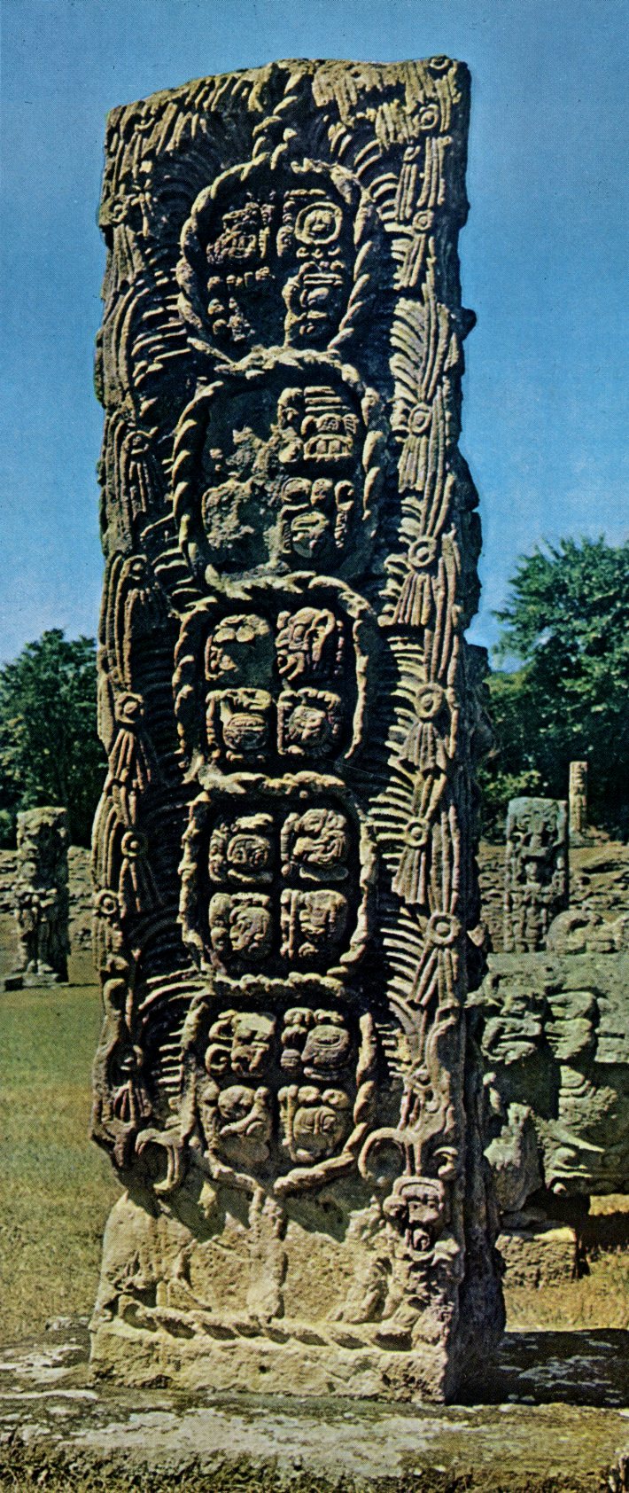
This stela from Cop�n, called Stela F by archaeologists, reports a meeting between Eighteen-Rabbit and a deity. Here we see the back side of the stele; the front shows a likeness of the king. The glyphs give a date of 9.14.10.0.0, which on our calendar works out to October 13, 721 A.D.
The reign of Eighteen-Rabbit saw Cop�n reach its peak, and it ended with a disaster which started the city's decline. In 718 he conquered and destroyed Xkuy, a city which has not yet been located; six years later he installed K'ak' Tiliw Chan Yopaat (724-785, Cauac Sky) as his vassal king in Quirigu�. However, this king would not stay subordinate; in 734 Cauac Sky erected an altar that called him k'ul ahau (holy lord), instead of just ahau (lord), a subtle declaration of independence from Cop�n. Next, because Cop�n was an ally of Tikal, he formed an alliance with Calakmul, the enemy of Tikal. What happened after that is unclear, but in 738 Eighteen-Rabbit was captured, taken to Quirigu�, and beheaded at the command of his former vassal. There is no evidence of damage to either Cop�n or Quirigu� at this time, so it does not look like a battle took place between the cities. In addition, Quirigu� only had a tenth of the population and resources that Cop�n did, so if matters came to war, all the advantages would have been with Cop�n. We do know that Eighteen-Rabbit finished building a new ball court in Cop�n right before his luck ran out, so currently the theory is that he left the city, looking for victims to sacrifice at the ball court's dedication, and fell into an ambush from Quirigu� instead. Though Quirigu� could not beat Cop�n in a one-on-one fight, Calakmul could send aid to keep Cop�n from conquering Quirigu�, and that appears to have allowed the latter city to keep its independence.
The loss of its king was a terrible setback, and Copán never got over it. The next king, K'ak' Joplaj Chan K'awiil (738-749, Smoke Monkey), built nothing at all, and his successor, K'ak' Yipyaj Chan K'awiil (749-763, Smoke Shell or Smoke Squirrel), did not build anything until 755. His main achievement was to enlarge the stairway on a pyramid built by Eighteen-Rabbit and cover it with glyphs, making it the longest Maya inscription found so far. The inscription was a list of the previous fourteen kings, with the dates of their reigns as well as their names. Unfortunately the “Hieroglyphic Stairway” and the whole side of the pyramid were not held in place with lime or mortar, but simply built on top of loose earth, suggesting that the nobles and/or workers did not back the king in this project, or that the city could no longer afford to do it right. Thus, after the Classic era ended, most of the stairway collapsed; only the bottom fifteen steps remained in place, forcing today's archaeologists to guess at where the other stones belonged (it doesn't help that many of the glyphs on the stones are eroded). Meanwhile, Quiriguá built monuments of its own, suggesting that it took tribute from Copán during this time.
The 16th (and probably last) king of Copán's dynasty was Yax Pasaj Chan Yopaat (763-820?), better known as Yax Pac. He came to the throne at the age of nine; his mother was a noblewoman from Palenque, and he barely mentions his father in inscriptions, leaving us wondering if he was descended from the previous king. It appears he faced a serious challenge from the city's nobility, because evidence for a decentralized government has turned up; in the late eighth century, Cop�n's territory was divided into twelve administrative districts, each run by one of Yax Pac's advisors, and Yax Pac built palaces and shrines to noble families, something previous kings weren't inclined to do. The reason for this may have been a poor economy, like the hard times that forced the builders of the Hieroglyphic Stairway to cut corners. We have a good idea of what caused this--environmental damage. The local population reached a peak of 28,000 in 775, and the soil was ruined from too much deforestation, farming and erosion, so it could not feed all those people. Cop�n's building projects were to blame, too; they consumed much of the arable land, and forced the peasants living on it to move to the slopes of mountains, where farms were far less productive. Skeletons found at Cop�n from the late eighth/early ninth century show diseases caused by malnutrition, like rickets; as much as 90 percent of the population could have suffered from these ailments.
A resource-poor city can prosper when it can import what it needs from elsewhere, but it looks like Copán could not produce enough goods to pay for those imports. In 802 Yax Pac set up a monument in Copán to let everyone know that he had reigned for two complete K'atuns, but when the current K'atun ended in 810, he performed the ending ceremony in Quiriguá instead. In other words, Yax Pac's concessions to the nobility did not win him enough support from his subjects to stop the city's decline.
The tomb of Yax Pac had sculptures of the king performing war dances with a spear and shield, a hint that his last days saw violence. A sculpted column from the same time has an inscription which talks about the "toppling of the Foundation House," which we take to mean that Cop�n's dynasty had been overthrown, after ruling for four hundred years. In 822 someone named Ukit Took carved on an altar that he had "acceded," but it's not clear if he was claiming to be a king. Indeed, the altar wasn't even finished, so Ukit Took could not have been in charge for long. After that inscription, the scribes of Cop�n fell silent. By 900 the city's elite were gone, and while several thousand villagers remained in the neighborhood until at least 1000 A.D., all they did was farm a few acres on the site, and remove some of the stone from Cop�n's monuments to build their own houses. As with Palenque, eventually even the farmers moved away, and the only visitors to Cop�n after that were a handful of pilgrims, who stopped by to pay homage at a shrine, or leave an offering on the ruins.
![]()
Tikal and Calakmul
The Tikal-Calakmul rivalry continued into the seventh century, with Calakmul on top in the early years. From Calakmul we have vague inscriptions concerning a city named Naranjo; it appears that Naranjo tried to leave Calakmul's alliance in 623. The king of Calakmul defeated Naranjo twice in 626, and finally crushed the rebellion in 631. Whatever happened to Naranjo's king must have been hideous; the texts reporting that king's capture include the word k'uxaj, which means either “tortured” or “eaten.”
It took most of the seventh century for Tikal to recover from its sixth-century slump. In 629 the current king, K'inich Muwaan Jol II, founded Dos Pilas as a military outpost, sixty-eight miles to the southwest, and six years later he installed his four-year-old brother, B'alaj Chan K'awiil, as the new city's first king. However, this did not give Tikal an advantage over Calakmul. From 636 to 686 Calakmul was ruled by its greatest king, Yuknoom Ch'een II. This king took Dos Pilas in 648, but instead of getting rid of B'alaj Chan K'awiil, he reinstalled him as Calakmul's vassal. Then in 657 Calakmul and Dos Pilas attacked Tikal together, forcing Tikal's current king, Nuun Ujol Chac (650-679, Shield Skull), to temporarily abandon the city. B'alaj Chan K'awiil claimed the throne of Tikal for himself, but instead of moving, he stayed at Dos Pilas. However, Tikal turned the tables on its former vassal by attacking Dos Pilas in 672, and drove B'alaj Chan K'awiil into exile for five years. He came back at the head of an army from Calakmul, and in 679 Calakmul and Dos Pilas defeated Tikal once more; the hieroglyphic inscription commemorating this victory just says there were puddles of blood and piles of heads.
On other fronts, Naranjo defeated Caracol, an ally of Calakmul, in 680, but two years later the king of Naranjo died childless. It looks like Yuknoom Ch'een II of Calakmul intervened to put a pro-Calakmul dynasty on the throne, because a daughter of B'alaj Chan K'awiil, Ix Wax Chanil Ahau (Lady Six-Sky), was sent to marry the man who became Naranjo's next king. Yuknoom Ch'een also installed K'inich B'alam (Sun-faced Jaguar) as king of the city of El Peru, enthroned at least two kings at Cancuen (a trading center in the Petén, don't confuse it with Cancun), crowned another king at the western city of Moral, and got Motul de San Jose, an ally of Tikal, to switch to Calakmul's side. In all these activities the ultimate goal was to encircle Tikal with a network of pro-Calakmul states.
The next king of Tikal was that city's greatest. Ruling from 682 to 734, his official name was Jasaw Chan K'awiil I, but we know him better by his delightful nickname of Ah Cacao, Lord Chocolate. He began his reign by building Tikal's first dated monument in 120 years, the beginning of a grand building program that would continue until the early ninth century. Chief among Ah Cacao's works were two pyramids, the first of five pyramids that would go up at Tikal in the eighth century. Now called Temple I and Temple II, these structures stand more than 140 feet high and are capped with stone combs to make them look even more impressive. Like Pacal of Palenque, Ah Cacao had one of the temples double as his tomb; his skeleton, adorned with jade, pearls and shells, was discovered under Temple I in 1961.
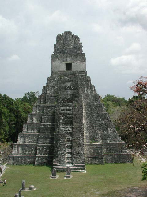
Temple I at Tikal, sometimes called the Temple of the Great Jaguar.
Ah Cacao was a soldier as well as a builder. Calakmul at this time was ruled by Yuknoom Yich'aak K'ak' (686-695, Jaguar Paw Smoke), and in 695 Ah Cacao captured him in battle; he also captured the image of Yajaw Maan, a god of Calakmul. This defeat was so catastrophic that it permanently crippled Calakmul, and Tikal regained its status as the chief Maya city, except in the southwest Petén, where Dos Pilas remained independent and even expanded the area it controlled, under the unnamed successors of B'alaj Chan K'awiil. Calakmul turned its attention to the south, where as we saw earlier, it supported Quiriguá in its bid to keep independent of Copán.
Ah Cacao's successors continued to build monuments, but they left few inscriptions; like Palenque, Copán and Calakmul, the strength seems to have gone out of Tikal by the end of the eighth century. What energy they had was diverted from temples to fortifications; after 750, Maya building projects included moats, walls and fortresses. At Dos Pilas, one wall ran right through an old palace and over a glyph-covered stairway; other cities pulled cut stone off the temples to use in their defenses, showing how great the need was for further protection.
Dos Pilas was destroyed in 761, and the four cities it controlled became independent. One of those cities was Aguateca. In this scene, Aguateca is under attack, and Tan Te' K'inich, the city's last king (770-802), hides his treasures before fleeing. But he never came back for them, falling in battle instead.
830 was the end of a B'ak'tun, the longest cycle on the Maya calendar, but no monuments were built in either Calakmul or Tikal to mark the event, suggesting that the governments of both cities had unraveled to the point that they were unable--or just didn't bother--to celebrate it. Some of Tikal's satellite cities began using the mutal emblem (see footnote #44) for themselves, meaning they had declared independence. The last monument erected at Tikal was a stela dated 869; by 889 Tikal's ex-vassals had also raised their final monuments. At its peak, Tikal had 40,000 people, and after that depopulation followed the same pattern that it had at Palenque and Copán. The upper class was the first group to go, and squatters took their place in the plazas, temples and palaces, using those buildings with much less formality than the previous owners did. By 950, the squatters were in turn succeeded by a community of peasants living in huts alongside the buildings; by 1100, these residents also deserted Tikal, turning that city into another set of overgrown ruins.
The last Maya monument with a Long Count calendar date on it went up at Tonina, in 909. For us the date is a convenient ending point for the Classic era, just as we began the Classic era with a Long Count calendar date from Tikal.
![]()
The Collapse of the Teotihuacan and Maya Civilizations
The Maya were going great guns when their big neighbor, Teotihuacan, crashed and burned. Because the Teotihuacanos were still illiterate, we can only speculate on how the trouble started. Did the population outgrow the ability of the farmers to feed it? Was there a political crisis? Famine caused by crop failure? Did they wear out the land from bad farming practices? Because Teotihuacan's buildings were coated with lime plaster, a lot of firewood must have been burned for lime production; the Teotihuacanos could have cut down too many trees for firewood, causing erosion on previously forested hills. Remember, it has been suggested that this kind of land mismanagement caused the fall of El Mirador in Pre-Classic times. And did Teotihuacan's fall start a domino effect that brought down the Maya system?
We may not know how Teotihuacan's decline started, but we know how it ended; the city was suddenly destroyed by fire. Still, we don't know who did it, or why. We're not even sure of the date; archaeologists used to think the destruction came around 750, but recently some have proposed an earlier date, between 600 and 650. For a while it was thought that an outside invader, like the Chichimecs of northern Mexico, was responsible, until it was pointed out that most of the damage was inflicted on buildings and houses along the Avenue of the Dead, suggesting a popular uprising against the city's elite. Moreover, survivors of the fire abandoned the city instead of trying to rebuild, and nobody else moved in; in the aftermath, nearby cities like Cholula, Xochicalco, and Cacaxtla tried to take Teotihuacan's place. By the time the Toltecs arrived in the neighborhood, even memories of the great city had begun to fade.
As mentioned earlier, one of the biggest mysteries in archaeology is what caused the Classic era Maya civilization to fall. This has generated controversy in recent years, especially since Mel Gibson made a movie on the subject (“Apocalypto”). Part of the reason is that this civilization checked out so soon after its zenith. Most of the decline occurred within a century and a half (750-900), meaning it was short and steep, compared with the decline of other civilizations (e.g., it took the Roman Empire 1,273 years to fall, if you count from the death of Marcus Aurelius to the Turkish conquest of Constantinople). Moreover, this isn't the only ancient American civilization to suffer a mysterious ending, as the reader knows by now. Did the Classic Maya make the same mistakes that brought down the Olmecs and the pre-Classic Maya?
We know the immediate event behind the fall of the Maya--severe depopulation. Between 830 and 930, population in the Maya realm dropped by at least a third. With fewer farmers, workers and taxpayers, the government could no longer provide the services expected of it, or maintain all the structures it had built; it also had fewer soldiers to defend the cities. For us, the big question is what caused the population to take a dive. We saw that malnutrition/famine were a real problem in the second half of the Late Classic era (some call this time the “Terminal Classic” period), but most civilizations are able to weather that and move on. Some other calamity must have hit the Maya at the same time, knocking them down with a one-two punch.
According to Wikipedia, modern scholars have come up with eighty-eight theories to explain the Classic Maya collapse; not as many theories as those surrounding the decline and fall of Rome, but it's still a lot. Most look for a natural cause as the trigger. These include a natural disaster like an earthquake, hurricane or volcanic eruption. Climate data, derived from the study of tree rings, sediment cores, etc., shows evidence of severe droughts in the Petén between 800 and 1000, so now there is also a drought theory, which says that the dry years were more than the Maya irrigation and water storage systems could handle. In addition, a catastrophic epidemic has been suggested; we will see in the next chapter how epidemics killed more Americans in the sixteenth and seventeenth centuries than the military campaigns of the Europeans. And we already mentioned overpopulation and damage to the environment. Others have looked for an economic cause, like a breakdown in the Mesoamerican trading network. Still another possibility is a loss of faith; when crops failed or the city-state lost a battle, the kings thought more bloodletting and sacrifices were needed, and when they did not work, the peasants stopped fearing the upper class that demanded so much from them; with that spell broken, a revolt was likely to follow.
The Balkan wars of the 1990s suggested to many that like Yugoslavia, the Maya came to a violent end. According to this theory, their frequent wars to get sacrificial victims got out of hand, and became total wars, until the Maya city-states clobbered each other out of existence. In that sense, the military history of the Late Classic era was like the military history of Europe after Napoleon; for ninety-nine years European wars were short and not very bloody, so when World War I erupted, Europeans expected it to be another “genteel war,” but instead they wrecked their continent. Currently this looks like a better explanation for what happened, but it makes us ask one more question: Why did the wars escalate? Did a shortage of an important resource, like food, farmland or water, raise the stakes? If so, this brings us back to the other theories about what caused the decline. Or did society simply become less polite, when the city-states stopped observing whatever rules for fighting they had observed previously? Did Maya warriors have something like a code of chivalry, which limited destruction as long as they obeyed it?
In one way we exaggerate what happened. It wasn't a total collapse, inasmuch as the Maya people did not die out. Though anarchy followed when the upper class disappeared, ordinary Maya soon found out that they did not need a pyramid to worship the gods, so the main purpose for the cities became irrelevant. As for the astronomical function of the old buildings, well, if you are a farmer and all you need to know is when to plant your crops, some advice from an experienced neighbor will be just as helpful. Today's Maya still live in Yucatan, Guatemala, Belize and the nearest surrounding areas, and they speak twenty-eight languages derived from the ancient tongue. We will see them in one more section of this chapter, and they will appear briefly in the next chapter; Spain did not conquer all of them until 1697. Indeed, one archaeologist, Edward Wyllys Andrews IV, said this about the collapse: “In my belief no such thing happened.”(46)
![]()
Tribes of the Caribbean
For the pre-Columbian history of the Caribbean, we have even less to go on than we do with the illiterate tribes on the mainland. The natives of the islands had no nations or empires; they did not even build cities. Any modern tourist can figure out why. Like Hawaii and Tahiti, the Caribbean is a tropical paradise that many folks dream of retiring to someday. You've seen pictures of the beaches and resorts; you've heard songs like Bobby Bloom's “Montego Bay” and “Kokomo” from the Beach Boys. And once you have a comfortable home in such a place, why would you want to build anything else? Still, these were the people who made Columbus famous, and this website promises to tell the history of as many people as possible (“the rise and fall of just about everybody”), so here goes.
The names to remember for the Caribbean tribes are Ciboney, Taino, Arawak and Carib. It's a safe bet that they lived on the mainland originally, and got to the Caribbean by building dugout canoes and going island-hopping; each island they discovered became a base to use when looking for the next one. The Taino, Arawak and Carib speak languages related to tribes on the South American mainland, so we believe they entered the Caribbean from Venezuela, and the string of little islands that make up the Lesser Antilles were their first stops on the way. As for the Ciboney, the most primitive tribe, we used to think they came from Florida via the Bahamas, but so far no evidence has been found of any human activity in the Bahamas before 500 A.D., so now we believe they came from Venezuela, too.
The Ciboney were the first tribe(s) to arrive, reaching the Greater Antilles(47) and the Virgin Islands no later than 1000 B.C. These folk had a simple tribal organization with no permanent villages, and lived by hunting, gathering and fishing. When the Taino entered the Caribbean, they displaced the Ciboney from most of the land they had settled; by the time Columbus discovered the Ciboney, they were confined to Hati and western Cuba. Actually “Ciboney” is a Taino word meaning “cave-dweller”; the ones Columbus met called themselves Guanahatabey. Unfortunately the Europeans did not understand their language, and the Ciboney-Guanahatabey became extinct before anyone could translate it.
Strictly speaking, the Arawak lived in modern Guyana and Trinidad, while the Taino lived in the Greater Antilles, but the two tribes were so similar that the names are used interchangeably. Indeed, some people who claim descent from these Indians will call themselves “Taino-Arawak.” For the sake of convenience, we will call both tribes “Arawakan.” Whatever name you want to use, they migrated into the Lesser Antilles around 100 A.D. Within a hundred years they reached Puerto Rico (the Taino name for that island is Boriken); by 650, they had spread to Hispaniola and Jamaica, and would soon be settling eastern Cuba.
Like the Maya, the Arawakans created raised fields for agriculture. This gave them an economic advantage against the Ciboney; they could keep their villages in one spot and not worry too much about the food supply running out. The two most important crops were root vegetables, manioc and sweet potatoes. They also grew corn, beans, squash, peanuts, cotton, tobacco and pineapples, but with these crops, they were just as likely to use the slash-and-burn method as they were to plant them in raised fields. For meat, they ate fish most of the time, with an occasional turtle, manatee, hutia (a local rodent), earthworm, iguana or bird.
Most of their villages had between one and two thousand people, and the largest were home to three thousand. Both men and women could become chiefs; the chief of a village was called a cacique if male, cacica if female. In the time of Columbus, the Taino had five chiefdoms on Hispaniola, and seventeen on Puerto Rico. Their religion was centered around zemis (also called cemis), a term which can mean gods, ancestral spirits, and the images they made of these supernatural beings.
Compared with other tribes, the Arawakans were relatively peaceful. The only reasons they had for starting a war were to avenge a murder or to settle hunting/fishing rights. That is why they greeted Columbus wholeheartedly at the first American-European encounter. However, they had a fierce neighbor, the Caribs (see below). If the Spaniards had not come along to enslave the Arawakans and destroy their way of life, the Caribs probably would have eaten them up, literally; I will let the reader decide which is the worse fate.
Arawakan villages produced pottery, wooden bowls, and fishing equipment for trade. They also panned a little gold and copper out of the rivers, which they made into jewelry. In the end this was their undoing, for when the Spaniards saw the gold, they not only found ways to take it, but also impressed natives to dig more out of the gold fields. As we will see in the next chapter, the Spaniards were afraid because in the 1490s and early 1500s, the natives outnumbered them in the islands, so they used any excuse to attack and enslave whole villages; sometimes they caused disputes to justify their cruelty. Those who did not fall victim to Spanish weapons and slavery were easy prey for the diseases the Spaniards unwittingly brought from the Old World. Thus, the Caribbean became ground zero in the first holocaust inflicted on the non-European world by Europeans. Smaller islands that Spain chose not to settle were completely depopulated. A few thousand Arawak survive on the South American mainland, but the only Taino remaining are of mixed ancestry, descended from those Taino who married Europeans or African slaves. Nearly everything we know about these tribes comes from the handful of artifacts they left, and the first-had accounts of Spanish explorers, conquistadors and missionaries.
The Caribs entered the Lesser Antilles around 1200 A.D. They had a similar culture to the Arakwakans and their relatives who stayed behind in South America, but unlike both of them, the Caribs were very warlike. Internal conflict was common in their communities; men strove to be great warriors and they boasted of their heroic feats. The only men who were not expected to fight were the shamans (called buyeis), whose job it was to make medicines from herbs and cast spells against an evil spirit named Maybouya. Because of their skill with arms, the Caribs had conquered the Lesser Antilles from the Arawakans, one island at a time, and Puerto Rico was about to become their next target when Columbus arrived. They attacked the Taino mainly to get women, which they considered to be the most valuable commodity of all. In fact, they captured so many Taino women that in many Carib communities, the sexes spoke different languages.
Obviously the Caribbean got its name from the Caribs; the word “cannibal” comes from them, too. Women were not the only objective of Carib raids; they also hunted human captives to eat in their rituals. They did not do this because they were hungry; they believed that if they ate part of a brave warrior, they would gain his courage. Needless to say, this custom gave the Spaniards one more reason to kill, enslave, rip off, and convert the Caribs. Consequently, they stopped practicing cannibalism within a few decades of meeting the Europeans, not because they disliked white meat, but because the practice provoked wars they couldn't win. Although they held out longer on their islands than the Ciboney and Arawakans did, their warriors were no match for European soldiers, not only because of the technology gap, but also because of different objectives; the Caribs fought to capture their enemies, alive or dead, while the Europeans fought to kill as many enemies as possible, and to impose their will on the survivors. In the next chapter we will discuss at length why this made a difference, and how Spanish strategy, more than Spanish arms, Spain to conquer the New World's greatest empires.
The Carib language has been extinct since the 1920s, but a community of 3,000 Caribs survives on the island of Dominica, in a reservation called the Carib Reserve. A larger community of 600,000, known as the Black Caribs or Garifuna, are descended from Caribs who intermarried with African slaves. They resisted the Europeans until 1795, when the British relocated them to Roatan, a small island north of Honduras. Today most of the Garifuna live on Central America's Caribbean coast, but a few have returned to St. Vincent and Dominica, while others have immigrated to large cities in the United States.
![]()
The People of El Dorado
The first South Americans had to pass through present-day Costa Rica, Panama, Colombia and Ecuador to get to Peru and the Amazon basin, so it is no surprise that this region has been occupied by indigenous people since the dawn of history. However, for the same reason that we have to do a lot of guesswork concerning the tribes of the Caribbean (no important nation or written records), there aren't many facts to report on the tribes of the isthmus and northern Andes until a few decades before the Spanish arrival.
Several tribes occupied the jungles and mountains between Mesoamerica and Peru. They included the Diquis in Costa Rica; the Cocle in Panama; the Quimbaya and Tolima, who lived in parallel valleys of Colombia, separated by mountains; the Muisca in the central highlands (where modern-day Bogota is located); the Sinu in Colombia's northern plains and swamps; the Tairona in the northern mountains; the Calima, a collective name for several cultures on Colombia's west coast; the Nariño and Tumaco in southwestern Colombia; and the Cayapa, Colorado and Canar in Ecuador. Wherever the location, these tribes lived in wood houses with stone foundations, sometimes in communities large enough to be called towns. The most important thing to remember is that all of them were talented goldsmiths; as early as 1500 B.C., they were smelting gold and shaping it into exquisite decorations.
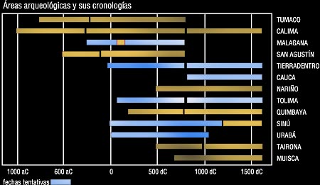
A bar graph listing the cultures of Colombia and showing their start and end dates. The dates on the blue bars are educated guesses. In Spanish, aC=B.C., and dC=A.D., so those tribes with gold bars extending all the way to 1500 lasted long enough to meet the Spaniards. Source: Genesis Gems.
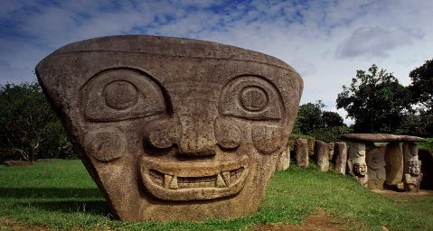
Some of the tribes in this region also left intriguing sculptures. The Diquis made hundreds of nearly perfect stone spheres, ranging in size from a few inches to nearly seven feet across. One can only guess at what these globes were meant to represent. Even more interesting are the incredibly expressive giant statues at San Augustin, a national park in southern Colombia. This picture features one of the three hundred San Augustin statues, and was posted at Bing.com on November 19, 2010. We estimate they were carved between 100 B.C. and 800 A.D.; nobody knows who did them, or why.
Spain became interested in this region because of a legend about El Dorado, “the Gilded One.” According to this story, the chief of the Muisca tribe would make an offering to a god by covering his body with a sticky substance like turpentine, sprinkling gold dust on top of that, and then washing it all off. The oldest account we have, dated 1531, does not say where the chief washed at the end of the ceremony; later accounts had him diving into a lake from a raft, as the other people on the raft threw in objects made of gold and emeralds behind him (many of the world's finest emeralds come from Colombia). The accounts also disagreed on whether the chief only performed the El Dorado ceremony at the beginning of his reign, or at least once every year. It now looks like the Muisca quit practicing this rite before 1500; no Spaniard gave an eyewitness account of it. Still, it excited the European imagination, as all stories about gold did. Eventually the Spaniards identified the lake in question as Lake Guatavita, thirty-five miles northeast of Bogota. Since the sixteenth century, several attempts have been made to drain the lake (all unsuccessful, except for one effort that caused the muddy lake bottom to harden like concrete), and while the various engineers and divers never recovered a king's ransom in gold and jewels, they found enough to confirm that a true story existed behind the legend.
Of course that story was exaggerated over the years as people retold it. And it didn't stop when the storytellers turned the offerings in the lake into a sunken treasure hoard. By the 1540s some believed that El Dorado was a city of gold, or even a country where golden images of plants and animals were as common as living ones. That gave them the idea that El Dorado may exist elsewhere, especially in the Amazon basin, when the treasures found in Colombia did not live up to expectations.
Over the ages, the tribes developed several ways to work with gold. Though their tools were simple, the pre-Columbian goldsmiths succeeded in mastering virtually every technique used in the Old World before the Industrial Revolution. One of the most popular was to hammer gold into sheets, which meant they also learned annealing to keep the sheets from becoming brittle, and a technique called repoussé for stamping patterns into it. Another was to mix gold with copper to make tumbaga, an attractive pink alloy, or add silver or platinum(48) to the gold to make it stronger. In addition, the goldsmiths were familiar with the lost-wax method, soldering, sweat welding, pinning, stapling, lacing with gold wire, inlaying, and plating objects like wood or whale's teeth. They even knew enough chemistry to practice electrochemical replacement plating, which allowed them to change gold's color and surface texture, and depletion gilding, which gave a perfect gold luster to objects which had an actual gold content as low as 15 percent.
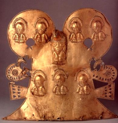
A Muisca pectoral, just a sample of the goldwork the Colombian tribes made.
Though we have been talking about precious metals in this section, do not forget that pre-Columbian Americans considered them precious for different reasons than the Old World did. To the Europeans, gold and silver had been the medium of exchange for centuries because they were pretty, rare, and inert enough that pure nuggets could be found in nature, meaning that instead of rusting or corroding, those metals lasted almost forever. They also used copper, though that was more common and less durable; indeed, with all three metals, most of what has been mined, panned and smelted over the ages is still in circulation. Native Americans, on the other hand, never had a money-based economy, so barter was always the form of exchange when they traded. To them gold and silver were not valuable because they were rare, but because they reminded them of the gods; gold was called “the sweat of the sun,” and silver was “the tears of the moon,” so an Inca king wearing a gold crown was supposed to resemble the sun. Everywhere the native economies valued labor more than whatever happened to be scarce; the Incas, for instance, prized cloth highly if the patterns on it required enough work. This difference in values would be the main reason for the misunderstandings that occurred when the peoples of the New and Old Worlds met--but that's a subject for the next chapter.
![]()
Tiahuanaco, the City of the Altiplano
Lake Titicaca is one of the world's natural wonders, being both the largest lake in South America and, at more than two miles above sea level, the highest commercially navigable lake anywhere. Nine miles from the lake's Bolivian shore are the ruins of Tiahuanaco (also spelled Tiwanaku), which has been called the world's most mysterious lost city. One would not expect a city to be built on this cold, treeless plateau, but the locals found several natural advantages to this site. For crops, they grew cool-weather plants like potatoes, quinoa (see footnote #5), and a root vegetable called the oca, which resembles sweet potatoes. Like the early inhabitants of Southeast Asia, they learned that they can grow crops on the hills if they terrace the slopes. They also developed an even more ingenious farming system; in Lake Titicaca itself, they heaped up sludge to form mounds, which they called suka kollus, and ran shallow canals between the mounds. Not only did the lake provide more water than what could be provided where the fields were high and dry, but the water also acted as a thermostat, absorbing the sun's heat during the day, and letting it out at night. This prevented crop damage from an out-of-season frost, which can happen often at high altitudes.(49) The resulting yields were even better than what modern agriculture, with its chemical pesticides and fertilizers, can do. Whereas simple agriculture in the fields produced a typical harvest of 2.4 metric tons of potatoes per hectare, and modern agriculture in the same fields produced a yield of 14.5 tons, farming in the “flood-raised fields” produced an awesome 21 tons per hectare.(50) In addition, the locals fished in the lake, and the nearby pastures were the best place in South America to raise llamas and alpacas, giving Lake Titcaca's residents a monopoly on livestock breeding.
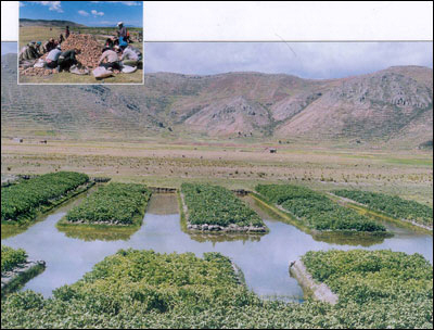
Lake Titicaca's answer to the floating gardens of central Mexico.
Tiahuanaco's site has been inhabited for a long time, at least since 1600 B.C.; radiocarbon tests, however, put most of the activity during the Middle Horizon period (600-1000 A.D.). But testing for carbon-14 is only relevant for organic matter; there is no way, even remotely accurate, to date Tiahuanaco's stones. It would have helped if Tiahuanaco's residents had left inscriptions on the rocks for us to read, the way other civilizations did, but as we pointed out more than once already, nobody in pre-Columbian South America had an alphabet or hieroglyphic script. Many of the buildings were found buried six feet underground, and that has led to all kind of speculation about when they were really carved; some writers have suggested they were cut 12,000 to 14,000 years ago. Others have asserted that Lake Titicaca's basin never could have supported as many people as Tiahuanaco had at its peak (population estimates range from 15,000-30,000 to 285,000-1,482,000 inhabitants), so the local climate must have been drastically different. Therefore the conclusion some make is that the elevation of this region was once much lower, until a catastrophic uplift left the city high and dry (literally), or that Tiahuanaco is a city from an advanced lost civilization like Atlantis, or that it even pre-dates Noah's Flood.(51) Myself, I think that is an exaggeration of the facts. Any city that is truly Antediluvian or Atlantean in origin is likely to have more than a few feet of dirt on top of it. As for the harshness of the environment, we will see below that Tiahuanaco had a trade network, so some of its food could have been imported. Finally, changing climates could have been a factor, the way it has been for some other civilizations we looked at in this chapter. Tiahuanaco reached its zenith during the so-called “Medieval Warming Period,” a time when world climates were generally warmer and more pleasant than they are today (800-1200 A.D.), meaning that a thousand years ago, the suka kollus farms could have yielded more bountiful harvests than they do now.
We saw that another culture, the Pukara, existed around Lake Titicaca before 300 A.D., and suggested that Tiahuanaco sprang from it. Whatever its origins, Tiahuanaco began expanding its influence into the nearest parts of Bolivia, Peru and Chile around 400. The residents of the Altiplano had two motivations to expand, commerce and religious zeal. To make sure they controlled important raw materials, colonies were established near their sources; caravans of men and llamas were also sent out to trade with communities beyond Tiahuanaco's control. The most common trade goods were the same as those carried on Chavin trade routes: corn, seashells, tropical feathers, medicinal plants and coca. The most important of those communities were those of the Huari (see below), who had a powerful state 600 miles to the north. By 800 Tiahuanaco-style ceramics were common throughout the southern Andes (Bolivia, Paraguay, Peru, and the nearest parts of Chile and Argentina), showing that Tiahuanaco controlled or traded with the entire region.
The chief god of Tiahuanaco was shown crowned with sunbeams and holding a staff in each hand, so he is called the Staff-Bearing God. The symbolism is no surprise; older South American civilizations had portrayed both gods and shamans as individuals of authority, by giving them a staff to carry.(52) Sometimes the staff was made to appear as a snake or cornstalk. Whatever they thought of their god, they spread the word about him to others. This missionary effort paid off when they converted the Huari, around 600. We do not believe the Tiahuanaco religion was imposed on the Huari by force, because the Huari empire was organized too well for Tiahuanaco to conquer it. Eventually the Staff-Bearing God's image also appeared at Pachacamac's oracle, probably because after the Huari were converted, they took the new god wherever they went.
The cult of the Staff-Bearing God made Tiahuanaco a place for pilgrimages, long before it became a political capital. Here stood both palaces and temples, using blocks of stone so big that they made the city look like a home for giants. A visitor would have entered the city's ceremonial center through a monumental gate, called the Gateway of the Sun. This structure is carved from a single block of stone weighing ten tons, and is covered with reliefs of religious symbols and figures, the largest being an image of the Staff-Bearing God. Some believe the symbols are dates on a calendar, and call the gate the “Calendar Gate,” but if this interpretation is true, the calendar has only 290 days in its year; it may have been a special religious year, like the 260-day Short Count of Mesoamericans. Beyond the gate lay terraces, a temple complex called the Pumapunku, a sunken courtyard called the Kalasasaya, and block-faced statues, the largest twenty-five feet tall. The Kalasasaya is surrounded by a wall decorated with stone heads, but otherwise no buildings were left standing at Tiahuanaco; after the civilization fell, looters and amateur treasure hunters removed most of the stone, either to get building material or to find something more valuable.
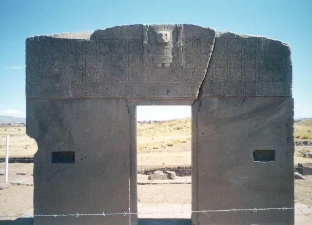
The Gateway of the Sun.
Among the structures that remain, the largest is the Akapana, a pyramid 56 feet high and 656 feet wide. It looks like the culture experienced a reformation of sorts; around 700, all previously built monuments in Tiahuanaco were torn down, and the stones in them were reused to build the Akapana. However, the Akapana was never completed, for the builders overestimated their ability to finish what they started. All of the monuments were built out of red sandstone and green andesite; some of the stones weighed as much as 131 tons and had been dragged by work brigades from quarries six miles away. Each block was shaped to a smooth, precise finish, and many had been set into place without mortar, a forerunner to Inca masonry. Some of the stones were clamped together with bronze or copper fittings--a sensible precaution in a land of frequent earthquakes.
Construction stopped altogether after 950. Rainfall around Lake Titicaca dropped considerably in the second half of the tenth century; call it either a prolonged drought or a change to a drier climate. The terraces and suka kollus farms allowed Tiahuanaco to feed itself longer than other Altiplano communities, but even careful land management could not compensate against bad weather forever. Around 1000, the capital was abandoned. The empire's second most important city, Lukurmata, declined once Tiahuanaco was gone, and by 1200 it was deserted, too. Thus, when the Inca king Pachacuti began conquering Lake Titicaca's basin in 1445, there was no organized state to resist him.
![]()
The Huari Empire
The Huari (also spelled Wari) were the other people, besides those of Tiahuanaco, that dominated Peru in Middle Horizon times. They established their kingdom in the central Andes around 500 A.D., starting with a city that is also called Huari, just a few miles from modern Ayacucho. Other important Huari sites are the “Northern Wari Ruins,” near the city of Chiclayo, and Pikillaqta (“Flea Town”), seventeen miles southeast of Cuzco.
From the cities of Huari and Pikillaqta, they expanded west, northwest and south. First they established colonies of settlers and traders, which paved the way for the conquest of outlying areas later. They conquered Pachacamac and the Lima culture around 650, but after that left the oracle alone. Sometime after 700 the Huari conquered the northern coastal lands of the Moche, Muchik and Sican; by 750 they had also conquered the Nazca.(53) In so doing they created South America's first military empire. However, we now believe that the bureaucracy in Huari City and Pikillaqta only ruled their former colonies indirectly, when it came to non-military matters, meaning it was more of a federal empire than a unitary one. The only place where Huari expansion did not meet with success was in the southeast, where their border met the border of Tiahuanaco's realm. There was sporadic fighting over a mine occupied by Tiahuanaco, but the Huari failed to take it for themselves. Even so, the Huari had the largest state South America had seen to this point, ruling all of the mountains and coast of present-day Peru, except in the south.(54)
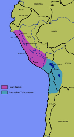
Map of the Huari and Tiahuanaco states.
We mentioned in the previous section that we know the Huari became followers of Tiahuanaco's Staff-Bearing God, because this deity began appearing with increasing frequency on Huari textiles and ceramics. But while they created a unified Huari-Tiahuanaco creed, replacing the religious diversity that had been the norm previously, the two civilizations remained different in politics, art and architecture. The Huari were more aggressive in planting colonies, for instance, but the exact relationship between the colonies and the city of Huari is not clear.
Huari City was even larger than Tiahuanaco, covering 1,200 acres and housing between 35,000 and 70,000 people, making it the largest urban center in the New World outside of Mesoamerica. Like Tiahuanaco, Huari attracted worshippers; the main neighborhood was a ceremonial quarter with temples, tombs and palaces for the upper class. Another quarter contained walled compounds where commoners lived. Artisans occupied a third quarter, where they turned out multicolored tapestries and ceramics, and copper and gold jewelry stone figurines inlaid with precious metals and colored shells. The city's houses were supplied by an underground water system.
The biggest difference between the Huari and Tiahuanaco was in their building techniques. The Huari used mud mortar between the stones of their houses and temples, and smoothed over everything with coats of clay and plaster. Apparently the Huari did not have Tiahuanaco's stonecutting skill; only in a few royal tombs did they try to duplicate it. They also built administrative centers in the provinces with a distinctly different architectural style from their other cities. Outside of the cities, the Huari did extensive terracing of the land and created a major road network, two essential tools for administration of the Inca Empire later on.
The Huari Empire lasted for more than 200 years, meaning that it outlived the better documented Inca Empire. Then in the ninth century, for reasons unknown, it unraveled fairly quickly. Perhaps the empire became overextended, like the Roman Empire after the first century A.D. or the United States in our own time. Social unrest, crop failures, and a breakdown of the trade network all could have contributed to the fall.
The most interesting clues to the Huari downfall came from Cerro Baul, one of their religious centers. Here US archaeologists discovered a massive brewery, that could produce as much as a thousand liters of chicha beer a day. This wasn't the pre-Columbian equivalent of Anheuser-Busch; the beverages produced were for ritual drinking, not popular consumption. The brewery was destroyed the last time it was used, leading us to believe that the Huari nobility realized their civilization was about to end, and instead of fighting it, they chose to go out with a huge party. They did their drinking around a bonfire, and then finished by burning down the brewery and throwing their ceramic cups into the fire, as if they didn't want any future civilization to make beer with help from them. What a send-off!
The city of Huari was abandoned around 900, and Chan Chan, the capital of the Chimu state, was founded at the same time on the northern coast, showing us that the Huari did not try to rebuild their state in the north. Likewise, at Pachacamac the local artisans blended Moche-Sican and Huari styles to create what would soon be called the Chimu style of art. To the south, Tiahuanaco was also past its peak, so while it lasted a century longer, it did not take advantage of any opportunities created by the Huari expiration. Still, these two nations had produced the concept and institutions of an imperial state; these would serve the Andean empires after them. And because Cuzco, the future Inca capital, is in the same part of the Andes as Huari City, it's a safe bet that the Incas got most of their culture from the Huari, and were descended from them as well.
This is the end of Part II. Click here to go to Part III.
FOOTNOTES
31. The looters did provide one useful bit of information. In the course of dismantling the huaca, they revealed that it was repaired, remodeled and enlarged several times during the early Moche period; no less than eight different levels of construction have been identified in the structure. Many bricks had symbols like an “X,” circle, or trident etched into them, or simply a finger or hand print, marks to keep track of which crew of workers made each brick. See Chapter 2, footnote #10 of my African history for an example of the Egyptians doing the same kind of inventory on their pyramids.
32. Some bird-shaped pots were cleverly constructed to whistle as liquids were poured out the spout; the sound came from air rushing in through another hole. On the other hand, Moche artisans were not as realistic with colors as they were with shapes. Most of their works used just four colors: yellow, red, white, and black. The huacas were painted with the same color scheme.
33. This Warrior Priest is also called the Lord of Sip�n, and because his tomb was discovered intact, he is sometimes called the Tutankhamen of America. The other Warrior Priest lived about two hundred years earlier, and was probably an ancestor.
34. The Sican culture, a local culture that existed on the coast near the La Leche and Lambayeque Rivers between 750 and 1375, may have been descended from the Moche. Moche and Sican art styles are similar, anyway. The Muchick language, spoken by Indians on the north coast of Peru, is also probably Moche in origin. And if you thought the Moche sacrifices were horrifying, check out this 2010 news story about Muchik sacrifices.
35. Because the Nazca lived in a desert climate, obviously they were concerned about the water supply. Besides conducting rituals to make sure they always had enough water, they dug underground tunnels called puquios, very much like the qanats in Iran, to carry water from the mountains to their irrigation canals. Though the puquios were constructed during the middle Nazca period, they were well enough maintained that some are still used by today's farmers.
36. Two Americans, Bill Spohrer and Jim Woodman, believed that the Nazca only would have made the lines if they had a way to see them from the air. In 1975, to prove this wasn't a crackpot theory, they built a hot-air balloon out of local materials, calling it the Condor I, and Woodman, with the help of a professional balloonist, Julian Nott, successfully flew it. The flight did not prove that anyone knew the principle of aerostatics (lighter-than-air aircraft) before the Montgolfier brothers launched their famous balloon in 1783, but it showed that any ancient culture with both fire and the loom could have made a balloon, had they wanted to.
37. A common planetarium program would not be enough to prove or disprove whether the Nazca lines are aligned with objects in the sky. We know that stars and constellations are not frozen in time; they gradually change their positions, using processes called precession and proper motion. Unfortunately I could not find out if the tests matching stars with lines took both precession and proper motion into account.
38. All Maya cities, even Tikal, were strictly ceremonial centers; only the upper class of nobles and priests lived within the city limits. Workers who served the city lived in nearby suburbs, while farmers lived on their farms. Both workers and farmers had pole-and-thatch houses with floors of plaster or dirt. The main reason why the cities were small is because they were all built in the jungle. Sure, wild plants and animals may grow out of control in a jungle environment, and there is never a problem with droughts (that's why we call them “rainforests”), but because poor soil is the norm, as we saw at the beginning of this chapter, you need much more land than is required in temperate climates, to feed the same number of people. Thus, the Maya never had a true “urban” culture like we see in other civilizations. We estimate that during the Classic era, the Maya-populated zone had at most 30 people per square mile, which makes their buildings even more impressive because they were not built by an army of slaves doing drudge labor. And with small cities, only a few people are going to have enough education to perform the research in astronomy and mathematics that the Maya are famous for.
39. Picture writing can be confusing to us; that's why the meanings of some Mayan glyphs are still not clear . Like today's Chinese and the ancient Sumerians, sometimes the Maya had each symbol stand for a separate word, while at other times they used synonyms or homonyms to make each symbol represent a sound. For example, a picture of a bat could mean “bat,” zotz in the Mayan language, or it could mean tz'ib, “to write,” because both words have a “z” sound; it was up to the scribes to decide which meaning was intended. Sometimes the wordplay got really fancy, as when they wrote the name of Smoke Jaguar, a king of Copán, in twenty different ways for one inscription.
40. The best primary source we have on the Maya is a book named Yucatan Before and After the Conquest. Ironically, it was written in the sixteenth century by Diego da Landa, the bishop who burned most of the Maya books.
41. So far, 90 percent of the Dresden Codex has been translated. A German mathematician, Joachim Rittsteig, claims that the book tells how an earthquake in 666 B.C. caused a city named Atlan to sink into Guatemala's Lake Izabel. Rittseig also asserts that the city's laws were inscribed on 2,156 gold tablets, and at the time this chapter is being written (March 2011), he has an expedition diving into Lake Izabel to recover the tablets.
42. Speaking of fakes, the most mysterious artifacts associated with pre-Columbian America are the crystal skulls that have been sold or donated to museums and private collections, since the 1860s. Because of the excellent workmanship used to make them, the skulls have definitely captured the public's imagination; you may have seen the Indiana Jones movie where Hollywood's most famous archaeologist goes on a quest for one. Usually they are described as Aztec artifacts, because of the known Aztec preoccupation with death and human sacrifice; sometimes they are also associated with the Maya, Toltecs or Mixtecs. However, crystal skulls are never mentioned in authentic ancient American literature or art. Moreover, no archaeologist has reported finding a crystal skull, nor is there any documentation to explain where the existing skulls came from. Thus, the simplest answer to the mystery is that the skulls are all fakes, which is why they only get a footnote in this work. They are more attractive than the skull of Piltdown Man, but just as misleading.
43. To give a lesson in how the Maya Long Count works, the date we call January 1, 1 A.D. would be written as the number 7.17.18.13.3. This is shorthand for 7 B'ak'tuns, 17 K'atuns, 18 Tuns (360-day years), 13 Uinals (20-day months), and 3 Kins (days) since the starting date in 3114 B.C.44. Tikal and Calakmul had special symbols, which we call emblem glyphs, to represent their cities in inscriptions. Calakmul's emblem glyph was a serpent, while Tikal's was a hair bundle (the Mayan word for both “kingdom” and “hair bundle” was mutal). Both glyphs were widely used outside those cities, so they became the emblems of the alliances, just as in our own time, the red star and the hammer-and-sickle became the emblems of communists everywhere.
45. The stone slab over Pacal's sarcophagus has a famous picture of Pacal in a reclining position, clutched by a monster, while the axis mundi, or World Tree, rises up behind him. The conventional interpretation of the picture is that it shows Pacal at the moment of his death, falling into the underworld. However, Erich von Daniken drew attention to this picture when he noted in Chariots of the Gods? that modern astronauts recline on couches while they wait for their rockets to blast off, and asserted this was a picture of a Maya astronaut. By doing this he ignored details that would never appear in a picture of a real astronaut, like the bird perched on top of the tree/capsule, and the fact that the “astronaut” is wearing shorts instead of a space suit.
46. Andrews IV, E. W., The development of Maya civilization after the abandonment of the southern cities. From Culbert, Patrick (ed.), The Classic Maya Collapse, Albuquerque, University of New Mexico Press, 1973, pp. 243–265.
47. “Greater Antilles” is a convenient name for the four largest islands in the Caribbean (Cuba, Hispaniola, Puerto Rico and Jamaica) and their nearest neighbors, the Isle of Pines, Grand Cayman and Virgin Islands. Today Hispaniola's name is rarely used; most people just think of the two nations the island is divided into, Haiti and the Dominican Republic.
48. When it came to platinum, the Indians of northern Ecuador were ahead of Europe. Platinum has a melting point of 3214.9o F., a temperature higher than what any European furnace could achieve before the eighteenth century. Therefore platinum was useless to them; e.g., if the Spaniards melted gold and found platinum in it, they separated the two metals and threw the platinum away. However, melting gold was precisely how the Indians found a way to work with platinum--they mixed platinum grains with gold dust and heated both over a charcoal fire. Unlike pure platinum, a platinum-gold alloy could be hammered and shaped into small objects.
49. Temperatures on the Altiplano are so extreme that you can say the region has four seasons every day: spring in the morning, summer at noon, fall in the evening, and winter at night.
50. Kolata, Alan L., The Tiwanaku: Portrait of an Andean Civilization. Wiley-Blackwell, Hoboken, NJ, 1993. ISBN 978-1557861832.
51. A few centuries after Tiahuanaco was abandoned, the Incas looked at the huge stones used in its buildings, and decided that gods or giants built the city.
52. The Staff-Bearing God may have been an early version of Viracocha, the creator god in Inca mythology.
53. Not everyone liked the new regime. At La Real, a site on Peru's southern coast, a cave containing more than one hundred Nazca-style mummy bundles was discovered in 1991. What is puzzling about this site is that the deceased were prepared for burial with all the usual care, but then every one of the bundles was ripped apart. The original seal was in place on the cave entrance when it was opened, and the mummies still had objects made of precious metals, so this does not look like the work of grave robbers; more likely the mummies were slashed by the same people who buried them. In 2011 Justin Jennings, one of the archaeologists involved in investigating La Real, proposed that this was an act of political opposition. In his scenario, the Nazca resented how their society had gone from being roughly egalitarian to a society where power and wealth were being concentrated in the hands of an alien elite, and because the Huari were too strong to oppose in life, the undertakers expressed their real feelings on them after they died. Jennings went on to compare this situation with the 2004 US presidential election, where many people supported the Democratic candidate, John Kerry, not because they liked him or his platform, but because they hated George W. Bush.
54. There is only one place in the jungle east of the Andes where evidence of Huari rule has been found. In 2011 archaeologists announced that the tomb of a Huari noble was discovered intact; he was buried with a silver mask and breastplate, two gold bracelets and two silver-plated walking sticks. The grave was in the Vilcabamba district, where the Incas had their last capital; you'll be hearing more about Vilcabamba in the next chapter of this work.
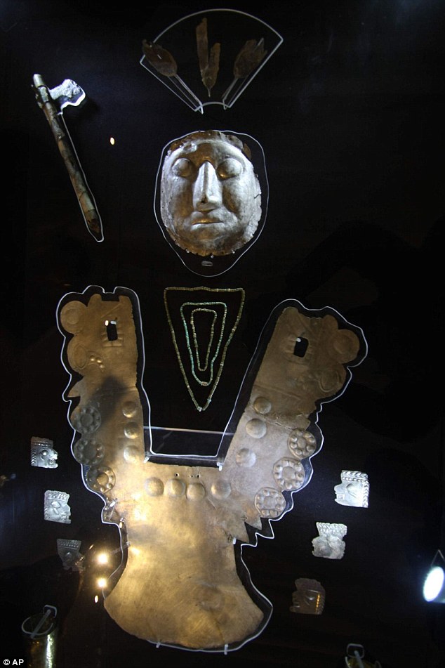
Support this site!
![]()
PAGE NAVIGATOR
A History of Latin America and the Caribbean
|
Other History Papers |
Beyond History
|