 | The Xenophile Historian |

 |
 |
 |
 |
 |
 |
 |
 |
 |
 |
 |
 |
 |
 |
A History of the South Pacific
Chapter 1: Of Lands and Seas, A Prehistoric Age of Exploration
Before 1500 A.D.
Pacific Geography
The Pacific Ocean is the largest physical feature on Earth, covering about one third of its surface and containing 46% of its water. The deepest point in the oceans is located here, in the Mariana Trench, and all along its rim are geologic faults, cracks in the earth, which have produced mountain ranges, volcanoes and earthquakes; that’s why the rim is also called the “ring of fire.”
We now believe that at one point in the distant past, the Pacific was much larger, because all the continents were on the other side of the world, merged into the super-continent of Pangaea. Thus, the Pacific covered more than half the world (the exact amount depended on how high sea levels were at the time), and with no major landmasses separating the Pacific from the Indian and Arctic Oceans, what the world really had was a single world ocean. The transformation of the world’s geography from Pangaea and the World Ocean, to the features we have today, is called continental drift; I have discussed it in Chapter 7 and Chapter 11 of The Genesis Chronicles.
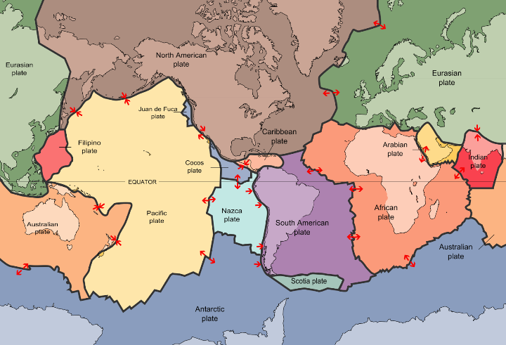
Continental drift is possible because the geologic faults divide the earth’s crust into more than a dozen plates. Whenever molten rock or magma rises up from the mantle, the easiest place for it to come out is through one of those cracks, or through a nearby volcano. We call it lava when it reaches the surface, and as it cools, it becomes new sheets of rock, pushing the older rock aside. If this process happens above water, it enlarges the land mass; it if happens underwater, it makes the ocean floor wider, so we call it sea-floor spreading. Either way, anything on top of the crustal plate, including islands and continents, is carried in one direction for a specified distance, like objects on a conveyor belt. Because the world is not getting larger, there also have to be places where the crust is shrinking, to offset the places where it is growing; that happens where two plates collide. In those places, the rock of one plate is forced under the other. The plate on top may be pushed upward to form a mountain range; whether or not that happens, the plate that goes back into the mantle melts into magma again. This recycling process is called subduction, and the world’s main subduction zones are the trenches in the western part of the Pacific, where the Pacific plate has run into the Eurasian plate, the Philippine Sea plate, and the Australian plate. Consequently the Pacific Ocean in the biggest loser in the sea-floor spreading game; it has been shrinking since Pangaea broke up.
The world’s biggest jigsaw puzzle.
Another feature of the Pacific Ocean tied to continental drift are the thousands of small islands that dot it; the Pacific has more islands than the other oceans put together. Many form as long chains along the aforementioned subduction zones, as lava oozes forth through holes in the plate that stays on top. Examples of these include the Aleutian and the Kurile Islands in the north Pacific, and the Mariana Islands near the trench by the same name.
It is also possible for an island to be created when a “hotspot” under a plate breaks through as a new volcano. If the plate moves in relation to the hotspot, the volcano will become extinct, and then another volcano – with another island – will form in the hotspot’s new location.(1) Then wind and water erosion will wear down the first island, causing it to get smaller over the years. The oldest and smallest islands are coral atolls; atolls are usually ring-shaped, with the land made up of coral as well as sand; only a fraction of an atoll’s land is useful to people.
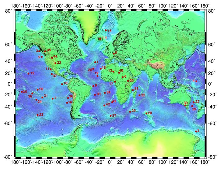
A world map showing the locations of forty-five hotspots, from the Azores (1), to the Anahim hotspot in British Columbia (45).
Source: Wikimedia Commons.
The best example of the moving hotspot process can be seen with the Hawaiian archipelago. Stretching 1,191 miles west of Kauai and Niihau, the westernmost inhabited islands in the state of Hawaii, is a long chain of small islands, called either the Leeward Islands or the Northwestern Hawaiian Islands. None of them have permanent residents, and most of the area was proclaimed a park preserve in 2006, the Papahānaumokuākea Marine National Monument. The islands farthest west, Midway and Kure, are coral atolls, home to just seabirds and former US Navy/Coast Guard bases. And that’s only what’s above water; a line of seamounts, underwater hills, run another 1,500 miles west of the atolls, until they meet the end of the Aleutians, near the Kamchatka peninsula. A long time ago those seamounts used to be islands, but erosion has washed away everything above sea level.
The Hawaiian hotspot created the islands that became those seamounts first, then as the plate above it moved to the northwest, it created the atolls, then the small Northwestern Hawaiian Islands, and finally the eight islands of present-day Hawaii; the latter are large enough to support permanent communities because they are the youngest, geologically speaking, and thus the least eroded. Currently the hotspot is under the southeast part of the island named Hawaii (often called the “Big Island” to distinguish it from the whole state of Hawaii). That hotspot is why the Big Island is big, and is what makes Kilauea the most active volcano on Earth; it has erupted every day since 1983.
Whenever glowing hot lava from Kilauea reaches the ocean, it shatters into smaller rocks, becoming the black sand that makes up Hawaiian beaches. The same ocean conceals the true size of the Hawaiian Islands, because they rise straight from the ocean floor, not from a continental shelf. With the Big Island, for instance, its highest point, Mauna Kea, is 13,796 feet above sea level, but it also stretches 19,680 feet underwater to reach the ocean floor. Put those numbers together and Mauna Kea is the real tallest mountain in the world at 33,476 feet, compared with 29,035 feet for Mt. Everest.
The latest and greatest continental movements began with the creation of the Mid-Atlantic Ridge, which split North and South America from Eurasia and Africa, thus giving birth to the Atlantic Ocean. As North America moved west and Eurasia moved east, they nearly isolated the part of the ocean around the north pole from both the Atlantic and Pacific; that became the Arctic Ocean. Likewise, when Australia broke away from Antarctica, it formed a sizeable (but not total) blockage to the waters between Antarctica and Southeast Asia, turning the Indian Ocean into a distinct body of water from the Pacific.
All the processes above are barely discernable today; continents and crustal plates move by less than an inch per year, so aside from those who live near an active volcano, only scientists measuring those movements are going to notice a change in their lifetimes. These processes probably moved faster in the past, though, so by the time the ice age ended, most of the world’s continents and islands were less than a mile from their present locations.
For the purposes of this narrative, we will not be telling the story of the entire Pacific Ocean. The northern boundary will be drawn at latitude 30̊ N. The only islands north of that line are the Bonin and Volcano Islands, which got all the attention they need in my work on Japan, and islands near the continents like Vancouver Island; of course it was no problem to include them when I wrote about the North American and Asian mainlands. Likewise, to the west we will leave out those islands that are considered part of Asia – Sakhalin, the Kuriles, Japan, Taiwan, the Philippines and Indonesia – since their histories have also been covered on other parts of this site. In the east we will not discuss the Galapagos because they already appear in The Genesis Chronicles and my Latin American history; like the Bonin and Volcano Islands, they had human visitors, but no one lived there before the nineteenth century.
That leaves Australia, Tasmania, New Zealand, New Guinea, and three major archipelagoes of smaller islands in the Pacific for our narrative. Often this whole region is called Oceania, so we will use that name occasionally. The three archipelagoes are called Melanesia (“the black islands”), Micronesia (“the tiny islands”), and Polynesia (“the many islands”); each is subdivided into smaller archipelagoes and island chains.(2) New Zealand, the Hawaiian Islands and Easter Island are all considered part of Polynesia, because the natives are ethnic Polynesians, though they are thousands of miles away from the rest of the archipelago. Indeed, those three sets of islands are sometimes called the points of the “Polynesian Triangle.”
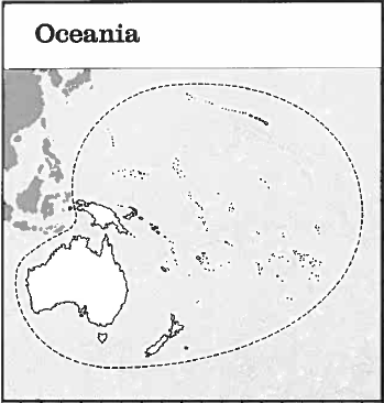
A very simple map of Oceania.
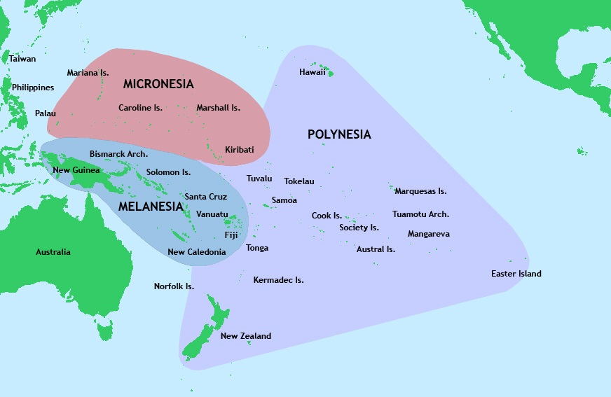
And here are the three great Pacific archipelagoes. Source: Wikimedia Commons.
Finally, after the narrative for the above places is done, this work will cover the story of the exploration of the Antarctic, because the South Pacific touches Antarctica, and the seventh continent has not received much attention anywhere else on this website.
One more thing needs to be mentioned before the narrative can begin: this chapter covers pre-history, not true history as you have read elsewhere. Nobody living in Oceania could read or write at this time; what’s more, they were not in contact with anybody who could read or write. The Indian and Arab merchants who came from the Indian Ocean continued to places like Indonesia and China, without stopping at the islands that concern us. Conversely, the Chinese ships that went forth simply traveled in the opposite direction, to the Indian Ocean.
Therefore we have no written records about the peoples of Oceania before the first European explorers arrived in the sixteenth century A.D. No doubt they had brave heroes and great explorers, as they migrated and settled all the islands in this region, but because their stories were not written down, they have been lost to us, except in some of their mythologies. If you limit yourself to written history, it began when Vasco Núñez de Balboa, a Spanish conquistador, discovered the Pacific. For this chapter we will have to go on what archaeologists and anthropologists working in this region have discovered; the best we can do is hope we date each path of migration/settlement to the correct century. And now let us go into the narrative . . .
![]()
From Sunda-Land to Sahul-Land
Because most of Oceania is in the tropics, it wasn’t frozen during the ice age like North America, Europe and Siberia, but the area was affected nonetheless. The freezing and melting of glaciers elsewhere did bring a chill even to equatorial lands; more importantly, it caused sea levels to fall and rise, thus changing the local geography. This created a number of land bridges that do not exist today, joining some islands together and joining other islands to the nearest continents. Two examples are of special interest to us: Sunda-land and Sahul-Land. Sunda-Land was the huge subcontinent created by the union of Malaysia, the Philippines and most of Indonesia with the Southeast Asian mainland. The same lowering of the seas made land bridges connecting New Guinea, Australia and Tasmania, turning them into a larger continent we call Sahul-Land.(3)
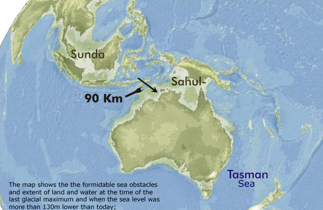
The land bridges that made Sunda-Land and Sahul-Land are shown here in light green.
Although Australia was never home to mammoths or saber-toothed tigers, it had its share of oversized animals during the ice age, or as paleontologists liked to call them, megafauna. These included seven-foot-tall kangaroos, wombats the size of rhinos, lizards as big as crocodiles, a marsupial lion, and the largest bird that ever lived, which has been nicknamed the "demon-duck of doom." At some point after humanity arrived and the ice age ended, all of these giant-economy-size creatures became extinct. Today there is an ongoing debate, with no end in sight, over whether this mass extinction was caused by the changing climate, or by hunters killing them all off (see also footnote #12).
The original settlers of Sunda-Land, and later Sahul-Land, were a people we call the Australoid race. Today they are chiefly represented by the Australian Aborigines; other Australoids include the Veddoid ethnic groups of south India and south Arabia, the Negritos of Southeast Asia, and the Andaman Islanders. They are distinguished by black skin, broad noses and large brow ridges. Since the nineteenth century Australoids have been classified as a separate race, though it has been suggested that they are related to black Africans. While this may be true, let us also keep in mind that Southeast Asia and Australia, like Africa, are hot places on or near the equator, so natural selection will tend to choose the same physical features. Dark skin, for example, is produced when individuals have large amounts of a pigment called melanin; melanin protects the skin from ultraviolet radiation damage, and when you live in a place where the sun is high in the sky on most days, melanin is definitely something worth having.
Those land bridges mentioned above made it comparatively easy for stone age man to travel around and settle much of the region; he didn’t need a boat where feet would do. However, in eastern Indonesia some gaps between the islands were too wide for people and land animals to swim across, even when ocean levels were at their lowest. The widest gap, between Timor and Australia, was nearly sixty miles; biologically speaking, the most important gaps separated Borneo from Sulawesi, and Bali from Lombok. Alfred Russel Wallace, a nineteenth century naturalist, noticed that the ecologies on the east and west sides of those two gaps were completely different; sometimes modern maps draw a line to mark the gaps, calling it the Wallace Line. Mammals on the east side are mostly egg-laying monotremes (the platypus and the echidna), and marsupials, who carry their babies in pockets; either way, their young need special protection because they are poorly developed when born. Monotremes and marsupials exist in this region because they got here first, before any placental mammals arrived. Placentals dominate the west side of the gaps; overall they are more efficient and more diverse, filling ecological niches the marsupials have left untouched, from elephants to primates. When marsupials and placentals are introduced to the same place, the marsupials usually cannot compete (the only marsupial I know of that has survived elsewhere is the opossum). Therefore, we will see it is a losing proposition for marsupials when placentals come to Australia, whether we are talking about rabbits, dingoes or human beings.
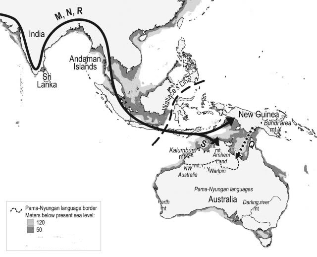
This map shows the Wallace Line, and the arrow is a proposed migration route that the Australoids and Melanesians could have taken.
Because of the gaps between the islands, early man would have needed some kind of water craft to make the crossing to Australia, and all evidence suggests that the Aborigines have been in Australia for an awfully long time, since the ice age at least. In modern times the Aborigines have not shown any skill at building or sailing boats, but evidently their ancestors did. Not only is their presence a clue, but some ancient petroglyphs (rock paintings or carvings) have been found in Australia, showing stick figures riding in canoes. If the stick figures aren’t pictures the Aborigines made of themselves, they must have known someone who could travel by water. Still, because the technology available at the time was stone age, simple canoes, only safe to use on calm seas, were the best transportation they had. Everything else they had was just as basic: spears but no bows or arrows, baskets but no pottery, and most important in the long run, no domestic animals or plants that could be cultivated. After they arrived they could not find plants and animals to replace what they had left behind: no native grains, few edible plants of any other kind, no animals useful for anything besides food, and an assortment of deadly creatures (crocodiles, snakes and spiders, to start with) that give Australia a reputation for being a dangerous place even today. Therefore the Aborigines could never make the transition from hunter/gatherers to farmers, and were stuck in the stone age until Great Britain colonized Australia. No wonder William Dampier, the first Englishman to meet the Aborigines (see the next chapter), described them as “the most miserable people in the world.”
After the Aborigines arrived, they spread across the continent, finding only the climate and wild animals opposing their progress. Like the Indians settling North and South America, they split into an estimated five hundred tribes, and contact between the tribes was irregular at best, so each tribe developed its own language over the centuries. Meanwhile the ice age ended, the glaciers started to melt, and sea levels rose, breaking up Sahul-land. Now the straits between the islands widened to the point that the canoes of the Aborigines could no longer make the crossing. If the Melanesians (see the next section) were on New Guinea by this time, they had boats seaworthy enough to keep on sailing(4), but for the Aborigines, their isolation was total.
In the next chapter, we will see that Australia was officially discovered by Europe in 1605 A.D. However, we now believe that previously, there could have been some accidental visits by outsiders like the Malays and Arabs, as they were sailing to other destinations.(5) The most recent unintentional visitors were probably the Chinese; in the early fifteenth century China sent vast naval expeditions to Southeast Asia and the Indian Ocean, and it appears that some of their ships got separated from the main fleet and landed on Australia’s coast in 1432 A.D. In all of these cases, no ship captain seems to have believed he discovered anything more than another island. And aside from acquiring dogs as pets (see footnote #12), the Aborigines were not affected by these visits – if they met the visitors at all. Because the isolation of the Aborigines continued, we will not have to talk about them again in this chapter.
 |
 |
The Melanesians
Three basic ethnic groups colonized the South Pacific: the Australoids, the Melanesians, and the Austronesians. We met the Australoids in the previous section, so now it is time to meet the other two groups.
The Melanesians (sometimes called the Indo-Pacific peoples) live in an arc of islands between the equator and the Tropic of Capricorn that includes easternmost Indonesia (places like Halmahera and Timor), New Guinea, the Solomon Islands, Vanuatu, Fiji and New Caledonia. They are dark-skinned, varying in color from tan to black, depending on the tribe. Their most unusual feature is that many Melanesian children, especially on the Solomon Islands, have blond hair, which darkens when they grow up. This has been traced to a different gene from the one that causes blond hair in people of European ancestry. Since blond hair also appears in some Aborigine children, it is tempting to suggest that Melanesians and Australoids are related. Most likely they had a single tribe as a common ancestor, which migrated from Asia, and they split into two groups on the way, one going to Australia, the other to New Guinea. Along that line, a big surprise came when the DNA of Denisova Man, a Siberian cave man, was examined in 2010, and 4 to 6 percent of the genome was the same as that of modern Melanesians, meaning that they are the closest living relatives to the Denisovans. Does this mean that ancestors of the Melanesians came from the heart of Siberia?
By far the most important island in the Melanesian zone is New Guinea; as the world’s second largest island (only Greenland is bigger), it has more land than any other place in Oceania besides Australia, and consequently is home to the most people as well. Therefore you can think of New Guinea as a home island or base camp for the Melanesians, from which they went forth to settle other islands. Before Europeans discovered New Guinea, it was known as Papua, so you may see New Guinea residents referred to as Papuans. However, we don’t know where the name Papua came from. One theory claims it came from the ruler of an Indonesian island, the sultan of Tidore; supposedly he described New Guinea as a land without a kingdom by combining the words papo (to unite) and ua (negation), to get “ not united.” A simpler theory asserts that Papua is a Malay word meaning “frizzy-haired,” referring to the afro hairstyle of the natives.
The first Europeans to meet the Melanesians considered them wretched, because of their primitive lifestyle. But compared with the Aborigines, the Melanesians were better off; whereas the Aborigines appear to have always been at a Paleolithic (old stone age) level before European contact, the Melanesians were at a Neolithic (new stone age) level. This means the Melanesians did some farming, instead of simply gathering whatever edible plants they could find. On the continents, farmers usually got the biggest yields from irrigated fields of grain, but on New Guinea, the crop most often grown was a root vegetable, taro (also called dasheen or elephant ears). Taro was never grown on a large scale -- the plots are garden-sized from our point of view. This was because the men continued to hunt (they did not have any domesticated animals to raise), and instead of staying in one spot, a tribe might pull up its stakes and move, in search of better hunting and farming grounds. As a result, a taro-based economy could feed 10-100 people per square mile, compared with more than a hundred people per square mile fed by farms growing millet, wheat, rice or other grains. Still, taro allowed the Melanesian population to grow large enough to keep most of the island for themselves, when others came to New Guinea.(6)
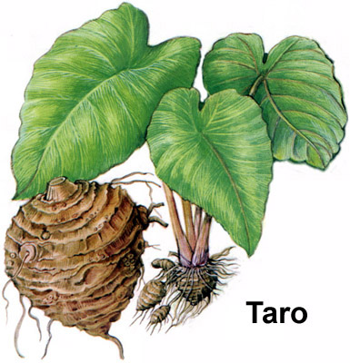
A taro plant. Source: Purdue University.
The most important thing to remember about the Melanesians is their incredible diversity. Just as no individual person can be seen as a typical example of the whole human race, so no Melanesian tribe can be called typical of the rest. We mentioned already that their skin color can vary; in addition, tribal structure can vary from near-anarchy to chiefs who enjoy hereditary rule. It is easy to understand what causes this diversity. Melanesians are physically isolated in small communities; they either live on small islands, or if they are on New Guinea, the jungles and mountains running across that island make transportation very difficult. So unlike the Polynesians, most Melanesians do not venture more than a few miles from home, either by land or sea, and communication between Melanesian communities is irregular.
Because of their diversity, we can only apply a few generalizations to the Melanesians. One has to do with the many species of plants and animals that live on their islands; thanks to the tropical (hot and wet) climate, they come in tremendous variety, like the people. Unfortunately, this also means the Melanesians are plagued by many pests, parasites and diseases (e.g., malaria), making life on these islands short and hard.
Languages are another example of how diverse the Melanesians can be. We estimate that a few centuries ago, the human race spoke approximately 6,000 languages, and 2,000 of them came from Melanesia.(7) One curious fact about Melanesian languages is that more than half of them did not get started with the Melanesians. While about 800 of their 2,000 languages have been traced to New Guinea, and are thus called “Papuan languages,” most of the rest are Austronesian in origin. Evidently when the ancestors of the Polynesians came to Melanesia, many Melanesians learned their languages and forgot their own; gradual changes in grammar and vocabulary over the centuries (call it “language evolution” if you wish) explains the rest.(8)
Melanesian communities and their tendency to stay at home made them strongly xenophobic. Strangers were not to be trusted, and the legs of trade routes were short because traders were not willing to go great distances with their goods. Melanesians also believed in and feared sorcery. All this meant that it was easy to start a quarrel between two villages, but warfare was usually limited to raiding and an occasional battle; conflicts were caused by real and imagined grievances, not by greed or a lust for conquest. On the other hand, because the inhabitants of a village are usually related to one another, many groups require that their members marry people from other villages, to prevent inbreeding; Melanesian marriages also usually require the payment of a "bride price" to the bride's father by the prospective son-in-law.
Melanesian economics and social structures are simple, compared with those of outsiders. In the typical tribe or village, aside from the chief, there is not a great difference in wealth or political power between individuals. Wealth is usually measured by the amount of food someone possesses at any given time, and since food cannot be hoarded or stored indefinitely, one’s “net worth” will go up or down depending on whether his food baskets are full. Sometimes an individual can use hard work, marriages with the right families, and/or patronage to produce enough food for a feast, or raise buildings that the whole community can use. Anthropologists call such a person a “Big Man,” and he enjoys considerable influence without power, for he only remains “big” as long as he can successfully compete with other ambitious folks trying to do the same thing. Once a “Big Man” retires, dies, or is outdone by somebody else, his authority vanishes; the “Big Man” status cannot be inherited or passed down to a relative.
Before European contact, the Melanesians were animists; instead of believing in a pantheon full of gods with specific personalities, they believed spirits, demons and ghosts(9) were present everywhere, and most of them were unfriendly. Religious ceremonies and rituals were performed not to worship the spirits, but to control them, either to keep evil away or to bring success in an undertaking. Thus, their tribes did not have priests but they had sorcerers who claimed they could work magic; these folks were widely feared. And that wasn’t all; in keeping with the xenophobia mentioned previously, several New Guinea tribes practiced headhunting or even cannibalism.(10) Before the twentieth century, Europeans avoided Fiji for the same reason, calling them the “Cannibal Isles” to make sure everyone got the point. Today, however, most Melanesians are Christians; the conversion of the New Guinea tribes to Christianity can be considered the greatest success of twentieth-century missionaries (see footnote #8). On that note, let us move on to see how the Austronesians/Polynesians came to the islands where they currently live.
![]()
Early Austronesian Migrations
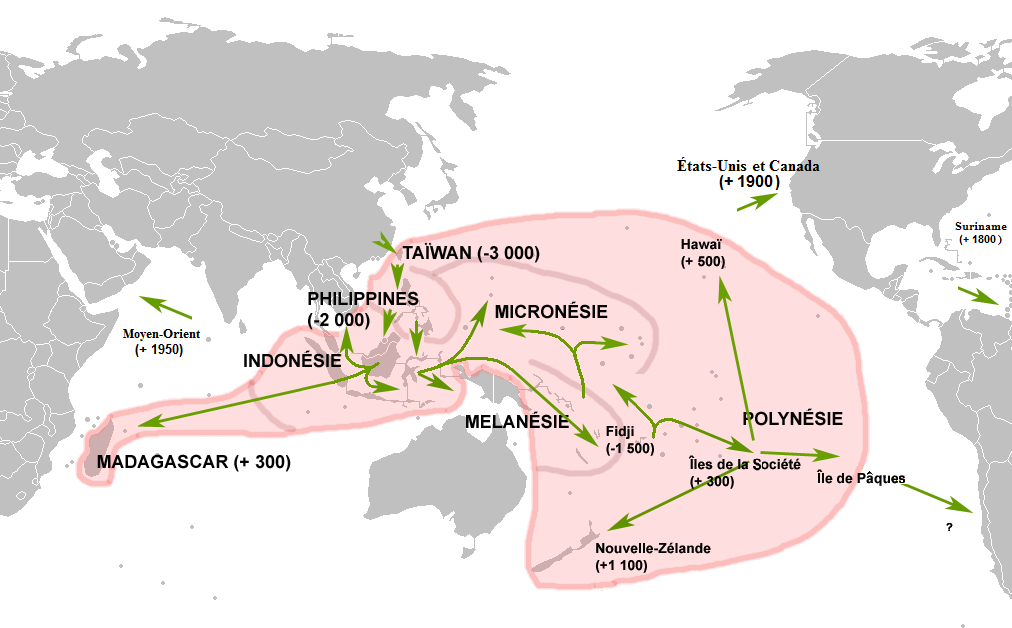
On this website, the Polynesians and their ancestors go by more than one name: Malayo-Polynesians, Malays, Austronesians, etc. Here I will call them “Polynesians” after they settle the islands of the central and eastern Pacific, and “Austronesians” either before that date, or when talking about their cousins in Southeast Asia and Madagascar. These are the people you are most likely to think of when somebody mentions the Pacific, because they traveled so far and wide; before Europeans learned how to cross the oceans, the Austronesian peoples were the world’s boldest and best sailors.
With their dark hair, slanted eyes and tan complexions, it’s a safe bet that the first Austronesians lived on the mainland of Asia. However, nobody can say which ethnic group in the Far East they are most closely related to, and when evidence of them appears, they are already living on the island of Taiwan. Likewise, we don’t know if they got to Taiwan by following an ice age land bridge that no longer exists, or by using the canoes that served as their first boats. With them they brought rice, for they were growing this grain before mainland neighbors like the Chinese discovered it. They also made pottery by this time; we can trace their footsteps from one island to the next by the pots they left behind. But don’t expect to see many Austronesians if you go to Taiwan today; waves of Chinese immigrants came from the mainland and overwhelmed the indigenous population, especially in the seventeenth and mid-twentieth centuries A.D. Thus, the Austronesian tribes, also called Formosans, only make up 1.5 percent of Taiwan’s present-day population, and are found mainly in the mountains and on the east coast, rather than in cities like Taipei.
At some point between 2500 and 2000 B.C., some Austronesians left Taiwan to go exploring. It probably did not seem like an important event at the time, because only a few people went on the journeys, while the vast majority of the Austronesian population stayed at home. Even so, with their canoes they managed to reach the Ryukyu Islands to the northeast, and the Philippines to the south; in both places they were able to proceed to more islands in a stepping-stone fashion. The group going to the Philippines was the most successful, for not only did rice plants thrive in those islands, but the Austronesians were able to settle the archipelago without any serious competition from other people.(11) Most important of all, they became expert sailors here, and learned that a canoe with one or two outriggers on the sides is stable enough to travel safely in the ocean, even when out of sight of the land.
In Chapter 1 of my Southeast Asian history I tell how the Austronesians settled the islands that make up the Philippines, Malaysia, Indonesia and Brunei, as well as some areas on the mainland (the Malay peninsula and central Vietnam). And that wasn’t all; from Southeast Asia the Austronesians would spread almost all the way across both the Indian and Pacific Oceans.(12) The part of this migration we are most interested in is the branch that went east; it started with an island hop from eastern Indonesia (Halmahera?) to the northern coast of New Guinea. As big as this island is, it could not have looked too promising, for the Papuans were already established here, and rice did not grow as well in the local jungles as the Melanesian staple, taro. The Austronesians would have faced an uphill struggle if they had tried to take all of New Guinea for themselves; in the end they only left a handful of new tribes in enclaves along the coast before moving on. Still, we know they traded with the Papuans because some Southeast Asian-style pots have been found on New Guinea; they also taught their language(s) and obtained taro and banana plants. Taro would become their new staple, because the islands to the east had few places fit for growing rice.
Between 1600 and 1500 B.C., the people living in the Bismarck Archipelago and the Solomon Islands began making a distinctive style of pottery. We call this Lapita ware, after an archaeological site on New Caledonia, and thus the sites containing it are identified with the “Lapita culture.” However, we don’t think Lapita ware was invented by the Melanesians living here already, but by Austronesians who ventured beyond New Guinea, only to find these islands taken. This was the eastern limit of what geographers sometimes call “Near Oceania.”
By 1200 B.C. Austronesians entered the next region, “Remote Oceania,” and they found islands that were uninhabited: Vanuatu, New Caledonia, Fiji and Tonga. They spread through this area quickly, in five to ten generations. A small group settled each island and introduced their favorite plants and animals: pigs, dogs, chickens, taro, yams, paper mulberry (the source of tapa cloth), breadfruit, bananas and coconuts.(13) We believe they explored mainly to satisfy their curiosity and their egos; each chief seemed to have wanted a whole island to call his own. Centuries later, there would be stories of expeditions going forth because of population pressure, exile, or wars, but the islands weren't yet crowded enough for these motivators to come into play. And while some islands could have been settled by boats drifting off course (e.g., Madagascar), the fact that they brought their crops and livestock along tells us that in most cases, the crews knew what they were doing. Along this line, we now believe Tonga was discovered and settled in 826 B.C., give or take eight years, and a group from Tonga reached Samoa just a few decades after that.
The area of the Lapita culture at its greatest extent. Source: Lapita-Voyage.org.
Today we regard the Lapita culture as the direct forerunner of both the Micronesian and Polynesian cultures. Around 500 B.C., we see the Lapita culture peter out, as the South Pacific islanders switched to other styles of pottery, or in some cases, stopped making pots altogether.(14) During the latter phase of the Lapita culture (1000-500 B.C.), a wave of Melanesian immigrants came to Vanuatu, New Caledonia, and Fiji; enough of them settled there to give the communities on those islands a Melanesian majority, though they continued to speak Austronesian languages. And while Tonga and Samoa remained predominantly Austronesian, some of them intermarried with Melanesians, giving their descendants a mixed ancestry. From this point onward we will call these people “Polynesian,” for the settlers of the rest of Polynesia came from here.
But the Polynesians could not go there now. The farther east they got, the greater the distances between the islands.(15) 350 kilometers (roughly 218 miles) was probably the maximum distance their outrigger canoes could travel on the open sea. The next leg of their migration would have to wait until they learned to build stronger boats with a greater cargo capacity.
![]()
The Polynesian Expeditions
At some point between 500 B.C. and 1 A.D., the Polynesians invented the watercraft they needed to keep going east. The solution was the catamaran, a double-hulled boat made by building a platform on top of two canoes, which held the canoes together and was strong enough to carry a load, including one or two masts with sails. Previously, boat-builders had to choose between speed and safety; a canoe can travel swiftly but is not stable, while a raft is wide enough to be stable, but travels slowly. Now with the catamaran, sailors could have both speed and stability. The largest catamarans had room for 250 people. These vessels could travel more than a hundred miles on a good day, and with them the Polynesians reached almost every bit of land in the South Pacific.
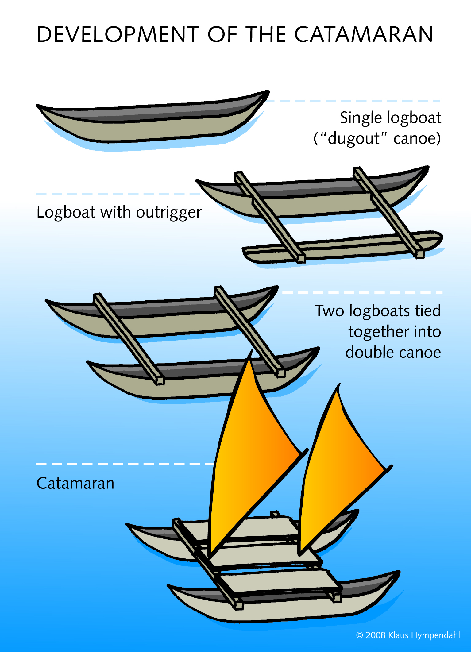
The evolution of Polynesian boats, from the dugout to the catamaran. Click on the thumbnail to see the picture full size (1.74 MB, opens in a separate window). Source: Lapita-Voyage.org
In addition, Polynesian navigators perfected their techniques for finding their way upon the sea. Instead of using any instruments, they relied on an assortment of tricks like following flying birds, and noting the directions of specific winds and waves. Even the shapes of a cloud could be a clue, because clouds assume a few specific shapes only when there is an island under them. Most impressively, they learned to follow specific stars whose distance north or south of the sky’s equator matched the latitude of their destination. For example, a boat sailing from Raiatea or Tahiti in the Society Islands would find Hawaii by taking a northbound course until the star Arcturus was overhead, and then go west until it reached Hawaii. To travel in the opposite direction, from Hawaii to Raiatea or Tahiti, a boat would sail south until the star Sirius was seen at the zenith of the sky, and then go east the rest of the way.(16) Many Polynesian legends tell of a community that chose to leave its island because of drought, war, or some other disaster; one person on the boat(s) picked a star in the sky to follow, and that successfully led them to an island that became a better home for them.
"Migraciones austronesias" by Maulucioni, based on previous work by Christophe Cag� - French Wikipedia/Wikipedia en fran�ais/Wikipedia en franc�s. Licensed under CC BY 3.0 via Wikimedia Commons.
Artifacts have been found in the Marquesas Islands, more than 2,000 miles east of Samoa, dating back to 100 A.D. This means that when the Polynesians resumed their exploration, they moved at least as fast as they did previously. To get this far they must have passed through three other archipelagoes – the Cooks, Societies, and northern Tuamotus – but we have not yet found artifacts on those islands older than 300-600 A.D. Therefore we do not know if they made the whole trip to the Marquesas in one leap, or if (more likely) they continued the practice of gradual exploration, hopping from one island to the next like a person on stepping stones. Today the Marquesas are isolated from the rest of French Polynesia, an unspoiled paradise dotted with ruins from an ancient population that was much larger than the population living there now, but nearly two thousand years ago it became an advance base for Polynesian expansion.
The eastern Pacific is virtually empty, and the Polynesians had to travel thousands of miles to find the remaining islands. Although their vessels and navigation techniques were better than ever, they couldn’t bring everything they needed; for voyages going more than a few hundred miles, they would have to get rainwater, fish, and favorable winds along the way, for a decent chance of survival. Because the chance of any voyage making a new discovery was low, they probably stopped sending migratory canoes carrying people, plants and animals into unexplored waters. More likely explorers went in those directions first, and when they returned home with news about what they had found, the vessels carrying migrating colonists went forth. Indeed, as we will see later in this chapter, the Maori have legends about New Zealand being settled this way, after it was discovered by an explorer named Kupe.
The most impressive achievement of the Marquesans was the discovery and settlement of Hawaii, around 500 A.D. To do this they would have needed to sail north-northwest for 2,200 miles, with no islands to stop at on the way. Nevertheless, we know they did it because ancient stone adzes and fishhooks found in Hawaii match those made in the Marquesas at the same time. They built their first heiau, or temple, on the Big Island, so that was probably the site of the first landfall; by 850 all of the major Hawaiian islands were probably colonized.
We used to believe Marquesans also discovered Easter Island, because Marquesas-style stone tools and fishhooks have turned up there as well, and a southeast-bound journey to that island would have been roughly the same distance as one to Hawaii. However, a comparison of Polynesian languages now suggests that Easter Island’s first inhabitants came from Mangareva in the Gambier Islands, or Raivavae in the Austral Islands (both are now part of French Polynesia).(17) It also was once thought the island was settled between 300 and 400 A.D., but carbon-14 analysis of the early campsites have yielded more recent dates, between 700 and 1100. Whoever did it and whenever it happened, it would have been an ambitious undertaking, for Easter Island is the most remote inhabited land in the world. The nearest land with anyone living on it is Pitcairn Island (1,289 miles away); the nearest point of land on a continent is in Chile, 2,182 miles away.(18)
The oral tradition of Easter Islanders gives the name Hotu Matu’a to the leader of the expedition that settled the island. He and his party came in two canoes (or one double-hulled catamaran) and landed at Anakena beach, the spot on the 64-square-mile island’s coast that provides the best shelter from the waves. From there the people spread across the island, which Hotu Matu’a divided between his sons; those sons and their descendants became the island chiefs, soon to be memorialized in the moai, Easter Island’s famous giant statues. However, it appears the island was politically united most of the time, because there was one culture, and each of the items needed for construction of the moai (stone for tools, stone for the statues, another kind of stone for the crowns on some statues, and food for the workers) came from different locations on the island, suggesting that one authority managed the statue project. We will come back to Easter Island later and see how those descendants fared.
The westernmost part of Polynesia, the Ellice Islands (modern Tuvalu) had been bypassed by the earlier, eastbound expeditions. Not that they missed much; with nine tiny islands (six of them true coral atolls) and a present-day population of 12,000 people, this is the fourth smallest nation in the modern world. Eventually Polynesians from Samoa, 765 miles to the southeast, came and settled here, possibly with some Tongans in tow. Estimated dates for their arrival range from 300 years ago to more than 2,000 years ago, with the most accepted arrival date between 1100 and 1300 A.D.
The last significant colony the Polynesians founded was on New Zealand. As with Easter Island, the date of the initial settlement has recently been moved closer to the present. A date of 925 A.D. was once proposed as the approximate date for when the ancestors of the Maori made landfall, because legends asserted that thirty generations have gone by, from the first arrivals to the present. However, that runs on the assumption that a generation lasts 30-40 years, and while that may work for the chronologies of certain Bible scholars, it ignores the fact that most people have their first child before the age of 25, making the length of a generation much shorter. Now radiocarbon analysis of rat bones and other artifacts from Maori sites points to a date of 1280 for landfall, or 24.5 years per generation.
Where the Maori came from is another good question; all they say about their ancestral land is that the name was “Hawaiki.” This word means “the distant home,” so any far-away place is possible, not necessarily a place with a similar name, like Hawaii. Most archaeologists lean to the Society Islands as the best candidate for where they came from, with a possible stop to found a colony in the Cook Islands on the way to New Zealand. To get there the settlers must have had a streak of luck, because the prevailing winds at New Zealand’s latitude blow from the west, meaning that most of the time a trip from other parts of Polynesia would have been sailing against the wind. More far-fetched theories have declared that the Maori were Egyptians, Greeks, Sanskrit-speaking Indians, or one of the lost tribes of Israel. One theory even gives different origins for Maori men and women, suggesting that the men were Papuans, while the women were Austronesians from Taiwan. We will come back to the story of the Maori on New Zealand later in this chapter, after we finish our introductions with the people who first explored and colonized the South Pacific.
![]()
Polynesian Cultures
It is easy to see that the Polynesians are related to one another, for their communities are as similar as the Melanesian communities are diverse. Not only do they tend to look alike, but their languages have similar vocabularies. This is especially true in eastern Polynesia; we will see in the next chapter that when Captain Cook went to New Zealand, he brought a Tahitian to serve as his interpreter, and this fellow learned the Maori language without too much fuss.
Another difference between Melanesians and Polynesians is that while Melanesian society is more or less egalitarian, Polynesian society is hierarchical. In fact, the more resources a Polynesian community has, the more social ranks exist, with a strong tendency to concentrate power in the hands of a few families. In the case of Hawaii and Tonga, the chief was an outright king, and while he commanded absolute authority over his subjects, his relatives usually chose his successor, who may or may not be a son of the current ruler. Female members of the ruling family also had considerable influence, though they usually worked through a brother, son or husband instead of trying to rule by themselves.
Today we often admire the Polynesians for living in island paradises like Tahiti and Hawaii; there the weather is usually pleasant, and the widespread distances between the islands mean that diseases, pesky insects, and dangerous animals are rare.(19) However, this did not mean the Polynesians were idle most of the time; they weren’t tourists, after all. The chiefs kept them busy growing food, and building canoes and houses; chiefs could also impress their subjects for a special project, like building a temple. On top of that, there were plenty of ceremonies everyone was expected to take part in, and the occasional war. Consequently most Polynesians did not live long – they wore themselves out first – and were considered old if they reached the age of forty.
Polynesian religion was like European paganism, in that it had many gods and each had his/her own department or portfolio; there was a god of the sea, a god of war, a god of farming, and so on. Likewise, when the Polynesians made offerings to their gods, it was not an act of adoration so much as an act of appeasement, to win divine favor and/or to keep divine wrath away. In addition, Polynesian religion was dominated by two key concepts, mana and tapu; Polynesian communities used priests and special experts to keep track of matters involving both.
Mana meant spiritual or psychic energy; everyone possessed it, and the more mana a god or person had, the more successful he or she could be. If a chief lost a war, failed to keep his people healthy and prosperous, or did not command much respect from his subjects, it was viewed as a sign that he did not possess enough mana, and thus could be replaced by someone who had more mana than he did. This was all the Polynesians needed to know to understand how the universe worked.
Tapu (also spelled tabu, or kapu in Hawaiian) has come into English as “taboo,” and was the series of prohibitions Polynesians observed, in place of a code of laws. For them the word did not mean forbidden but off-limits; a sacred object or place could be tapu as well. In some cases a person could be declared tapu to keep him protected or isolated. Probably the most extreme example of this was the king of Tonga; he was so tapu that if he entered a house it became tapu for anyone else to enter it, so he had to be careful about where he went. Punishment for violating a tapu was severe (often it was death), so before they met the Europeans, the typical Polynesian lived free of guilt so long as he did not break any tapus (after all, he might not be alive if he did!).
![]()
The Micronesians
East of the Philippines, north of Melanesia, and west of Polynesia are the chains of islands we call “Micronesia.” The geographical terms for the island chains are the Palau, Caroline, Gilbert, Mariana, and Marshall Islands. Today five nations exist here: the Federated States of Micronesia, Kiribati, Nauru, Palau, and the Republic of the Marshall Islands. Also, the United States currently rules the Marianas(20) and Wake Island. Because most of Micronesia’s islands are tiny, as we pointed out earlier, this region is resource-poor, compared with the archipelagoes surrounding it. There are also shortages of archaeological sites and artifacts, so historians have mainly used linguistic analysis to try tracing what happened in the region, before the Europeans arrived in the sixteenth century.
Micronesia was explored and colonized in two waves. The first wave happened between 2000 and 1500 B.C., even before the settling of Melanesia was complete. In this case, some Austronesians from Mindanao (the big southern island of the Philippines) took off in their outrigger canoes, and instead of going south to Indonesia like their cousins, they headed east and discovered Palau. The next stop was Yap, one of the larger islands in the Caroline island chain, and finally they reached the Mariana Islands. That is why the Chamorros, the indigenous ethnic group of the Marianas, look a lot like Filipinos.
The second wave did not advance quite as fast, taking from 1200 B.C. to 500 A.D. to explore and colonize the rest of Micronesia. Apparently a group from the southern Solomon Islands started it, sailing northward until they discovered the atolls that make up the Gilbert, Marshall and eastern Caroline Islands. Since land fit to live on is hard to come by in this region, they settled habitable islands whenever they found them. The last area occupied was the central Caroline Islands, (Chuuk Province in the Federated States of Micronesia) because there are quite a few atolls here, but almost no regular, sandy islands.(21)
After reading the history stated above, you probably see the Micronesians and their culture as an offshoot of Southeast Asia. In practice, however, the Micronesians more resembled the Polynesians, though at the same time their customs varied more from one community to another than Polynesian customs did. One common feature was a social ranking system so complicated that no two individuals would have the exact same rank; everybody seemed to be more important – and less important – than somebody else. Some communities used a person’s descent from his mother’s family to determine where he stood, in matters of inheritance as well as one’s place in the pecking order; other communities used descent from the father’s family or even from both families. The following table provides a simple way to keep track of the basic differences between the cultures of the three South Pacific regions:
| Category | Micronesia | Polynesia | Melanesia |
| Social Organization | Matrilineal emphasis Patriarchal (dualism) Club houses Two or three classes |
Ambilineal Patriarchal Usually three classes |
Patrilineal societies Fragmented social units Men's club houses Classless |
| Political Organization | Ramage Aristocratic ‘high island’ societies more hierarchical than atoll societies. Warrior ethics Decision by council Politico-military alliances between lineages |
Ramage Aristocratic ‘high island’ societies more hierarchical than atoll societies. Warrior ethics Chiefs autocratic Political units larger than lineages |
Egalitarian descent ’Big Man’ pattern Hereditary chiefs in some societies, but not usually markedly hierarchical. Warrior ethic Consensus’ rule Small units - village focus |
| Law | Arbitrary Supernatural and secular sanctions Application varied according to personal rank. |
Arbitrary Supernatural and secular sanctions Application varied according to personal rank. |
Arbitrary Stronger supernatural basis, with sorcery as means of punishment. More legalistic |
| Social Rituals | Kava drinking Feasting Competitive giving Elaborate display. |
Kava drinking Feasting Competitive giving Elaborate display. |
Betel nut chewing Feasting Competitive giving Elaborate display. Head hunting (some) |
| Religion | Tapu/mana complex Variety of spirits, gods and ancestors. Ritual was placatory, not worship. Use of magic Shamans, diviners, mediums and sorcerors. |
Tapu/mana complex Anthropomorphic sky-gods, ‘departmental’ (sea, forest, war, etc.) (Eastern Polynesia) Creator gods, ancestral spirits and household gods. Supplication and bargaining, not worship. Sacrifice (including human in many places). Priests, prophets and chief-priests After-life for chiefs only |
Tapu/mana complex Creator-regulator gods in places; ghosts and spirits capable of evil. Not worshiped but placated & manipulated by ritual. Magic and sorcery practiced extensively. Sorcerers but no specialized priesthood. Cargo cults (see Chapter 4). |
| Territory and Land Tenure | Territory occupied by a lineage(22) | Lineage definition of territory giving way to political definition. | Territory occupied by kinship group |
| Settlement | Extended | Usually extended; some hamlets | Nucleated, concentrated villages |
| Economy | Rich marine exploitation Swidden horticulture (often female role). Food preservation Craft specialists |
Rich marine exploitation Intensive horticulture (often male role). Food preservation Irrigation or other major works Craft and ritual specialists |
Limited marine exploitation Swidden horticulture (variously male and female) Not worshiped but placated & manipulated by ritual. Generally no food preservation Usually non-specialist |
| Trade, Navigation and Mobility | Atoll dwellers highly mobile Long voyages for trade, socializing and crisis relief |
Extensive communication within contact zones. Ancient long-range voyaging. Trade, social and political reasons. |
Some societies had a maritime capacity; trade was mostly with immediate neighbors. Mobility generally closely restricted |
| Values | Intensely competitive Hospitable |
‘Communal’ or competitive depending on scale of reference group (class, family, island) and the social or political context. Hospitable |
Strongly competitive, especially in Big Man system. ‘Communal’ elements on occasion. Xenophobic, suspicious |
Source: I. C. Campbell, A History of the Pacific Islands, Berkeley, Los Angeles, University of California Press, 1989, pp. 24-26.
![]()
The Tu’i Tongan “Empire”
One thing you are not going to see much of in this narrative are empires – at least until the Europeans and Americans take over. There are two reasons why you don’t hear of Pacific islanders who acted like Alexander the Great or Julius Caesar: a lack of motivation and a lack of resources.
- A lack of motivation: Several pages on this website discuss why civilizations developed in some parts of the world and not in others. In some places life is too difficult; if you live where it is too cold, too hot, or too dry, you’re going to be too busy struggling to stay alive, to think much about building cities and inventing things. Well, on the small islands of the South Pacific, you have the opposite problem; life there is too easy. Not only is the temperature ideal most of the time, but food is readily available; all you have to do is pick fruit from a tree or drop a fishing line into the sea. Because of the moderate temperatures, clothing is optional, and shelter is only needed to keep off the rain. People living under these “tropical paradise” conditions are not motivated to achieve much; after all, why would they feel the need to work harder to improve their lives, when they’ve got it made already? And whereas in other parts of the world, hunger can be a reason for one group of people to make war on another group, it’s not a factor in the South Pacific; a “let and let live” attitude comes easy, when everybody has enough to eat.
- A lack of resources: If you want to build an empire, you’re going to need an army, because not everybody is going to agree with your ambitions. That army will require soldiers, weapons, money, and plenty of other resources, all of which are in short supply when you live on a small island. The relatively low population means you probably won’t have the manpower to conquer other islands, to start with, and the shortage of land means you may have to do without vital minerals, especially metals. It’s no coincidence that the unification of Hawaii had to wait until the beginning of the nineteenth century, when muskets and cannon were introduced from the outside world.
Tonga probably had a number of early kings that have since been forgotten; things really took off with the establishment of a dynasty, the Tu’i Tonga, around 900. Between then and 1865, there were either thirty-nine or forty-eight kings who called themselves “Tu’i Tonga,” depending on which oral tradition you believe.(23) The first king of the line, ʻAhoʻeitu, reportedly was half-Samoan in ancestry, and began the task of uniting the 177 Tongan isles into a single state. He built his capital at the village of Toloa, on Tonga’s main island, Tongatapu. After him we don’t hear any more until the tenth king, Momo, took charge around 1100. Momo moved the capital to the eastern tip of the same island, at Heketā. At this point we begin to find Tongan artifacts on Fiji and Samoa, suggesting that Tonga enjoyed a strong influence there, if it did not rule Fiji and Samoa outright.
The next Tu’i Tonga, Tu’itatui, built the most impressive structure still standing from ancient Tonga: a trilithon (an arch made from three huge coral-limestone blocks, like the arches at Stonehenge) called the Ha'amonga 'a Maui. Each of the stones in the trilithon weighs between thirty and forty tons. One legend asserts that Tu’itatui built it as a monument to his sons, Lafa and Talaiha'apepe; the two lower stones represented the sons, while the lintel on top was a message that they should not quarrel after their father’s death. It appears that the sons did get along, but they also did something the old king probably would not have approved of; they moved the capital again, this time to Mu’a, just seven miles from the present-day capital of Tonga, Nuku’alofa. They reportedly made the move because Mu’a was on Tongatapu’s interior lagoon, making it an excellent place to keep the large catamarans used for transportation and communication between the islands Tonga ruled. Today the main attractions in Mu’a are artificial hills, each covered with two or three terraces of coral-stone; these are the Langi tombs of an estimated twenty-two ancient Tongan kings.
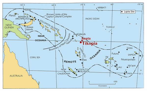
The fact that Tonga could afford to build the Langi tombs, and had the ability to do so, tells us the Tongan maritime empire was at its peak in the early thirteenth century. The extent of the area that Tonga ruled, directly or indirectly, is thought to have stretched from Niue in the east, to Tikopia in the Solomon Islands – an area 1,500 miles wide. Archaeologists have examined 200 stone tools from Tonga that date to this period, and 300 stone tools from other islands, and by analyzing the stone the tools are made from, they learned that as many as 66% of the Tongan tools were made elsewhere, including one adze from Tahiti, 1,550 miles away. Other tools have been traced to East 'Uvea, Rotuma, Futuna, Samoa, Niue, Kiribati, Pohnpei, Vanuatu, New Caledonia and the Loyalty Islands. By contrast, most of the tools found on the other islands were made locally. The most popular theory is that the tools were brought to Tonga as gifts or tribute. In later centuries, the Tu’i Tonga had the chiefs under them bring tribute every year at harvest time; this get-together was called the Inasi, and the gifts donated became offerings to the gods. However, it is also possible that the non-Tongan artifacts got to Tonga through a highly successful trading network, rather than a true physical empire.(24) But even those who prefer the idea of a trade network have admitted that "empire" is probably the most convenient term.(25)
Tongan power and influence began to decline around 1250, when Samoa staged a successful revolt. The Tu’i Tonga kings also seem to have lost their skill at ruling, for more than one were described as tyrants and subsequently assassinated. Two of them, Havea I and Havea II (the 19th and 22nd kings respectively) were killed by Fijians, while the 23rd king, Takalaua, was killed by two foreigners from either “Uvea (modern Wallis) or Futuna, while he was swimming in the lagoon of Mu’a. His son, Kauʻulufonua I, refused to be installed as the next king until he chased the assassins all the way to ‘Uvea, brought them back, and killed them.
Kauʻulufonua may have gotten his revenge, but he realized that something had to be done, or he could very well become the next victim. Accordingly, in 1470 made the Tu’i Tonga a less inviting target, by giving his day-to-day responsibilities to his brother, Moʻungāmotuʻ, leaving just the ceremonial duties for himself. In effect he made his brother a prime minister, and allowed his brother’s descendants to inherit the job, thereby establishing a second dynasty, called the Tu'i Ha'atakalaua.
From this point onward the Tu’i Tonga monarchs acted like high priests, rather than like real kings – and there were no more Tu’i Tonga murders. The next three Tu’i Tonga rulers lived on Samoa, because the Tu'i Ha'atakalaua rulers did not want them to regain their power. Because of that, and because they married Samoan women, the Tu’i Tonga became more Samoan than Tongan in a couple generations.
In 1610 the sixth Tu’i Ha'atakalaua, Mo'ungatonga, decided to share power with his half-Samoan son, Ngata, and created a new position for him, the Tu’i Kanokupolu. As time went on, however, the Tu’i Kanokupolu rulers took away the power of the Tu’i Ha'atakalaua, turning the latter into a second dynasty of figureheads. In fact, the present-day kings of Tonga come from the Tu’i Kanokupolu line. Because the Tu’i Kanokupolu did not do away with the Tu’i Ha'atakalaua and the Tu’i Tonga, all three dynasties coexisted until the end of the eighteenth century. You could say that for Tonga, one king was not enough.
![]()
Nan Madol
There does appear to have been one attempt to build a great nation in Micronesia. Pohnpei, the largest of the Caroline Islands, divides its pre-colonial history into three phases:
- Before 1100 A.D.: the Period of Building, or the Period of Peopling.
- 1100-1628: the Period of the Saudeleur, or the Lords of Deleur.
- 1628-1885: the Period of the Nahnmwarki.
During this period Pohnpei had an estimated population of 25,000, and the Saudeleurs put them to work building up Nan Madol into a capital city. Starting with a lagoon, they constructed ninety-two artificial islands, by piling up blocks of columnar basalt on top of a coral reef foundation. Columnar basalt is a lava rock that naturally forms in the shape of logs or rectangles when it cools, which can be shaped into blocks the same size with only a little effort, making it an excellent building material -- if you have the strength to move it. Between the islands they left a series of canals, making Nan Madol the “Venice of the Pacific.” Surrounding it all was a stone wall that reached as high as twenty feet. The whole complex covered about eleven square miles when finished, and was home to between 500 and 1,000 people – the entire nobility and their servants. Because no food or fresh water was available within the city limits, the rest of Pohnpei’s population had to bring it for the benefit of the ruling class. One part of the site served as a priestly and mortuary center, where important religious ceremonies were performed and tombs were built for dead nobles. The natives did not have draft animals to help them move the stones, nor did they have pulleys, levers, or metal tools; they could not even write down their plans for the building project. Therefore the way they accomplished Nan Madol's construction is an unsolved mystery.
A sample of the Nan Madol ruins, showing the amazing masonry that went into them. From Wikimedia Commons.
As the greatest building achievement in the Pacific, Nan Madol rivals the statues of Easter Island. Nevertheless, today’s Micronesians regard the Saudeleurs as oppressive rulers, because it took an extravagant amount of labor and taxes to maintain their city. On a per capita basis, the cost was even greater than the cost of pyramid-building in Egypt and the Americas; at least with pyramids, you don’t have to spend much to maintain them, once they are finished. Since the end of the Sardeleur dynasty came after the cut-off date for this chapter, we will save that story for a future chapter of this work.
![]()
Easter Island’s Mysteries--Solved
To modern man, one of the most exotic and mysterious places in the world is the Isla de Pascua, a territory of Chile known in English as Easter Island; the natives call it Rapa Nui. Since Thor Heyerdahl’s Kon-Tiki expedition (see footnote #17), much interest has been generated by the island’s intriguing giant stone statues. There are 887 moai, as these statues are called by the natives, and we believe they were raised to commemorate the island’s chiefs. A typical statue stands 13 feet high and weighs 13.8 tons; the largest completed statue was 33 feet tall and weighed 82 tons, and there is one unfinished statue that would have stood 69 feet high, and weighed 270 tons, if work on it hadn’t stopped. Nearly half of the statues stand near the quarry where they were carved, buried up to their shoulders; others were hauled to various spots on the island’s coast and set upright on stone platforms called ahu. Cremation pits have been found near some of the ahu, but we don’t know if the funerals conducted there had anything to do with the statues or the chiefs they represent.
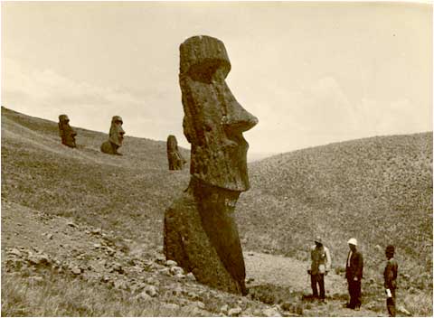
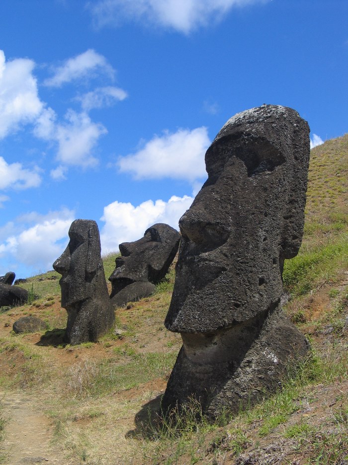
Two pictures of the moai.
People have speculated about the statues because today the resources (manpower, ropes, and wood) for carving and moving these colossi simply do not exist. One popular writer, Erich Von Daniken, declared with a straight face that the moai were erected with ultramodern technology by aliens marooned on the island; others have speculated that a highly advanced human civilization that left no traces of its existence (Lemuria, perhaps?), provided machine tools to do the job.
In recent years, scientists like Jared Diamond and David Steadman have thoroughly examined all the physical evidence they could find of Easter Island’s past life – the contents of garbage heaps, the identification of pollen grains from campsites, radiocarbon dating, and so on. The story they put together was a frightening one. Once upon a time the Easter Islanders had enough people and the means to erect the giant statues. The reason why they cannot do it today is because the Easter Island culture ate itself out of house and home.
When the Dutch explorer Jacob Roggeveen discovered the island in 1722 (see the next chapter), it looked like a wasteland. The plants were mostly grasses, sedges and ferns; no tree, bush or shrub was more than ten feet high. The only native animals were insects; there was no bird that didn’t fly in from the sea, no bat, no snails or lizards. What makes this so odd is that Easter Island has a climate that just about everyone would find pleasant. Located at latitude 27o south, it is the same distance from the equator as Sarasota, Florida, so most of the weather is subtropical, with a cool, wet, windy winter. And because the island was formed by volcanic activity, the soil is quite fertile.
However, it wasn’t always that way. We now know from pollen analysis that the island used to be covered with a dense forest. Three trees from that forest were especially useful to the settlers:
- The hauhau tree provided fibers for making rope.
- The toromiro tree made excellent firewood.
- A species of palm tree (Paschalococos disperta), related to the Chilean wine palm, that is now extinct. Back in the day, this palm dominated the forest, growing up to 82 feet high, with a six-foot wide trunk. The palm trunks could be made into canoe hulls, or rollers for transporting the statues. In addition. the palm had edible nuts, and its sap could be made into sugar, syrup, honey, and wine.
For variety, the Easter Islanders could catch birds. Previously the island’s remote location and lack of predators made it a great place for birds to live, but now they were either hunted to extinction, or if they could fly across the sea, they sought nesting places elsewhere and did not come back. A few seal bones suggest that the island once had a seal colony, like the monk seals of Hawaii; if they were around when humans arrived they would have been hunted, too. Finally, the settlers learned how to make a stew from the rats. For most of us, any dish with rat in it is gross, but the settlers must have enjoyed it; Easter Island is the only place in Polynesia where rat bones outnumber fish bones in the trash heaps.
The best years for the Easter Islanders were between 1200 and 1500; we estimate their population grew to seven thousand by this time, and it may have reached 20,000 before all was said and done. Most of the moai were carved and raised during this period. As time went on the builders and their patrons grew more ambitious; the moai and the ahu got larger, and some statues had fancy frills like eyes made of coral and obsidian, or red sandstone hats/crowns on top. Either the builders were looking for a bigger challenge, now that they knew they could make a plain statue, or the chiefs were now trying to outdo each other, using the statues to flaunt their wealth and power.
Unfortunately, while all this was going on, the community was also destroying its future. The pollen and seeds from archaeological sites dated after 1200 show a decrease in material from trees, and an increase in material from grasses. This tells us that deforestation was underway by 1200, if not sooner. The natives cut down the forest, one tree at a time; the process was probably so gradual that only the oldest people would have noticed what was happening. Most important of all, the palm trees felled were not replaced, because rats ate the palm nuts before they could sprout into new trees. Sometime in the fifteenth century the natives cut down the last palm without realizing it. The hauhau and toromiro trees did not become extinct, but their numbers dropped like a rock, until there were no longer enough of them to supply any more rope or firewood.(26) With the disappearance of the forest, most of the native animals and birds followed the trees into oblivion.
Alas, this time they could not supplement their deteriorating diet with seafood, because they no longer had tree trunks fit to carve into seagoing canoes. Around 1500, they stopped hunting dolphins for this reason. The only kinds of fish still available were those that could be caught with a fishing line cast from the shore. Gathering more shellfish worked for the short run, until they over-harvested the mollusks around the island. In desperation they raised more chickens, and began hunting a source of meat they wouldn’t have considered previously – humans. Human bones replaced dolphin bones in the trash heaps, and the islanders added stories of cannibalism to their oral tradition.
The collapse of Easter Island’s society came not long after the collapse of the ecosystem. Without the forest, rainfall decreased, springs and creeks dried up, wind and water erosion wore down the soil, and the harvests from crops shrank. Construction on the moai came to a halt, either because of a civil war or simply because the workers realized they did not have enough rope to move even the smallest statue. Instead, they began to carve the moai kavakava, small wooden statues of emaciated people that must have been modeled after real starving folks that they knew. Finally, the population fell; even today Easter Island’s population is far below what it must have been at its peak.(27)
The above story sounds like a real-life version of Dr. Seuss’ “The Lorax,” and you can probably see the moral to it: if you destroy/consume your resources without giving a thought to replacing them, someday your civilization will come crashing down. When the damage had been done, the Easter Islanders could not flee across the ocean to a new home, and if we ruin the only environment we’ve got, we cannot leave our planet either. So far we have not found a planet like earth, and the odds are stacked against us ever finding one.
The Easter Islanders had an excuse in that they did not keep track of what they were doing, and eventually forgot about it. Later in this work we will see they had a system of writing called Rongorongo, but this script was not used to record important events; it may not have even been invented before the eighteenth century. By contrast, our ability to store information can keep us from repeating their mistakes, so we can manage our oceans, forests, energy sources and farms in ways that will leave something for our descendants. And while our advanced technology can protect us from some of our mistakes, its complexity also means there are many more ways for it to go wrong. A power blackout won’t affect people whose homes do not have electricity, for instance, but in places like a modern-day hospital, electricity is essential for life itself. To quote my favorite line from the movie Star Trek III, “The more they outthink the plumbing the easier it is to stop up the drain.”
![]()
Aotearoa
The indigenous people of New Zealand, the Maori, believe their story began with a chieftain named Kupe, who ruled the island of Hawaiki. The stories about Kupe vary tremendously from one tribe to another; click on this link to read the Hawaiian version of the legend which matters to us.
In a nutshell, Kupe’s fishermen had a problem; for several days they went fishing, and while something was taking the bait off their hooks, they did not catch any fish. Eventually it was discovered that octopi were stealing the bait, and they were led by a giant octopus, which belonged to Muturangi, the high priest of the island. When Kupe when to complain, Muturangi said he couldn’t do anything about what his pet ate and where it went in the ocean.
At this point, Kupe considered killing Muturangi, and the fishermen tried to kill the octopi that went for their bait, but soon everyone realized that the simplest solution would be to just kill the giant octopus; then the other octopi would disperse. Accordingly, when the giant octopus escaped to sea, Kupe had his voyaging canoe prepared to chase it; with him he brought his family and some naysayers who had predicted he would not come back alive if he went on this journey. They followed the octopus all the way to Cook Strait, the narrow waterway between New Zealand’s two main islands, where Kupe fought and killed it. Then they explored the nearby land, found it both rich and uninhabited, and returned to Hawaiki with news of what they had discovered. Kupe told them they could get there by sailing to the left of where the sun sets in November. All versions of the story state that when the colonists made the journey, they traveled in seven waka (the Maori word for large canoes) with the following names: the Aotea, Te Arawa, Kurahaupō, Mātaatua, Tainui, Tākitimu, and Tokomaru. Nowadays a typical Maori will trace his ancestry to the generation that came in those canoes, and tell you which one his ancestors were in.
The Maori name for New Zealand is Aotearoa, the “Land of the Long White Cloud.” The author thinks this name refers to the Southern Alps, the range of snow-covered mountains on South Island; a people unfamiliar with ice and snow would naturally be reminded of clouds if they saw the stuff at a distance. They would have found both major islands covered with forest, and abundant bird life, including a dozen species of moa, weighing anywhere from 40 to 550 lbs., and the Haast’s eagle, the world’s largest eagle. Those who stayed on the coast would have had access to fish, shellfish, and seals as well.
That wildlife would have been necessary for survival, because the Maori could not have fed themselves on the foodstuffs they brought with them. This was especially true on South Island; North Island’s subtropical climate allowed them to grow the sweet potatoes, gourds and taro they had brought on their catamarans, but the South Island was too cold for any introduced plants to do well. And while they introduced Polynesian dogs and rats, we don’t see any evidence of pigs or chickens, both of which are much better food sources. Either there were no pigs and chickens on their boats, or they did not live long after arrival. Therefore the Maori made ends meet by hunting. In the case of the moa, this meant slaughter on a large scale. Bones from an estimated 29,000 to 90,000 moa have been found at the mouth of the Waitaki River, and bones from another 6,000 birds turned up at the mouth of the Shag River.
The moa was one of the largest birds that ever lived (the largest type of moa stood ten feet tall when it held its head up), and was not only flightless, but wingless. Before the Maori appeared on the scene, the moa’s only enemy was the Haast’s eagle. Flightless birds are usually found on islands because they are an easy target for predators, and have not learned to avoid animals that can be dangerous, so they need to be in places where predators can’t get at them. Indeed, another flightless bird, the kiwi, has become the symbol of New Zealand (New Zealanders even call themselves “Kiwis”).(28) When predators are introduced from elsewhere, or humans hunt them or modify the local environment, flightless birds quickly die; in an island ecosystem they are the literal “canaries in a coal mine.” It is no coincidence that another flightless bird, the dodo, is a symbol of extinction,(29) and we believe no less than twenty species of flightless birds became extinct in Hawaii within a few centuries of the Polynesian arrival there. On the continents, the African ostrich, the South American rhea and the Australian emu have survived because people find them useful enough to raise them.(30) No such luck for the moa, though. The last moa were killed off in the 1400s, and the Haast’s eagle became extinct around the same time, because it had lost its food source.
The Maori population must have grown rapidly during the archaic, moa-hunting phase; within a century they had spread all over both North and South Islands.(31) Also, we do not find many weapons or fortified settlements, which were common after 1500. Still, they did not have it easy. An examination of the skeletons found at one site, Wairau Bar, found that life was short; the oldest person there lived to be thirty-nine, and most died in their twenties. In addition, they suffered from dietary deficiencies, anemia, arthritis and tuberculosis.
The disappearance of the moa meant the Maori had to concentrate their attention on other food sources; including some poisonous plants that required several hours of preparation/cooking to make them edible. They also became more competitive over the shrinking food supply; that is probably why they became the most warlike of all Polynesians.
We now call the period from 1500 to 1642 (the year when Europeans discovered New Zealand) the “Classic” period, because the Maori warrior culture was fully developed by this time.(32) This was when they built fancy meeting houses, hilltop forts called Pa, their largest war canoes, and carved various ornaments out of pounamu (nephrite jade). Because their culture was both aggressive and highly developed, the Maori made sure they would always play a part in New Zealand society, even after the white man took over.(33) Around 1500 a group of Maori sailed 525 miles east of New Zealand and colonized the small Chatham Islands; they founded a culture of their own called the Moriori, which unlike the Maori culture was deliberately pacifist.
![]()
Epilogue
The Maori expedition to the Chatham Islands marks the end of the Austronesian/Polynesian age of exploration. The only other late expedition worth noting is one from Tahiti that went to the Hawaiian Islands around 1300, and conquered them. The original Marquesan population was enslaved and assimilated; that is why the present-day Hawaiian language is related to Tahitian. Hawaiian mythology talks of a race of dwarves called the Menehune, which the ancestors of today’s Hawaiians drove out of the islands; those could be the Marquesans under another name. Finally, the Tahitians gave Hawaii its name; they renamed the Big Island after one of their islands at home, presumably the same island the Maori called Hawaiki, and later the name spread to the whole archipelago.
Polynesian exploration stopped because they had run out of islands to discover, explore and settle. About the only islands they had not found in the South Pacific were the Galapagos, and going there would have been a challenge; to do so meant sailing east for at least two thousand miles, against a current flowing in the opposite direction, and because these islands are situated right on the equator, ships going to and from there would have been in the doldrums, the calm zone around the equator where winds are weak and unreliable. It is tempting to think the Polynesians reached the Americas at some point, but the only evidence of Polynesian contact that the author knows of comes from the Chumash tribe of southern California, which built Polynesian-style outrigger canoes. If the Polynesians had tried to occupy any territory on the mainland they would have been up against an opponent from a higher league, for the Native Americans would have outnumbered the intruders and had access to far greater resources.(34)
After 1300 it appears the Polynesian horizon contracted a bit; you could even say they were beginning to stagnate. For example, we have found artifacts on Nihoa and Necker Island, the nearest of the Northwestern Hawaiian Islands to Kauai, dating as far back as 1000 A.D. This tells us the Hawaiians at least visited those islands, either to fish or to perform religious ceremonies; however, they stopped visiting by 1500. In the waters northwest and northeast of New Zealand, Polynesians settled Norfolk Island and the Kermadec Islands in the fourteenth century, but those settlements disappeared in the fifteenth. It looks like the residents decided to abandon their settlements, when they realized those islands were poor or otherwise undesirable. The same thing happened with some less remote islands: Pitcairn and Henderson on the route between Tahiti and Easter Island, and Fanning and Christmas in the Line Islands (between Hawaii and Tahiti). This had the result of isolating the most distant communities, and by 1500, the islands on each apex of the Polynesian Triangle (Easter Island, Hawaii and New Zealand) had lost contact with the rest of Polynesia. With New Zealand, the Maori may have arrived on catamarans, and continued to build/use them until the 1400s, but afterwards they switched to their own distinctive canoe design, showing us they no longer went to sea regularly.(35)
The residents of the Pacific islands had proven themselves to be true peoples of the sea, but they may have reached the limits of what they could accomplish without metallurgy, writing, and the other elements of a fully developed civilization. What they didn’t know was that agents of a civilized culture, that of Europe, were on the way. The Europeans started exploring in the 1400s; because they had an awfully long way to go, being on the other side of the world, and because they knew nothing about the Pacific, it took them a century to blaze a trail to Oceania. They would not stop until they had gone to every part of the world that could be reached by wooden ships, leaving only the Arctic and the Antarctic to be explored in a future age. The peoples living in the South Pacific had set the stage and provided most of the players; now newcomers would begin to change the communities of the region almost beyond recognition.
This is the End of Chapter 1.
FOOTNOTES
1. When hotspots don’t create islands, they can support life. This phenomenon was discovered in 1977, when a submarine dived to explore the undersea volcanoes near the Galapagos Islands. As the sub passed hydrothermic vents, spots where hot water was coming out of the ocean floor, cameras took pictures that showed those areas teeming with life: clams, giant tube worms, fish, crabs, shrimp, and other animals, most of them from previously unknown species. These oases of life are too deep in the abyss to receive any sunlight, so how do they survive without plants? Well, the vents are also called black smokers because they spew forth clouds of chemicals like hydrogen sulfide. Microbes (bacteria and archaea) eat the chemicals and convert them to energy, using chemosynthesis instead of photosynthesis; then the larger animals eat those microbes. Since 1977, more life-sustaining hydrothermic vents have been discovered in other deep seas. Click here to watch a video about this marvelous alternate food chain.
2. For those curious, all three terms were coined in the 1820s by Jules Dumont d’Urville, a French naval officer who explored the South Pacific and Antarctica.
3. Nowadays, geographers sometimes lump Australia and these two islands together, under the name of Australasia.
4. The original inhabitants of Tasmania are now extinct; we will see in Chapter 3 that they were wiped out by the European settlers who came to their island in the nineteenth century. Because they looked like Aborigines, one is tempted to see them as an Aboriginal tribe that walked over from the Australian mainland, when the land bridge between Australia and Tasmania existed. However, that theory was killed when anthropologists examined the bones of Tasmanians and linguists looked at the words from their language that had been written down. Their conclusion was that the Tasmanians had more in common with the Melanesians than they did with the Australoids, meaning they must have been a Melanesian tribe. Looking at a map, it is difficult to imagine how this could have worked. Did the ancestors of the Tasmanians sail completely around Australia, to get from New Guinea to Tasmania? Or did they make the journey overland, while the land bridges were up? If the latter is the case and they met the Aborigines on the way, were the two groups friends or foes?
Only a few bits of the Tasmanian oral tradition were revealed to Europeans, and they suggest that about 4,000 years ago, there were some dramatic changes in their lifestyle. First, athough Tasmania is cold and wet in the winter, they stopped wearing clothes, except for small pieces of wallaby skin. Second, they stopped using bone tools, limiting themselves to whatever they could make out of wood and stone; nor do they seem to have ever used axes, spearthrowers or boomerangs. Third, they stopped eating scaly fish, though they would still gather abalone and other shellfish from seashores. And the final oddity about the Tasmanians was that they did not use any fire-making tools, except for a burning stick; if a tribe's fire went out they would go to another tribe and ask for fire. All this led nineteenth century scientists like Charles Darwin to believe the Tasmanians were the most primitive people on earth, even more backward than the Aborigines. To the author it suggests that Tasmania was settled only 4,000 years ago, rather than 10,000 to 50,000 years ago as most texts assert.
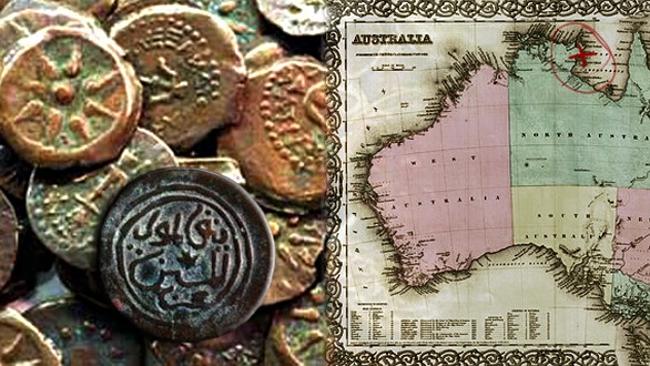
6. Papuans also cultivated sago palms (cycads) for their edible parts. And while the various species of bananas and plantains grow wild all over India and Southeast Asia, it now looks like they were first domesticated in Papua New Guinea, so we can thank the Melanesians for bananas, too.
7. I said “a few centuries ago” because the number of languages in use has steadily decreased since about 1800 A.D. Previously, when people migrated to new places, their methods of transportation and communication remained primitive, so the new communities they founded became isolated from older ones, and over time, every community would develop its own dialect, and sometimes its own language. Then with the invention of efficient sailing ships, railroads, and instantaneous communications like the telegraph, Europeans could conquer/settle lands overseas without losing contact with the “old country.” Consequently a few languages like English, Spanish, French, Arabic, and Portuguese came into use on more than one continent, displacing the indigenous languages spoken previously. Today half of the world’s languages are considered endangered languages, because together they are in use by only 0.2 percent of the world’s population (a total of 13 million), and are likely to disappear in the upcoming century if efforts are not made to preserve them and teach them to younger generations.
8. Today Papua New Guinea has three official languages: English, Tok Pisin (an English-based pidgin language), and Hiri Motu (an Austronesian-based pidgin language). In number of users the Papuan languages range from Western Dani, which has 180,000 speakers in western New Guinea, to languages that may only have fifty speakers. Many of the latter have never been described or put down in written form. One organization doing something about this is the Wycliffe mission; their ultimate goal is to translate the Bible into every language used in today’s world by 2025. On three occasions the author met Victor Schlatter, a retired Wycliffe translator who spent three decades doing this work in Papua New Guinea.
The westernmost Papuan language was Tambora, spoken on the Indonesian island of Sumbawa (between Lombok and Flores). Tambora went out of use not because its speakers switched to another tongue, but because they were suddenly wiped out in a natural disaster. In 1815 the local volcano, Mt. Tambora, exploded; this was the greatest eruption in modern history, and it spewed so much ash into the atmosphere that it temporarily cooled the world, making 1816 the “year without a summer.” Within a few years Tambora was a dead language, and only one list of Tamboran words was collected before the eruption. The present-day inhabitants of Sumbawa speak an Austronesian language.
9. When the tribes in the New Guinea highlands first met Europeans, they thought these were the ghosts of their dead ancestors returning to the community (compare this with the Hawaiian reaction in Chapter 2, footnote #12). Some modern-day Papuans jokingly say the same thing about white tourists.
10. I remember when Pope John Paul II visited Papua New Guinea, the crowd that came to see him carried signs that said, “Me laikum you, Pop!” (pidgin for “I like you, Pope!”), and “Don’t worry, we won’t eat you.”
11. The Australoids who settled the Southeast Asian islands before everyone else, the Negritos, were too few and too primitive to resist the newcomers, and thus were only able to survive in remote locations.
12. It now appears that at least once, Austronesians sailed from Indonesia to the north coast of Australia. However, they did not stick around, presumably for the same reason the first European visitors did not like the place (see the next chapter) – northern Australia is a barren, uninviting land. The reason why we think the Austronesians went there is because the dingo, the wild dog of Australia, looks like it is descended from dog breeds native to Asia. The current theory about the dingo’s origin is that the Austronesians brought them as pets, and when they made landfall in Australia, a few of their dogs ran away. The new environment proved favorable for them, and some became companions of the Aborigines. However, their impact was also destructive; we now believe that some of the Australian animals that became extinct over the past few thousand years were victims of dingoes. This included Australia’s last marsupial carnivores, the Tasmanian devil and the thylacine (also called the Tasmanian wolf or tiger), which in terms of diet and hunting ability, were less flexible than the dingo. The devil became extinct on the Australian mainland around 1600, but survived to our time on Tasmania; that's what makes it Tasmanian. The thylacine wasn't so lucky; it fell victim to disease and humans who saw them as pests, and the last one died in captivity in 1936. The fact that the dingo never got to Tasmania tells us they must have arrived in Australia after the submergence of the ice age land bridges.
In 1996 Tasmanian devils started coming down with a peculiar infectious cancer, that could be spread by bites. The cancer caused ugly tumors to spread across the devil's face, and usually killed the victim in six months. Over the next twenty years, the devil population fell 85 percent as a result. It looked like the devil was about to become extinct even on Tasmania, but recent DNA tests have shown that the surviving animals have at least seven genes that make them immune, so don't write off this species yet.
13. Rats were also introduced to the islands of Remote Oceania, but they probably came as stowaways on the canoes, rather than being brought on purpose.
14. We do not know why the easternmost Austronesians abandoned pottery; some of the islands they discovered did have clay, so we can’t blame it on a clay shortage. Whatever the reason, it wasn’t much of a hardship, because they still made baskets, and they could get pots by trading with islands where the communities continued to do ceramic work, like Fiji.
15. In geologic terms the Polynesians had reached the edge of the Australian plate, and if they had continued they would have passed over the trenches and submerged volcanoes that characterize the Pacific plate. Patrick Marshall, an early twentieth-century geologist, gave the name “andesite line” to the Pacific plate’s borders.
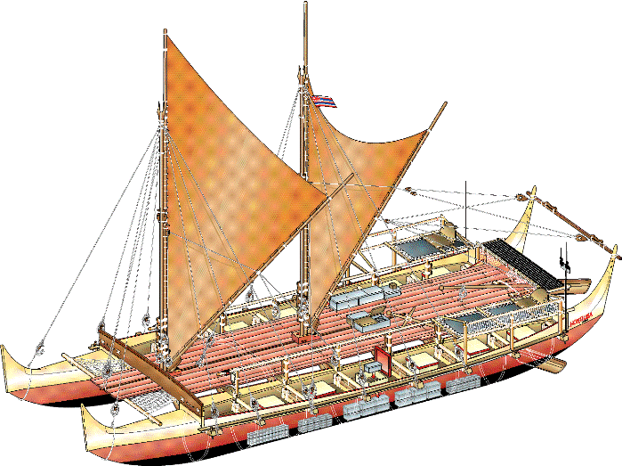
17. Thor Heyerdahl (1914-2002), a Norwegian adventurer, proposed an alternate theory, that Easter Island was colonized by Indians from South America. To make his point, in 1947 he built a balsa-log raft, the Kon-Tiki, and sailed it from Callao, Peru to the Raroia atoll in the Tuamotu Islands, a distance of 4,300 miles in 101 days. While the voyage made him famous, it didn’t prove his theory; it just proved that South Americans could have traveled on the open sea, rather than stick to their own coast, as we know they did most of the time. Later, Heyerdahl admitted he had no evidence that the Easter Islanders were anything but full-blooded Polynesians.
Even so, there are tantalizing clues pointing to a few rafts carrying people to Easter Island, when the local winds and currents took them away from the mainland. Or the Easter Islanders could have taken the initiative, sailed to Chile or Peru, and brought back a few South Americans. At least one stone wall on the island has Inca-style masonry, and the sweet potato, a plant native to Central and South America, can be found here. Also significant, the Peruvian name for the sweet potato (kumar) is so similar to the Polynesian names for it (kumara, kumala, umala, 'uala, etc.), that one is tempted to believe that somebody transported sweet potatoes from South America to Easter Island; later the Polynesians picked them up and took them back to the other islands they had settled. Some isolationists have asserted that sweet potato seeds or tubers could have floated across the Pacific by themselves, but nobody has proven they could survive such a trip.
Most intriguing are the results of DNA tests. The first study, in 2011, identified a few Native American genes in Easter Islanders. A follow-up study, conducted two years later, classified the DNA of present-day Rapa Nui (indigenous Easter Islanders) as 75 percent Polynesian, 15 percent European and 10 percent Native American. The European DNA is a recent addition, from the nineteenth century onward, while the Native American DNA appears to have been added 19-23 generations ago, or between 1300 and 1500. Finally, a 2014 study looked at two ancient skulls from the Botocudo, an Indian tribe living in Brazil, and declared they were were genetically 100 percent Polynesian, suggesting that somebody from Polynesia not only made it to South America, but also traveled more than halfway across the continent to the Atlantic coast. Therefore, it looks like Heyerdahl has been vindicated posthumously.
18. The point in the oceans farthest from land, like Easter Island, is in the South Pacific. Located at latitude 48.52° S., longitude 123.23° W., it is called the Oceanic Pole of Inaccessibility -- Point Nemo for short. This puts it 1,756 miles due southwest of Easter Island. When H. P. Lovecraft wrote his best-known horror story, The Call of Cthulhu, he picked this part of the ocean as the location for R’lyeh, his sunken alien city.
Because of its remote location, Point Nemo is the target rocket scientists aim for, when they have a satellite or abandoned spacecraft in a decaying orbit, and it's too big to completely burn up when it enters the earth's atmosphere. That way, if they succeed in controlling its descent, the object will not fall on anybody. The area 2,500 miles east of New Zealand is sometimes called the spacecraft cemetery for that reason. As of 2015, 161 Russian, European and Japanese satellites have crashed into this part of the Pacific, of which the largest is Mir, the Soviet space station.
However, America's first space station, Skylab, fell to earth in 1979, before the folks at NASA had learned how to steer it on the way down. At the time they could predict when it would crash, but not where, so around the world there was nail-biting anticipation for several days before it happened. In the end Skylab broke up over the ocean south of Australia, and several sizeable chunks hit the town of Esperance, in Western Australia. Luckily no one was hurt, but US President Jimmy Carter felt bad enough about the incident to send an apology to Australia. Esperance in turn fined the United States $400 for littering; a California disk jockey paid the fine in 2009.
19. However, the lack of diseases also meant the Polynesians never had a chance to build up much immunity, making them very susceptible to the diseases the Europeans introduced later (see Chapter 2, footnote #13, and all of Chapter 3).
20. The southernmost island in the Mariana chain is Guam. The United States took Guam from Spain in 1898, and acquired the rest of the Marianas after World War II, almost fifty years later. For several years it was uncertain whether the people living in the latter islands would stay with the US or choose to become an independent state (they voted to stay), so they have always been administered as a separate unit from Guam; we call the chain the Northern Mariana Islands when Guam is left out.
21. Micronesian navigators added one technique to those used by Polynesian navigators: stick charts. These were crude maps made of sticks in a square frame, with other sticks going across the middle to show the paths of important ocean currents and swells. To indicate islands, shells were stuck to the sticks.
22. In all three regions there were varieties of group or individual use-rights under the control or stewardship of community leaders.
23. I found lists of Tu’i Tongan kings on more than one website which gave the names of each king, and the accomplishments of several of them. One of those sites is Wikipedia, and none of them have anything but oral histories to back up this information. So if you want to look up these stories, keep in mind that an oral history is as good as the paper it is written on.
24. After all, in our own time we have heard the territory where a corporation did business referred to as an “empire.” Along that line, will future archaeologists think that a Coca-Cola empire existed in the twentieth century, when they find Coke bottles and cans in many places around the world?
25. ["Pacific voyaging after the exploration period"], Neich, R. 2006 in K.R. Howe (ed.) Vaka Moana, voyages of the ancestors: the discovery and settlement of the Pacific: 198-245. Auckland: David Bateman, pg. 230.
26. By the mid-twentieth century, there was only one toromiro tree left. It has since gone to the Happy Hunting Grounds, but the species has been propagated in botanical gardens.
27. A 2012 census put the population at 5,761, of which 60 percent is native Rapa Nui (see also footnote #17).
28. While we are on the subject of birds, New Zealand has two unusual parrot species. The kakapo weighs too much to fly and is critically endangered, making it both the world’s heaviest and rarest parrot. This hilarious video shows another reason why kakapos are in trouble – the males don’t know what the females look like! Meanwhile the kea, a resident of South Island’s mountains, is also threatened, but is hanging in there because it can fly and is uncommonly intelligent; however, it has become a pest because it uses its brains to attack sheep and destroy the property of humans. One kea made headlines in 2009 by stealing a Scottish tourist’s passport! Who says you have to be human to commit identity theft?
29. "The dodo never had a chance. He seems to have been invented for the sole purpose of becoming extinct and that was all he was good for."--Will Cuppy, How To Become Extinct. See also this footnote from my African history.
30. Australia and New Guinea are also home to a flightless bird you should avoid, the cassowary (see above). Unlike most of the other birds mentioned on this page, it can fight back – and it will. They are as big as people, able to run at thirty-one miles per hour, and have nasty six-inch claws on their feet, making them the world’s most dangerous bird. While there is only one report of a cassowary killing somebody, take my advice and don’t provoke one; they’re probably the closest thing to velociraptors you will ever meet!
31. By the time they were done spreading out, there were fifty-one Maori tribes on various parts of North Island, and four tribes on the less hospitable South Island.
32. After 1500 the Maori practiced cannibalism as well. In present-day New Zealand the subject is understandably controversial, with some dismissing all reports of cannibalism as lies spread by Europeans to justify their exploitation of the islands later on. It should not surprise the reader that the Maori took to eating their neighbors, since we already saw some other South Pacific cultures do it. However, anthropologists believe this horrid practice was done either as an act of “post-battle rage,” or to gain the mana or courage of a slain enemy; warriors did not eat human flesh simply because they were hungry.
33. Today the Maori make up sixteen percent of New Zealand’s population, and you can’t escape their influence. To start with, the country’s five largest cities (Auckland, Wellington, Christchurch, Hamilton and Dunedin) have European names, but most of the smaller towns and geographic features use Maori names.
34. Population figures for a time and place where nobody can read have to be pure guesswork. Our guess for the South Pacific around 500 A.D. is one million people in the entire region. If you want to break it down by ethnic group, that would be 300,000 Australoids, 500,000 Papuans, 150,000 other Melanesians, and perhaps 50,000 for the Micronesians and Polynesians combined. For a group as small as the Polynesians were, they certainly made a lot of headlines! Meanwhile, their Austronesian ancestors most likely numbered 3 million in Southeast Asia. As for the American “Indians,” we estimate that at this time there were between six and seven million of them, in all of North and South America. In other words, the Native Americans would have outnumbered the Polynesians by roughly 130 to 1. The American population would at least double by the time Europeans discovered the New World, one millennium later.
35. It looks like the Polynesians expanded a bit to the west at this time, and settled some small islands in the Melanesian zone. This wasn’t an example of exploration and discovery like we have seen already; the Polynesians were simply staking their claim to islands the Melanesians either hadn’t discovered yet, or didn't want for themselves.
Support this site!
![]()
PAGE NAVIGATOR
A History of the South Pacific
|
Other History Papers |
Beyond History
|