 | The Xenophile Historian |

 |
 |
 |
 |
 |
The Anglo-American Adventure
Chapter 1: Native America, Part I
Before 1607
This chapter is divided into two parts, which cover the following topics:
Part I
Part II
| America's Forgotten History | |
| The Tribes That Met the White Man First | |
| Fish Stories | |
| The Conquistadors Who Drew the Map of North America | |
| The Seven Cities of Gold | |
| Cartier's Misadventures | |
| The Cross and the Sword: Charlesfort | |
| The Cross and the Sword: Fort Caroline | |
| Santa Elena | |
| The Chesapeake Mission | |
| The Ultimate Corsair | |
| The Search for a Northwest Passage (continued) | |
| The Lost Colony | |
| Epilogue |
Introduction
The two largest nations in North America, Canada and the United States, are the marvel and envy of today's world. By Old World standards, they are quite young; the official birth date for the United States is July 4, 1776 A.D., while Canada's is even more recent: July 1, 1867. Most world history texts will tell you the span of recorded history stretches about 5,000 years, and neither country has been around for even 5 percent of that time. Therefore you might think there isn't much of a story to tell here. In that sense, the author is treading on a bit of unfamiliar ground by writing this. Telling American history won't be like writing about the Middle East, for instance, where it took six and a half chapters just to get to 1 A.D.
If you have read any other history papers on this website, you know I am used to looking at the big picture. For my papers covering ancient and medieval history, I have not had much to say about America, because it had no impact on the rest of the world in those days. After Europe discovered America, it remained much the same story until about 1850 A.D.; the only countries affected much by America were those western European nations that had colonies on the other side of the Atlantic. Nor did Americans give the rest of the world much attention until they had tamed their own continent. Since that time, however, America has usually dominated Western civilization. The United States became an industrial giant in the nineteenth century, and in the twentieth century it transformed its industrial power into military, financial, and cultural power. Today the United States is the last remaining superpower from the twentieth century, and with the citizens of other countries watching American movies, listening to American songs, eating at American-style fast food places, and wearing American fashions, it seems that much, if not all of the world, is within the American sphere of influence. Talk about an iron fist in a velvet glove; few empires have imposed their will as thoroughly as the United States is doing today, nor did so many people willingly accept it; in most cases the Americans did it without firing a shot!
The story of how America went from being an unknown frontier to a world leader may not be as long as the stories of the Roman, Egyptian, or Chinese civilizations, but it isn't boring, and (so far) it has a happier ending. First of all, it is because North America has been richly blessed with all manner of natural resources. Resources by themselves are not enough to ensure a nation's success--some places with abundant resources (e.g., Africa and Russia) aren't doing well today, while Switzerland and Japan show us that you can be resource-poor and still do well--but you have to admit they help a lot! The other critical factor is the mind-set of the people; can they use their resources responsibly, to benefit as many people as possible, rather than let the ruling class keep the goodies for themselves? With the United States and Canada, the answer is yes, and that has put both of them in the G-7 group, the exclusive club for the world's richest nations.
This brings us to one more factor that makes Anglo-America unique, and it may be the most important one; the United States and Canada are both social experiments on a grand scale (hence the title of this work). Because of the time lag involved with communicating with a government across the ocean, Americans got used to governing themselves in day-to-day affairs long before they declared independence, with little interference from the Crown or Parliament. After independence came, only a representative government would do for them, and since then Americans have been known for cherishing their freedom, though only after World War II did they try introducing American-style governments to the rest of the world. Also along that line, Americans have been a bolder than average sort; they are unwilling to follow tradition for its own sake, they look to explore where no one has gone before, and they tend to have an optimistic view of the future. Unlike Europe and the Middle East, they don't see their best days as being in the past. It's a similar story with Canada, because Canada was the first former British colony to achieve Dominion status, becoming independent without breaking its ties with the mother country, thereby setting the example for all colonies that London has turned loose since then.(1)
So far I have been talking mostly about the United States. It seems to be a national sin for Americans to take Canadians for granted, ignoring them most of the time; alas, I've done it myself. Throughout its history, Canada has lived in the shadow of its boisterous southern neighbor. Because of Canada's harsher climate, Americans outnumber Canadians by 10 to 1, so there aren't as many events to report on the north side of the 49th parallel. Yet in the name of fairness I will try to give Canada equal time in this work. To any outside observer, Canada should not have survived as an independent nation, and when the United States was expanding, many Americans expected that some day Canada would join them by default. Instead, Canada not only survived but also prospered, and the story of how it succeeded will be covered in the last chapter, after I am done with the United States.
![]()
It Began With the Ice Age
If you have read other papers on this site, especially "The Genesis Chronicles," you know I take a creationist view of our world's origins. Except for "Nebraska Man," and a few wild theories which asserted that the Garden of Eden was in America, nobody has seriously suggested that the human race got started in the New World; if they had, we wouldn't call it the "New World."(2) Therefore everybody who lives in the Americas today, even the so-called "Native Americans," has ancestors who came over from the Old World. However, at the time when we believe the first Americans arrived, the world was in the grip of the ice age; as much as a third of the earth's surface was covered with ice, piled more than two miles deep in some places.
The ice age affected both the north and south polar regions, but in the north the bulk of the ice formed on North America. If you draw a circle around the part of the northern hemisphere covered, the epicenter would be in the Arctic Ocean, between Ellesmere and Devon Islands (two of Canada's northernmost islands) and Thule Air Force Base on Greenland. This is only a few hundred miles from the twentieth-century location of the north magnetic pole, and since magnetic poles don't stay in one place like the geographic poles, the epicenter could be right on the ancient location of the north magnetic pole, for all we know. Apparently the formation of the ice age glaciers was controlled by the earth's magnetic field, through a process that is not clear to us. What is means for this narrative is that at their height, the glaciers covered nearly all of Canada, and the northeastern portion of the continental United States; in Illinois and Virginia they stretched as far south as latitude 37o, more than half way to the equator. By contrast, on the other side of the Arctic, Siberia was largely ice-free, which is amazing when you consider that today Siberia is colder than Europe or North America.
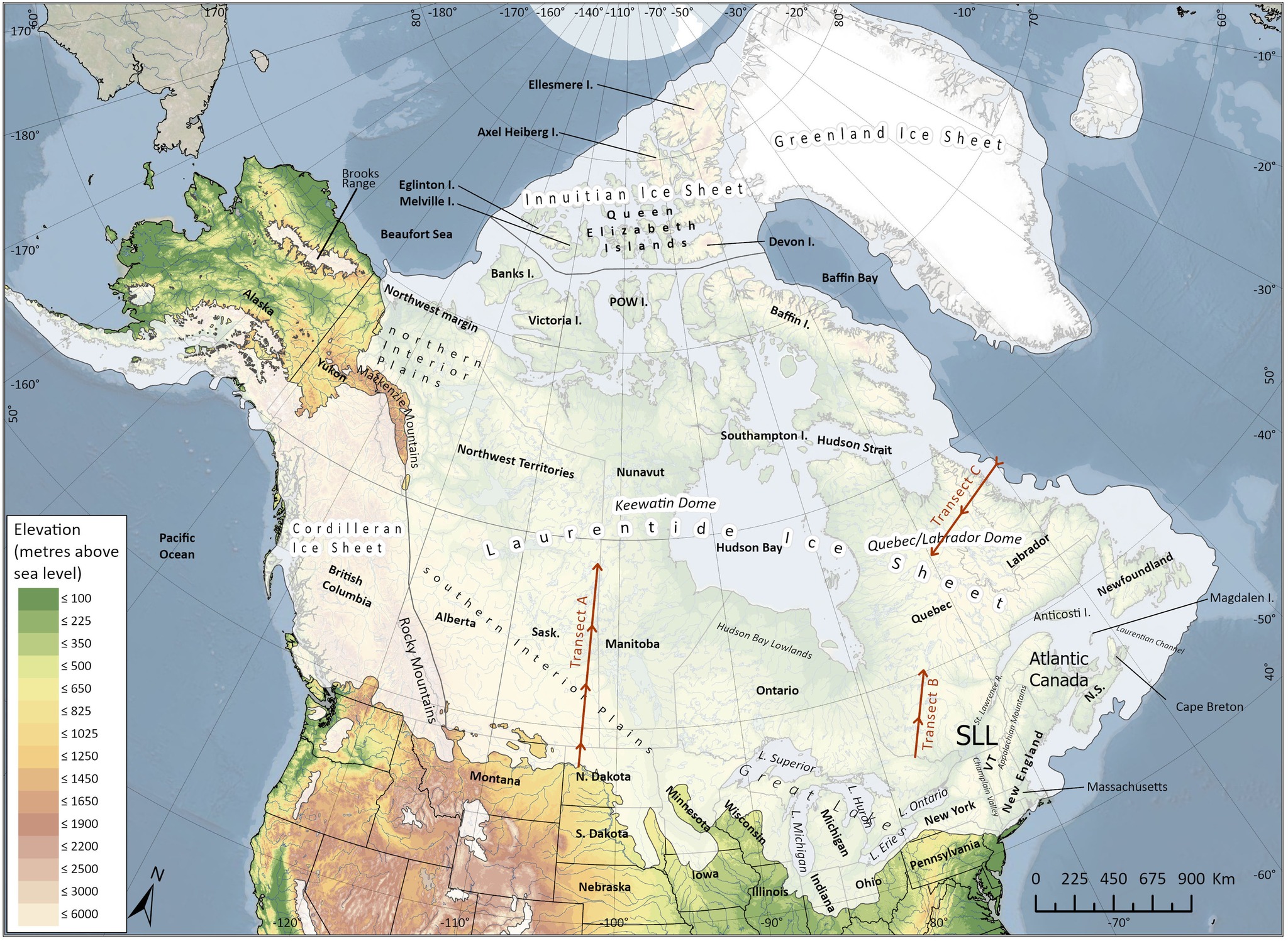
The ice sheets on North America during the ice age. Personally I think the ice got closer to the Ohio River than is shown here; it might have even reached Cincinnati's location. This map is a thumbnail; click on it to open the map full size in a separate window.
Other geographical changes were caused by the drop of world sea levels by more than 300 feet, as a result of so much water from the seas being frozen. The Atlantic and Gulf coasts of North America have a wide continental shelf, so the continent's eastern shore would have been much farther out than it is today, an average of 50 miles in most places. Being a peninsula, Florida was affected the most of all; it was twice as wide in those days, with Tampa Bay near the middle of the state, instead of on the west coast. On the other hand, the Pacific coast wouldn't have changed much; it is on a geologic fault line, part of the Pacific "ring of fire," and thus it has a narrow continental shelf and a relatively steep slope into the trenches of the Pacific Ocean.
Finally, a cooler climate meant slower evaporation, so existing lakes were often much larger than they are today. As a result, geologists give them different names until they reached their current dimensions: Great Salt Lake was part of Lake Bonneville, Lake Tahoe used to be Lake Lahontan, Lake Ontario was once Lake Iroquois, and Lake Agassiz, a veritable fresh-water sea in the middle of Canada, shrank after the earth warmed up to become Lake Winnipeg. Other lakes formed because their outlets were blocked by the ice; an example of this was Lake Missoula in western Montana, which existed as long as glaciers in the Rockies kept water in the area from draining out via the Columbia River.
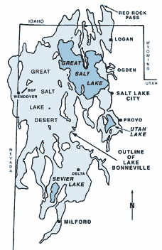
Lake Bonneville, superimposed on a map of modern Utah.
An artist's conception of how Lake Missoula might have looked.
Among the lakes, there is one special case, in the Cascade mountains of present-day Oregon. Thousands of years ago, a volcano that geologists call Mount Mazama blew its top off, in a titanic explosion. We don't know if anyone was nearby to see that awesome blast. Afterwards, the hole left behind filled up with water to become what we now call Crater Lake. At 1,949 feet deep, it is the deepest lake in the United States. It is also one of the clearest lakes; you can see at least one hundred feet down into its waters. And there is a full-sized tree trunk, called "the Old Man of the Lake," floating in the water; the fact that this tree trunk hasn't decayed in a hundred years shows how clean the water is. The waters of Crater Lake are clean because the only sources for the water are rain and melting snow (no rivers flow into or out of the lake), and because the land around the lake has been a national park since 1902. Normally the park is only fully open from July to October, due to weather conditions in the neighborhood.
So how did ice age man arrive in North America? There is general agreement that the first Americans were ex-Siberians; today their closest Old World relatives, from a genetic standpoint, live in the Altai mountains, the spot in northern Asia where Siberia, Mongolia, China and Kazakhstan meet. During the ice age, the lowered sea levels would have produced a land bridge between Siberia and Alaska ("Beringia"), and most believe that as large animals like mammoths, horses, camels and bison traveled across the bridge, tribes of Siberian hunters followed them, and they eventually ended up on the American side when the ice melted and the land bridge was submerged again. However, this theory has some problems. The main one is that even after those Siberians made it to Alaska, they would have been blocked from entering the rest of the Americas by the ice. When the ice did melt, the main glacial mass would have split in two just east of the Rockies, forming a narrow corridor through Canada to the Great Plains; then the rest of the ice melted later. Supposedly the First Americans could have migrated out of Alaska by following that corridor, but since the land would have been a subarctic tundra at the time, it doesn't appear that it would have supported enough grasses, mosses, flowers and other plants to feed those big ice age beasts, meaning that both men and animals would have starved if they tried going all the way down that path.(3) The other problem is that some of the skulls recently discovered, like the famous Kennewick Man, don't look very Asian; one found in Brazil even looks Australoid, though no one knows how the Aborigines would have crossed the Pacific (we have no evidence that they ever built any boats fancier than a raft or dugout canoe.).
It now appears that the first Americans came to the New World in several waves, and at least one of them did not start from Siberia. The latest theory, based on comparative DNA studies, suggests that the first Americans came over in three or four groups, which had no more than seventy people between them. The ancestors of most of the tribes throughout the Americas would have arrived in the first group. The second group would have been the Na-Dene or Athabascans (also spelled Athapaskans), a group of related tribes found mostly in Alaska and western Canada, plus a few tribes in the western United States (e.g., the Apaches). The Eskimos(4) came over with the third group, and while they have done a marvelous job of surviving in an environment that would have killed off anybody else, the game they pursued (mostly fish and seals, later on they learned to add the occasional whale) forced them to stay in the coast lands of the far north; they never even tried to settle more temperate places. If there were any non-Asiatic Indians, they may have come in a tiny fourth group, perhaps by following the edge of the northern icecap across the half-frozen Atlantic from Europe.(5)
In regards to the ice barrier in Alaska, I will propose an alternative way past it. The ocean currents in the northern Pacific move in a clockwise direction that closely follows the Asian and North American coasts, from Japan to California. A boat in that current would have gone to North America with little or no effort; we have reports from the nineteenth century of disabled Chinese and Japanese ships drifting to the west coast of the United States and Canada. Therefore I believe that while the ancestors of the Na-Dene and Inuit may have come directly across the Bering Strait/Beringia, the ancestors of the main Indian group would have traveled by sea, made landfall in California, and stayed there for several generations, increasing in numbers, before moving into other parts of the Americas. On this journey they would not have even been out of sight of land for long, if they followed the Aleutian islands. The only tricky part would have involved dodging icebergs, which form off the coast of Alaska, and any other place where glaciers touched the ocean. Recently it was pointed out that the Chumash, a tribe that lived on the California coast near Santa Barbara, had seagoing vessels almost identical to the outrigger canoes of the Polynesians; maybe this is the connection we're looking for.
The ethnographic distribution of the Indians seems to back up my theory of a sea migration. If you look at a map of native language groups in North America, you will see a few widespread groups like the Algonquians, the Iroquoians, and the Muskogeans in the east, while in the west there are far more tribes and languages. In fact, the distribution of tribes in California is too complicated to show on maps that cover the whole United States. This makes sense if California was the first home in America for most Indians; after they split into tribes, many of them would have stayed in California while the most adventurous among them went east. For a political example of the same process, just look at a map of Anglo-America; because Europeans settled the east first, and went west later, we have fifteen states and five provinces on the east coast, but only four states (five if you count Hawaii) and one province along the Pacific.
![]()
"Five Hundred Nations"
As the ice age ended, North America assumed its present-day appearance. Glaciers melted, lakes shrank, and shorelines receded. The northern part of the continent also started to rise; there had been so much ice on top of it that the weight of the ice had actually pressed the land down, so its removal caused a slight uplift in elevation, through a process called isostatic rebound. This helps to explain the complicated geography of the Great Lakes region. The lakes themselves had been carved out by the glaciers when they originally moved south, and after the ice melted, the land around the lakes was able to drain off in two directions for a while: south into the Mississippi River, and east into the St. Lawrence River. Today the St. Lawrence still serves as the main outlet of the Great Lakes, but the connection to the Mississippi disappeared around 2000 B.C., when the rising land cut off the Illinois River, so that it no longer flowed out of Lake Michigan.(6) As the ice retreated, it left behind a myriad of lakes that still exist today. In fact 62 percent of the world's lakes are within the borders of Canada.
Within a few centuries of the earth's warming up, mammoths and most of the other big game animals of the ice age became extinct. Man probably hastened their extinction by hunting them. We know how they did it, because throughout North America they left distinctive large spear heads, called Clovis points; for that reason, we refer to Paleo-Indian sites containing these spear heads as belonging to the Clovis culture. Recently (2024) it was estimated that for the Clovis people, mammoth meat made up as much as 40 percent of their diet. Once the largest animals were gone, they switched to hunting buffalo, caribou or moose if they could get them, or smaller game like deer, bear, turtles, fish and birds. For most of these they used a spear with a smaller head than the Clovis point, called a Folsom point (hence the Folsom culture), sometimes combined with a hook-shaped stick called an atlatl, which, when placed on the back of a spear before throwing, increased its range and penetrating power. They also supplemented their diet with whatever nuts, berries and seeds they could gather.
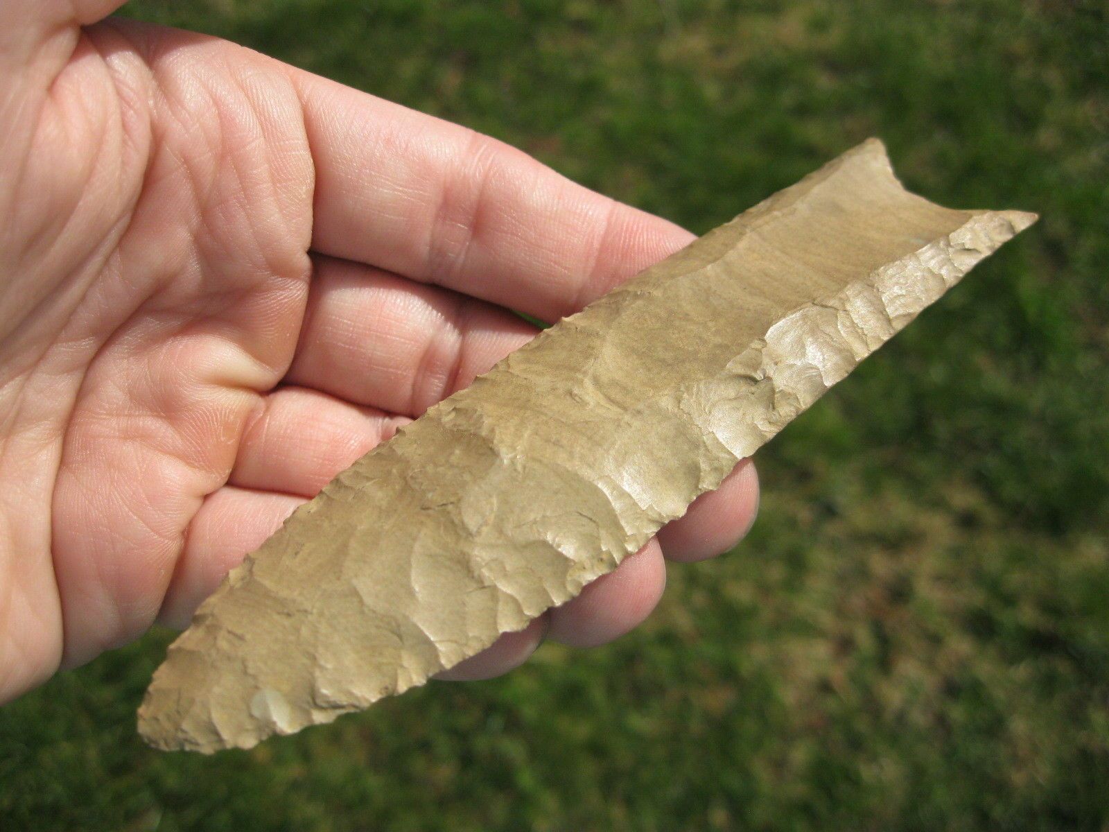
A typical Clovis point. Note the groove that makes fastening it to a wooden shaft easier.
Usually organized into bands of 25 to 75 individuals, the Paleo-Indians spread out from their base sites in the west as their numbers permitted them to do so. By 1000 B.C. they had settled every part of North America, and maybe South America as well. The story of how they explored and colonized the western hemisphere must have been an extraordinary one; too bad nobody was able to write it down for us. Every few hundred miles, they encountered a new ecological zone. They had to learn which plants and animals were safe for food and medicine, and which ones could harm or kill them--and no other people were around to teach them, so many mistakes must have been made in the process. Finally, they had to explore as much territory as possible, to find the sources of food, water and materials for making tools, and to locate potential hazards, including other groups of people, so most of the land must have been scouted out, long before it was occupied.
Because of the different climates, the Indians developed different techniques to survive in every new home they found. This led to the development of different lifestyles, and then different cultures, and finally different tribes and different languages. On the Great Plains, for example, they had to be constantly on the move to keep up with their game (mainly buffalo), so they retained the highly mobile lifestyle which must have characterized most Indians in the early years, using the tepee, an easily dismantled tent, as their shelter. By contrast, the tribes that settled in the forests east of the Mississippi could find plenty of food in one spot, so they were able to build more or less permanent houses of wood. Permanent houses also went up in the desert southwest, though here the building material was adobe (a form of clay), and this region was better suited for gardening than for hunting, so when the Paleo-Indians living here learned how to grow plants, the stuff they used to gather went from being a supplement to their staple. On the Pacific Northwest coast the tribes had an abundant supply of seafood--so much, in fact, that here you could see something hardly ever seen elsewhere--fat Indians.(7)
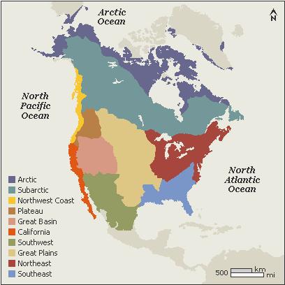
The climatic zones of North America. The Indian tribes in each zone spoke similar languages and had similar customs, but were quite different from the tribes in other zones.
One special characteristic of the Indians, brought about because of their division by climate, is that they have never been united in their history. Sometimes a tribe might be called a nation, but it was never clear what Indians or Europeans meant by the term; an Indian "nation" could be a single family, several families organized into a band, or even a widespread confederacy like that of the Iroquois, which in its heyday occupied much of the land that would later become the state of New York. In addition, individual groups of Indians could break up, disappear, or merge into larger groups, so the total number of "nations" must have changed constantly. Around 1700, French and English settlers estimated that there were fifty or sixty Indian "nations" in the east, while the Spaniards counted fifty more in the west. Native Americans themselves are not sure how many tribes or nations exist, and sometimes they use the phrase "five hundred nations" as a carry-all term to include all of them. The US federal government recognizes 566 tribes, so "five hundred nations" isn't far from the mark.
2014 update: Want to see maps of North America as Native Americans see it? Aaron Carapella has created maps which show the location of each tribe, and use the names by which the tribes called themselves, rather than the better-known names others have given them (names from others can be uncomplimentary, as this footnote from the next chapter demonstrates). Click here to visit Mr. Carapella's website, and here for a news story on his work.
![]()
The Mound Builders
For a long time the tribes in the east were very widely dispersed. Often they lived in single-family homesteads; in addition to hunting and gathering, they grew garden plots of squash, gourds, sunflowers, marsh elder, and lambs-quarters. Some of them knew how to make pottery, but since the potter's wheel had not yet been invented, they rolled strings of clay and put them on top of one another to make the desired shape.
These Indians built artificial hills for various reasons. The earliest mounds, known as middens, were simply trash heaps: piles of shells, bones, ashes and broken pots that accumulated when people lived in the same spot for many years. Then between 1700 and 700 B.C., the Indians of northeast Louisiana began building mounds for other purposes. The largest of these new mounds, at Poverty Point, LA, was shaped like a bird, rising 70 feet high and between 700 and 800 feet wide. Also at Poverty Point were six concentric rows of earthen ridges surrounding a large plaza, and five smaller conical mounds. Nobody knows what these mounds were for; they may have been used for some forgotten religious rite.
Suddenly around 600 B.C., the Indians of the Ohio River valley developed a more sophisticated culture. Called the Adena culture, from one of their sites, they began building mounds that were as much as twenty feet high; these hills were shaped in various polygons (circles, squares, pentagons, etc.), and used as graves for important people. This means that the population in and around Ohio, like that of Louisiana, had grown large enough to engage in big projects. However, the population density per square mile was still quite low, so each mound must have serviced a considerable area.(8)
As time went on, Adena graves grew more elaborate. Tribal leaders were buried in log-lined tombs, while others continued to be buried in shaft graves, or simply cremated. The bodies of the elite were sprinkled with ocher or graphite to give them a lifelike color. Some were buried with bracelets, amulets, ritual axe heads, stone pipes(9), slate tablets, animal decorations made from sheets of mica, and an occasional extra skull (a war trophy?). The mounds also got larger, because new graves would be put on top of the old ones. The most spectacular mound of all had no graves in it, and may have been strictly a place of worship. This was the Serpent Mound, a quarter-mile-long hill in Ohio that was made to look like a snake swallowing an egg.
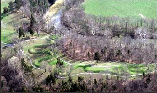
The Serpent Mound.
The Adena peaked around 100 B.C., and then declined rapidly; by 1 A.D. they had disappeared altogether. This was due to competition from a new culture that arose in the Ohio valley in the same century. Called the Hopewell, after another ceremonial site, the newcomers would outdo the Adena in mound-building. Their cemetery compounds included open plazas hundreds of yards across, with roads than ran for miles from the sites. Also, the monuments were not confined to Ohio and surrounding states; Hopewell mounds were also built throughout the Mississippi valley, and as far east as Lake Ontario. And the grave goods buried in those mounds suggest that an extraordinary amount of commerce took place, because they included offerings like obsidian and a grizzly bear tooth from Wyoming, silver from Ontario, copper from Lake Superior, mica from North Carolina, chalcedony from North Dakota, conch shells from the Gulf coast, and turtle shells and alligator skulls from Florida. In other words, they had a trade network that covered nearly all of the eastern United States and the nearest parts of Canada. Because communications were limited to messages that could be transmitted by runners and smoke signals, we do not believe a single tribe or government dominated this huge area; it is more likely that the tribe responsible for building the first Hopewell mounds succeeded in spreading its religion and burial customs to the other tribes it traded with.
In return for all the items that came in from other places, the Hopewell exported chert, a stone very similar to flint that was ideal for making tools, weapons and pipes. The latter were artistic masterpieces, carved realistically to look like various animals, sometimes with eyes and teeth made of inlaid bone or pearl. They also improved on the pottery that had been made in Adena times, sometimes made figurines that showed young women in daily life, and were better farmers than the Adena had been. However, there still weren't very many of them; a Hopewell village might contain just one or two thatch-roofed houses, that were home for a few families. As a result, today's scholars don't understand how either the Adena or the Hopewell got enough people together to build the mounds and clear the land surrounding them.
The Hopewell faded away much like the Adena; after a high point in the fourth century A.D., they went into their own decline. We see poor-quality grave goods going into the mounds from 400 A.D. onward, and after 500 no more burial mounds were built, just a few more hills in the shape of animals. The usual culprits of famine, epidemics and war have been nominated, but we don't have enough evidence to point to any of them; it may have been something as simple as an economic collapse, caused by the trade network breaking down. In 2005 the author came to believe in the 535 A.D. catastrophe theory, which proposes that a natural disaster in that year, like a huge volcanic eruption or a meteor strike, changed world climates for the worse and made life miserable for everyone; perhaps this finished off the Hopewell. In eastern North America, a dark age of sorts followed until 800 A.D., as the population readjusted and grew to reach the critical mass necessary for the rise of the next culture. During this period, somebody in North America invented the bow and arrow. Because an arrow can travel three times as far as a thrown spear, this replaced the spear, becoming the weapon that has been associated with Indians ever since.
The culture that arose in the ninth century was quite different from both the Adena and the Hopewell. For a start, it was not based in the Ohio River valley but in the area where the Missouri and Ohio Rivers merge with the Mississippi, so we call this culture the Mississippian. Second, it raised new mounds on a more ambitious scale than had been attempted before, huge earthen pyramids all up and down the Mississippi valley, and in several locations throughout the southeast. The latter include Owl Creek in eastern Mississippi; Moundville in Alabama; Etowah, Rock Eagle, Ocmulgee, Lamar and Kolomoki in Georgia; Lake Jackson in the Florida Panhandle; and Town Creek in North Carolina.
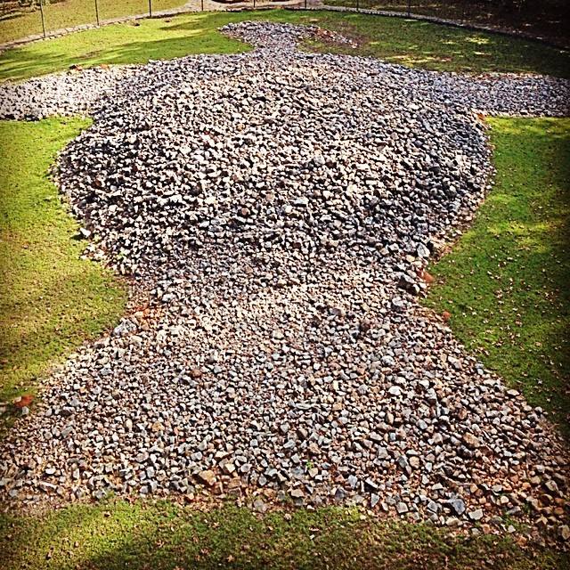
Rock Eagle, near the town of Eatonton, Georgia. Made by piling up quartzite rocks, the central part of the mound is eight to ten feet high. To see the eagle shape, you have to climb a three-story observation tower, next to the mound. My family visited more than once in the 1970s, while on summer vacations. This photo was taken by my daughter, in 2014.
These mounds were used to glorify the living as well as honor the dead; meeting lodges, temples and the homes of chiefs were often placed on top. As for the burial mounds, they contained more artwork of excellent quality; in addition to the usual animal motifs, there were pictures and figurines of people, done with astonishing realism. Finally, the Mississippians were the first tribe north of Mexico that grew corn on a large scale (corn, also called maize, had been a minor crop to the Hopewell). By growing corn with beans, squash and pumpkins, the Mississippians were able to feed five people per square mile, compared with the one person per square mile that had been fed in the days of hunting, foraging, and part-time gardening. A population boom must have resulted, forcing the Mississippians to expand outward and take more land from their neighbors. They also went to war looking for victims; Mississippian art sometimes features warriors holding the heads of defeated enemies as trophies, and we believe some of the bones in the burial mounds came from servants sacrificed at funerals, killed so they could serve their masters in the next life.(10)
The Mississippians were strongly centralized, with a hierarchy that does not appear to have existed among their predecessors. Their most important community--indeed, you can call it their capital--was Cahokia, Illinois (modern East St. Louis). Around 900 A.D. they began building an enormous ceremonial complex here, which eventually numbered 85 mounds, with the central ones surrounded by a wooden stockade. The largest mound of all, Monks Mound, covered 16 acres and stood 100 feet high. At Cahokia's peak, around 1100 A.D., it was home to as many as 20,000 people. When the French explored the Mississippi valley in the late seventeenth century, the presence of Cahokia's mounds encouraged them to found St. Louis on the opposite bank of the river, and even today St. Louis is sometimes called the "Mound City" because of those earthen works.
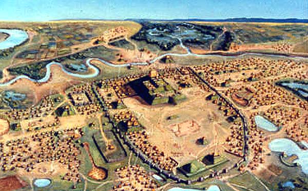
A bird's-eye view of Cahokia in its heyday.
Construction on Cahokia's mounds stopped in the twelfth century, and then it was the Mississippian culture's turn to wither away. The decline started at Cahokia itself, which was abandoned between 1300 and 1500; we don't know whether the cause was overpopulation, warfare, disease, famine, climate change, one of the Mississippi River's notorious floods--or a combination of those factors. Around the same time there was a general migration of tribes eastward, from the central river valleys to the Appalachian mountains and beyond. Thus, we now believe that the tribes that built the mounds did not become extinct, but survived in different places, under different names. According to this theory, the Iroquois and the Cherokee are descendants of the Hopewell culture, while the Mississippian mound-builders became southeastern tribes like the Choctaw and Creek. And in some places mounds continued to be built until the Europeans arrived, though the resulting culture shock, combined with exposure to the white man's diseases,(11) hit the Mississippians like a ton of bricks, and made sure they would not recover.
When Hernando de Soto went on his expedition through the future states of the southeastern US, there were violent clashes with the Mississippian tribes he met, and Old World diseases decimated the tribes he did not meet; more about all this later in this chapter. Probably the last remnant of the powerful Mississippian authority was among the Natchez tribe, in the modern state of Mississippi. French explorers in the early eighteenth century reported that the Natchez chief, known as the Great Sun, lived in a house on top of a mound, while most of the tribe lived in seven villages nearby. The Great Sun had absolute power over everyone; servants carried him everywhere, so that his feet never touched bare earth, and his relatives had to crawl before him, though they were called Lesser Suns and held the highest ranks among the warriors and the priesthood. Below them in the hierarchy came nobles, and then "honored men" (war heroes, artisans and traders), and finally most of the commoners and slaves were at the bottom, called "stinkers" in the Natchez language. If members of two different social classes got married, the individual from the lower class was not promoted, but any children they might have automatically became members of the higher class. Sometimes an ambitious individual could win special treatment by offering a wife, son or daughter as a sacrifice. Human sacrifices also took place when the Great Sun or one of the Lesser Suns died; then their wives, concubines, and a few male advisors and servants would be strangled and buried with them. Later on, when US citizens arrived to settle in the areas containing mounds, they couldn't believe that Indians had built them, and speculated that an advanced, pre-Indian culture was responsible. It took an examination of several mounds and the artifacts they contained in the late nineteenth century, to confirm that they were indeed Native American products.
![]()
The Cliff Dwellers
We noted earlier that the Indians in the southwest depended on whatever food they could grow, because there wasn't as much game to hunt as in other areas. However, from our point of view their situation was also a blessing. In Chapter 12 of The Genesis Chronicles I described how a desert with a steady supply of water, like a river, can be an ideal environment for civilization to develop. Thus, it is probably no coincidence that the Indians of the southwest had a more sophisticated culture, and a more advanced social organization, than most of the tribes found elsewhere. Moreover, the same conditions that made life difficult in the southwest also preserved more artifacts for us to study.
Whereas the mound-building cultures followed one after another in a series, each of the cultures in the southwest got started around the same time, 200 A.D. These were three farming communities: the Hohokam, in the Gila valley of southern Arizona; the Mogollon, in the mountains of New Mexico; and the Anasazi, in the mesas and canyons of the Four Corners region (where Arizona, New Mexico, Utah and Colorado meet). Apparently they were far more peaceful and egalitarian than the Mississippians; no evidence has been found of warfare between the tribes, or of a social hierarchy like the one that characterized the mound builders in their latter days.
Using only pointed sticks, the Hohokam dug ditches and built dams until they had an efficient irrigation system, which made the most of their limited water supply. This allowed them to plant two corn crops every year, and they also grew beans and squash. Around 500, cotton, another plant from Mexico, was added to their list of crops. Between harvests, or during seasons when the crops didn't do well, they would go into the desert to gather cactus fruit, mesquite seed pods, and plants like rhubarb, wild mustard and pigweed, or hunt jack rabbits, muskrats, birds, mule deer, pronghorn antelope, and bighorn sheep. When not busy getting food, the Hohokam painted fine pottery(12), performed ritual dances on adobe platforms, and played the same ball game that was so popular among the Maya in Central America. This game took place in a ball court that had two large rings fastened onto sloping walls. The ball was a hard rubber sphere, made from the sap of a local plant called guayule. The rules resembled modern-day soccer, in that the object was to make the ball go through one of the rings, but not by hitting it with hands or feet, so the players had to use their elbows, hips and knees. Goals were so uncommon that when a player succeeded in getting one, he could claim the clothing of the spectators; the good news is that the Hohokam didn't sacrifice the losing team after a game, as the Maya sometimes did.
Living in the mountains, the Mogollon had less land suitable for farming, but more edible plants and animals in the neighborhood, so they preferred to do hunting and gathering; sometimes they traded with the Hohokam for corn and beans. Because this lifestyle didn't feed as many people, the Mogollon communities were small, usually with no more than a dozen small houses. Houses were made by digging a pit that was 10-16 feet wide and 3-5 feet deep, and giving it wooden walls and roof of mud, branches and thatch. One house was typically larger than the others, and used as a meeting place, where the men smoked pipes, played a game with wooden dice, prepared themselves for ceremonies, and made things like tools, traps, bone flutes, baskets and black-and-white pottery. After 700, the Mogollon expanded southwards, establishing communities in the Mexican states of Chihuahua and Sonora.
In the long run, the Anasazi had the most impressive achievements of all. We are not sure where they came from originally; the word Anasazi comes from today's Navajo, and it means "old ones." However, they apparently arrived on the Colorado Plateau after the other two cultures arrived in their locations, because they lived by hunting until the fifth or sixth century, when they switched to farming and learned how to make pottery from the Mogollon. They also built Mogollon-style pit houses at first, but here they quickly ran out of space as their families grew, so around 750 they began building their houses completely above ground. This marked the beginning of the pueblos, large, multistory apartment buildings made out of stone and adobe. The original pit-house design was now used to make kivas, circular underground chambers that served as places for ritual dances, the settling of disputes, and the teaching of tribal lore to the children; a typical pueblo had several of them.
The change in architecture may have also been prompted by the arrival of unfriendly neighbors. At some point between 500 and 1000 A.D., several Athabascan tribes migrated south from Canada. A few Athabascans, like the Hupa and Tolowa, went to the Pacific coast and occupied a small area on both sides of the California-Oregon border, while the main body moved into the southern Rockies and settled down in eastern Arizona, New Mexico, west Texas and Chihuahua. Because several tribes were involved, they had several names for themselves, such as Tinneh, Tindi, or Dini, which always meant "the people." The tribe that moved into northeast Arizona became today's Navajo, while the rest are usually called by the name the Zuni tribe gave them--Apache, meaning "enemy." One tribe in Utah, the Paiute, was hit so hard by Apache raids that they abandoned their farms, going back to hunting/gathering. Others moved into the pueblos, figuring that it made sense to gather the population in homes that were more easily defended. This caused several of the pueblos to grow until they housed more than a thousand people.(13)
While facing the Apache challenge, the Anasazi enjoyed their best years. Worldwide, the climate was milder than usual between 800 and 1000 (a similar warming trend in Europe caused the Viking invasions and helped end the Dark Ages), and that allowed bigger crops than ever. An improved irrigation system conserved more water, making it possible to cultivate more land. Turkeys were domesticated, for feathers to use in costumes as well as for food, and they learned how to grow and weave cotton from the Hohokam. As for the pueblos, a dozen were built around Chaco Canyon in northwest New Mexico. Even more impressive were the complexes at Canyon de Chelly in Arizona and Mesa Verde in southwest Colorado, which were built on the sides of cliffs to make them nearly inaccessible. In these cases the buildings resembled fortresses and were wedged into crevices halfway up a cliff side; the only way to get to the buildings was by ladders and some steep paths, which could be nothing more than a precarious series of toeholds. On the flat tops of the canyons these communities were in, the residents grew corn, beans, squash, piñon pines and juniper trees (Mesa Verde is Spanish for "green table"). Clearly defense, and safety in numbers, were first on the minds of the people who build these communities.
A civilization may last longer than a ripe melon, but it is just as mortal. All three of the southwestern desert civilizations began to decline after peaking in the twelfth century. Since a good climate led to the good years, we think a change of climate for the worse (the so-called "little ice age") was responsible for the end of those times. Tree ring data has recorded several years of droughts, stretching from 1276 to 1299; no doubt that made it tougher to make a living. By 1300, both Chaco Canyon and Mesa Verde, as well as the Mogollon settlements in the Mimbres valley, were deserted, becoming the oldest of what people in the western United States call "ghost towns." Apache harassment may have also been a factor; it looks like local populations dropped to a point that the Apaches could no longer be kept out of each community, forcing another series of relocations.(14) Still others have suggested that an epidemic from the tropics brought the population down, or that the natives had caused the droughts by cutting down too many trees--a self-inflicted ecological disaster.
The Hohokam were the last to go; their communities appear to have been done in by several years of major river flooding, followed by longer periods when there wasn't enough water. During the dry spells, they reconfigured their canals to capture more water; then around 1355 they were walloped by a catastrophic flood. Between 1355 and 1450, the Hohokam abandoned Casa Grande and their other large settlements, moving into the desert or to more dependable streams. When the Spaniards explored southern Arizona in the late seventeenth century, all they found along the Gila River were villages inhabited by the Pima tribe.
We can't really call the civilizations of the southwest "lost civilizations," because we believe survivors from all of them are with us, though they don't have a record of how they got here. We already mentioned that the Pimas are probably descendants of the Hohokam; there is a general consensus among archaeologists that the Mogollon culture gave rise to the Zuni, and the Anasazi became today's Hopi; other southwestern tribes like the Rio Grande Pueblo and the Papago may also have ancestors from the older cultures. A few years ago one archaeologist, Gary Matlock, wrote that to consider the Anasazi a lost culture "is roughly comparable to viewing those who left England for the New World as having mysteriously disappeared." What he is saying is that the fall of the pueblos isn't really that mysterious, the inhabitants simply packed their bags and left--we only call them "lost" because we don't know exactly where they went. In fact, they don't appear to have gone far, and since the desert southwest was the last part of the United States to be conquered and settled by the white man, today it is the best place to meet Native Americans, as the largest existing tribes are all in this region.
![]()
The March of the Inuit
A bit of elaboration on footnote #4 is in order. Anthropologists use the modern term "Inuit" only for the indigenous culture that has lived in the Arctic for the past few centuries; older cultures in the region are called "Paleo-Eskimo." You will see the reason for the distinction at the end of this section. Anyway, after the Paleo-Eskimos crossed over from Siberia, they were first concentrated around the shores of the Bering Sea. The largest known settlement they had in that area was Ipiutak, at Point Hope in northwest Alaska (occupied 100 B.C.-800 A.D.). When their population grew to the point that they had to expand out from there, they had two choices: they could go south or east. The group that went south became the Aleuts, the dominant ethnic group of the Aleutian Islands, southwest Alaska and the Kamchatka Peninsula. The migration of the eastbound group is more interesting; they settled the northern coasts of Alaska, Canada, and finally Greenland.
When the eastbound group reached the Ungava peninsula (the northernmost part of Quebec), some of them went down the Atlantic coast, instead of continuing across the Davis Strait to Greenland. However, there weren't enough of them to displace the Indian tribes already there, the Innu (in Labrador) and the Beothuk (on Newfoundland). By 500 A.D. they got as far south as Port aux Choix in Newfoundland, but that was only a seasonal hunting camp.
Of course no group of people can go on for thousands of years without making changes in their lifestyle somewhere, and several Eskimo cultures have been identified, based on the artifacts they left behind. When it comes to Paleo-Eskimo cultures, unless you are an anthropologist, only the names, locations and dates need to be remembered. They are as follows:
Saqqaq = Southern Greenland, 2500-800 B.C.
Independence I = Northern Greenland, 2400-1400 B.C. Followed by Independence II, 800-1 B.C.
Groswater = Labrador, 1000-200 B.C.
Dorset = The most widespread Paleo-Eskimo culture, 500 B.C.-1500 A.D. Named after Cape Dorset, on Baffin Island, where artifacts from this culture were first found. The Dorset spread across Canada and Greenland, absorbing all the other Paleo-Eskimos, before they were in turn replaced by the Thule culture. The last members of the Dorset culture were the Sadlermiut tribe, which lived on the islands in Hudson Bay and succumbed to an influenza epidemic in the winter of 1902-03.
At the same time as the Dorset, another culture, the Birnik, existed in northern Alaska (500-1000 A.D.). We believe they were the direct ancestors of the Thule culture, which appeared in the same place around 1000.
The Thule culture is the Eskimo/Inuit culture we are familiar with today. Previous Eskimo cultures did all right in the Arctic, but they lacked a few key elements we now associate with them. To give two examples, they had sleds but not dogs, and they did not have boats larger than kayaks. Now the Thule trained huskies to pull their sleds, and invented a skin boat called an umiak, which could carry as many as twenty men for whale and walrus hunts. In addition, they knew how to use iron, because they maintained contact with iron-using tribes in Siberia, and on the other end of their range, they received some iron tools by trading with the Viking colonies in Greenland.
With these advantages they were able to dominate/absorb all other Eskimo groups. By 1300 they had reached Greenland; by 1500 they had completely replaced the Dorset culture, except for the previously mentioned Sadlermiut.
Apparently the scientists reconstructing the migrations in the Arctic are on the right track, for the Inuit oral history talks about a non-Inuit tribe that lived in the same time and place as the Dorset culture. They call these old ones the Tunit, or Sivullirmiut ("First Inhabitants"). The Tunit are described as being taller and much stronger than the Inuit, and Tunit men could control powerful magic. However, the same stories assert that the Tunit were also gentle giants, shy folks who avoided other people.
The oddest fact about Paleo-Eskimos came from recent DNA tests, comparing the DNA from Dorset/Tunit bones with the DNA of today's Inuit. The DNA samples had nothing in common, except that they all came from humans. DNA studies from other parts of the world show such a combination of genes that we now believe ancient man was quite a frisky fellow; wherever tribes migrated, they had sex with the people they met. (Here is a modern example from Chapter 3.) The presence of a few Neanderthal genes in modern man suggests that even people as radically different as Neanderthals could be bedtime partners for our ancestors. Since Paleo-Eskimos shared no genetic material with the Inuit, it confirms what the Inuit told us; the Tunit really were shy, and when they died out, they left no descendants, only some stone and bone artifacts.
Once their predecessors were gone, the only opponents the Inuit had to face were Europeans, first the Vikings, and later the English and French explorers of Canada. But those are stories for later in this work.
![]()
Who Really Discovered America?
We all hear in school that Christopher Columbus discovered America, but since the western hemisphere was already inhabited when Columbus "sailed the ocean blue," we know that isn't entirely true. If anyone really discovered America, it was the Indians. It is even possible that the Indians discovered Europe; the book "Lies My Teacher Told Me" asserts that two Indian men were shipwrecked in Holland around 60 B.C.
Columbus gets the credit for discovery because he crossed the Atlantic at the height of the Renaissance, in 1492, when Europe was ready to learn about new places, so once he discovered America, America stayed discovered. The same cannot be said for Hwui Shan, St. Brendan, Madog, Leif Ericson, and anyone else who may have crossed the oceans before Columbus did.
Over the years all manner of theories have sprung up concerning people who could have sailed from the Old World before 1492. Candidates for this honor include the Egyptians, the Chinese, the Celts, the Vikings, the Minoans, the Phoenicians, the Basques, or __________ (insert your favorite seagoing culture here). In most cases a few artifacts are cited as evidence for a pre-Columbian crossing. The Phoenician evidence, for example, comes from some Phoenician inscriptions that may have been faked, found in New Mexico and Brazil, while the Negroid appearance of some enormous stone heads carved in Mexico, plus a legend about a king of Mali attempting to sail in the Atlantic, have generated theories about a possible Black African crossing. Others have proposed that North or South America, or an island like Cuba, was the lost continent of Atlantis, and that the transoceanic crossings we should be paying attention to went the other way, from the new World to the Old. For this narrative we will look at the evidence concerning the first four cultures on the above list, because they are the ones most talked about.
![]()
The Egyptians
The ancient Egyptians never had it in them to do much exploring. The conservative rhythm of life in the Nile Valley was good enough for them, and they feared they would miss out on the afterlife if they died abroad, because other countries did not practice the funeral customs they considered so important. What's more, their first boats were not made of wood, but from bundles of papyrus reeds. Nevertheless, some believe that the Egyptians did cross the Atlantic, and they introduced their civilization to the peoples they met on the other side. The similarities between Egyptians and ancient Americans like the Maya and the Incas are obvious even to the untrained eye. Civilizations on both sides of the Atlantic built pyramids, used a system of writing with pictures, were talented astronomers, worshiped the sun and the serpent, performed cranial surgery, and mummified the dead, to name just a few common characteristics. In the 1990s there was also a report of traces of nicotine and cocaine (two drugs derived from New World plants) found in Egyptian mummies, but it wasn't clear if the samples tested had gotten contaminated by modern versions of those drugs.
The Egyptian diffusion theory got a big boost in the late 1960s, when Thor Heyerdahl, the famous Norwegian archaeologist and adventurer, built an Egyptian-style papyrus boat, the Ra I, and launched it from Safi, Morocco. An error in Ra's construction caused it to come apart in the middle of the Atlantic, so Heyerdahl built a second boat, the Ra II, and this one made it to Barbados, the easternmost Caribbean island. Heyerdahl was quick to point out that he had not proven that Egyptians once sailed across the ocean, only that they could have done it if they wanted to. Detractors, on the other hand, claimed that Heyerdahl had proven nothing except that Norwegians are still good sailors!
My own theory is that the similarities between the Egyptian and New World cultures are real, but instead of coming from diffusion, they were caused by both having been descended from an older civilization, namely that of Babel. See what I wrote about the Heliolithic culture, in Chapter 12 of The Genesis Chronicles, for details. I also have a problem with dates that rules out diffusion. Nearly all of the New World structures we call pyramids were built after 1 A.D.; that's more than a thousand years after the Egyptians got tired of building them. This was probably caused by slower progress in the New World, due to three factors: a smaller population to start with, fewer useful animals, and no use of the wheel except as a children's toy. As a result, by 1492 A.D., the New World was at a societal, technological and population level that matched the Old World around 2500 B.C. I also talk more about this in Chapter 12 of The Genesis Chronicles.
![]()
The Chinese
Some Indian tribes, like the Huichol in Mexico, look more than a little Asiatic, and the artwork of Mexican tribes like the Aztecs bears a superficial resemblance to Chinese art from the Shang and early Zhou dynasties (before 770 B.C.).(15) This has led to speculation that the Chinese crossed the Pacific within the span of recorded history. Indeed, China had better ships than Europe until the Portuguese developed the caravel in the fifteenth century, but they only used them to explore for a single generation (1405-33 A.D.) before they lost interest in the whole business.
Is it possible that the Chinese tried exploring at an earlier date, and forgot about it? Several papers, articles and books(16) have discussed Hwui Shan (also spelled Hoei Shin or Huishen), a Buddhist missionary, who claimed to have made the crossing in 458 A.D. According to the story he later told the emperor, Hwui Shan sailed east for 20,000 li (6,000 miles?), found a wonderful land he named Fusang, and preached among the people of Fusang for forty years before returning to China. Fusang's name came from the Fusang tree, a plant that the natives grew for its small, red pear-shaped fruits. A few scholars have tried to identify Fusang with Japan, but Chinese ships had already been going to Japan for some time, at least since the third century A.D. Others have suggested that Fusang was Mexico and the nearest parts of California and Arizona, and that the Fusang plant was either a variety of corn bearing small ears ("strawberry popcorn"), or the prickly pear cactus. Currently this appears to be the most likely explanation. Finally, a few doughnut-shaped stones have been found off the California coast; there's no way to prove it, but some believe these could have been anchors from Chinese ships like Hwui Shan's.
One more Chinese story may be the most amazing of all. Chinese legend reports that around 2250 B.C., China was devastated by a terrible flood. After the country had recovered, Yu, the official in charge of the recovery effort, was sent out on mapping expeditions, to see how the flood might have affected the rest of the world. After Yu returned, he became king of China (the founder of the Xia dynasty, traditional date 2205 B.C.), and his report was preserved as a work called the Shan Hai King. Originally the Shan Hai King had thirty-two books, but only eighteen have survived through the ages, and they have been edited and condensed many times, especially around 200 B.C., when scholars were trying to rewrite the books that had been destroyed in a recent wave of book-burnings. At that time they looked at the Shan Hai King, and failed to find many of the mountains and other places described in it, so they changed its classification from geography to mythology. That was the way things stood until the nineteenth and twentieth centuries, when a few Western scholars took at look at the work. Their conclusion was that the Shan Hai King's author intended it to be a scientific journal, not a collection of made-up stories.
From our point of view, the fourth book of the Shan Hai King, "The Classic of the Eastern Mountains," is the most interesting. It is divided into four sections, each one listing a series of landmarks, usually mountains; it states the distances between the landmarks, and has a detailed description of each, including interesting rocks, plants and animals. One paragraph, for example, describes a sea creature with a man's face that would swim on its back and beat its abdomen (the sea otter), while another describes a funny animal that avoided its enemies by playing dead (an opossum, no doubt!). If there was once an introduction, it no longer exists, so the book gives no information on how to get to the first place in each section.
No mountains in China or any other Asian country match the ones described in the fourth book--but mountains in western North America fit the descriptions. Assuming these descriptions are accurate, the first section began with the Sweetwater River in Wyoming, and went due south along the Rockies, listing these landmarks:
- Medicine Bow Peak (WY)
- Longs Peak (CO)
- Grays Peak (CO)
- Mt. Princeton (CO)
- Blanca Peak (CO)
- North Truches Peak (NM)
- Manzano Peak (NM)
- Sierra Blanca (NM)
- Guadelupe Peak (TX)
- Bald Peak (TX)
- Chinati Peak (TX), in the Big Bend area of the Rio Grande.
- Hart Mountain (MB), near Lake Winnipegosis
- Moose Mountain Provincial Park (SK)
- Sioux Pass (MT), at the junction of the Missouri & Yellowstone Rivers
- Wolf Mountain (WY)
- The Big Horn range (WY)
- Medicine Bow Peak (WY)
- Longs Peak (CO)
- Mt. Harvard (CO)
- Summit Peak (CO)
- Chicoma Peak (NM)
- South Baldy (NM)
- Cook's Peak (NM)
- Madera (Chihuahua, Mexico)
- Pamachic (Chihuahua, Mexico)
- Culiacan (Sinaloa, Mexico)
- Triangulo, near Mazatlan (Sinaloa, Mexico)
- Mt. Fairweather (AK)
- Mt. Burkett & Kate's Needle (AK)
- Prince Rupert (BC)
- Mt. Waddington (BC)
- Mt. Olympus (WA)
- Mt. Hood (OR)
- Mt. Shasta (CA)
- Los Gatos (CA)
- Santa Barbara (CA)
- Mt. Ranier (WA)
- Mt. Hood (OR)
- Bachelor Butte (OR)
- Gearhart Mountain (OR)
- Crane Mountain (OR)
- Mahogany Peak (NV)
- Trident Peak (NV)
- Capitol Peak (NV)
![]()
The Celts
Ireland is the westernmost country in Europe, so many have felt that it shouldn't be difficult for the Irish, or somebody related to them, to cross the Atlantic. Those who believe in a Celtic crossing point to Mystery Hill, a collection of menhirs and artificial caves in New Hampshire. The foremost Celtic advocate, Barry Fell (1917-94), wrote three books about the evidence for a Celtic presence in America, like Roman coins, dolmens and Ogham inscriptions, and used this site as the primary exhibit.(17)
Unfortunately, Mystery Hill can no longer be considered evidence for anything, because the site has been tampered with. Some of the stone structures may have been built by Native Americans before the first European settlers arrived, or by the Pattees, the family that owned the property in the nineteenth century. Then in 1937 an antiquarian named William Goodwin purchased the site, and gave it the name Mystery Hill. Goodwin believed that the structures were built by Irish monks who came to New Hampshire as early as the seventh century, to escape persecution at the hand of the Vikings, and believed this so strongly that he "fixed" parts of the site that did not support his theory (e.g., the coins and inscriptions are likely fake, for that reason). The site was sold again in 1956, subsequently turned into a tourist attraction, and given its present-day name of America's Stonehenge.
Speaking of monks, the next evidence for Celtic contact comes from St. Brendan (circa 486-578?), an Irish monk who really liked to travel. When not building monasteries, he went on journeys across the sea, reportedly visiting the Hebrides, Shetland, Faeroe and Canary Islands, Brittany, Iona, and Scotland. His travels became the subject of a popular medieval romance, The Voyage of Saint Brendan, recounting his fabulous adventures. Influenced by this romance, medieval and early modern mapmakers included a St. Brendan's Island on their maps, between the Antilles and Cape Verde Islands. It also inspired some modern adventurers to build a coracle, a leather-covered boat like the ones the Celts used, to re-enact Brendan's crossing of the Atlantic in 1976. We may never know if Brendan reached America, though; his stories are so garbled and fanciful that nobody knows for sure where he went. He claimed, among other things, that he met "sea cats," giant sheep and talking birds on his journey, and once he made a fire on an island that turned out to be a whale! Most likely the uncharted land he visited was Iceland, for we know that other Irish monks went there from the eighth century onward.
Finally, there is the possibility of a Welsh crossing in the Middle Ages. A librarian named Ellen Pugh believed this happened; in her book Brave His Soul,(18) Pugh proposed that in 1170 a Welsh prince named Madog chose not to get involved in the bloody politics of his homeland, going out to sea instead. Supposedly he made it to Alabama's Mobile Bay, left a few colonists behind, and returned to Wales to get some more. He was never heard from again after his second trip west, and hostile Indians forced the colony to move to the part of the Appalachians where Georgia, North Carolina and Tennessee meet. Later on, Cherokee attacks dislodged the Welsh from this location, too, so they followed the rivers to the Mississippi, and went up the Missouri River until they disappeared. After European settlers crossed the Appalachians, there were occasional reports of Welsh-speaking Indians. This was enough to make Thomas Jefferson, himself of Welsh ancestry, tell Lewis and Clark to keep an eye out for Welsh-speaking Indians when they explored the northern Great Plains. Sure enough, the Mandan tribe of North Dakota reportedly had some members with light-colored hair and fair skin. Unfortunately, the Mandans died out before the white man could learn much about them; a smallpox epidemic killed most of their nation in the 1830s. The few hundred who survived do not look any different from other Indians, and their main claim to history is that they are the only Indian tribe that never fought a war with the United States.
![]()
The Vikings
The Vikings were the best sailors and fiercest warriors of Dark Age Europe, so when they needed new land for their surplus population, it was natural that some would look for it beyond the frontiers of the known world. As a result, Leif Ericson surveyed eastern Canada in 1000 A.D. I already told about Leif's expedition in Chapter 7 of my European history, so I won't repeat the details here. At any rate, the local Indians or Inuit were hostile, and soon the Vikings found that even they could not win a fight when their supply lines stretched all the way across the Atlantic. The last follow-up expedition was led by Thorfinn Karlsefni in 1006, and then the Vikings loaded up their dragon-ships and left.(19) They tried to hold on in Greenland, but as we saw, the Inuit had already arrived there; with both the weather and the Inuit against the Vikings, their Greenland colonies failed by the end of the Middle Ages.
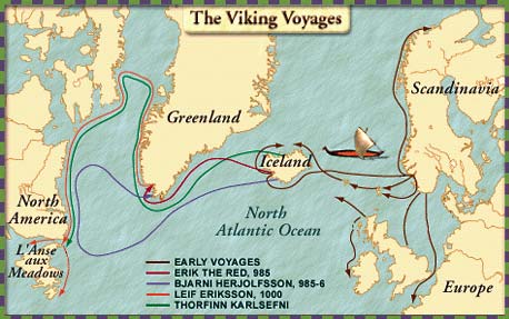
The Viking expeditions.
Unlike the Egyptian, Celtic and Chinese claims, we have solid archaeological evidence that Leif Ericson reached America, in the form of his campsite, found at L'Anse aux Meadows, in northern Newfoundland, in 1960. Still, not everyone is satisfied by this discovery, for Leif called the place he tried to settle Vinland, naming it after the wild grapes that grew there. This suggests a temperate climate, and Newfoundland is barely warm enough to be called temperate (nearby Labrador is downright subarctic). Is it possible he and Karlsefni tried exploring the coast to the south, and if so, how far did they get? Over the years there has been a lot of speculation about other places the Vikings might have visited, with 50 sites, 73 artifacts and 100 inscriptions attributed to them. Probably the most famous site is Newport, Rhode Island, which has a curious 24-foot-high round tower; once thought to be a church built by Christian Vikings, it has since been identified as a seventeenth-century construction. As for the artifacts and inscriptions, many of them, when examined, have turned out to be forgeries, like the Vinland Map and the Kensington Rune Stone. Therefore we are left wondering if Leif Ericson pulled the same trick as his father, Eric the Red, who lured settlers to the ice-covered place he discovered by naming it "Greenland."
Other Europeans did not visit the lands discovered by the Vikings, simply because they never heard about them. The only people who remembered were the Icelanders, and they wrote down Leif Ericson's story in the form of a Norse saga. Thus, Vinland became just another fabulous island in the Atlantic, no more real than Atlantis or King Arthur's Avalon. After that the New World played no part in Old World Affairs, and vice versa, for nearly five hundred years, until other Europeans began to cross the Atlantic.
![]()
How Many Indians?
One subject hotly debated these days is Native American demographics. According to census figures from the year 2020, 3.7 million US citizens identified themselves as "Native Americans," and 1.8 million Canadian citizens declared they were descended from the "First Nations." These numbers include the Inuit and the M�tis (Canadians of mixed Indigenous and European ancestry), for a total of 1.1 percent of Americans, and 5 percent of Canadians. Because of an increased life expectancy, brought about by modern medicine and a rising standard of living, this is probably as high as the population has ever been. But what were the numbers when indigenous peoples had all the land to themselves? The traditional viewpoint is that there were 15 million people in the whole western hemisphere when Columbus arrived. This population would have been evenly divided between North and South America. Of the North American portion, one million lived north of the Rio Grande, half a million on the islands of the Caribbean, and the remaining six million were concentrated in Meso-America (Mexico + the seven nations of Central America). No tribe or nation that we know of ever took a census, so we can only guess at how many Indians really lived at this time, and that guessing is done by looking at how many artifacts they left behind. For that reason, some have argued that America could have supported twice as many Indians, with about the same number of artifacts and no more impact on the environment than what we already see. Furthermore, both the mound-building and the cliff-dwelling cultures had seen their best days long before 1492, so the total population, whatever it was, may have peaked at an earlier date, like 1200 A.D., and then declined after that.
If this was the only issue I wouldn't bother to write about it; scholars, after all, can believe any figure they want. But the debate does not stop there; some have increased the estimated population by one or even two orders of magnitude, meaning they actually believe there could have been more than 100 million Indians in the Americas! Numbers on this scale violate common sense; indeed, Europe's population did not reach the 100-million mark until the mid-seventeenth century. If the New World had that many people, many of them would have been crowded together in big cities. Where are the pre-Columbian equivalents of London and Paris? Mexico had impressive cities like Tenochtitlan, but north of the Rio Grande, the largest communities that we know of were either religious centers like Cahokia, or oversized apartment complexes like Mesa Verde. Could they have been home for thousands? Yes. Millions? No.
In addition to that, we must keep in mind that while North American tribes knew how to grow crops, none of them gave up hunting and fishing. In other history papers I have pointed out that farming the land full-time produces more food than herding, hunting or gathering, and because the Indians lived a lifestyle that was nomadic or semi-agricultural at best, they would have had a hard time feeding everyone if there were more than a few million of them. When European settlers begin to tell us how many Indian neighbors they had, their figures work best with a pre-Columbian population of one or two million.(20)
Of course, those who want the big numbers have an explanation. They will argue that the colonial-era figures are correct because the white man was a filthy slob who brought diseases like smallpox, and they killed off most of the Indians by 1600 (see footnote #11). We know for a fact that a lot of Indians died because they had no immunity to Old World microbes, but the revisionist historians want you to believe in a 90+% mortality rate, to cut the population from 20 million or more to 2 million or less. Alas, there is no record anywhere of an epidemic that virulent. A 2011 study of Native American DNA, using samples from both old bones and living individuals, concluded that the genetic variation seen among today's Indians is best explained by a 50 percent drop in population during the sixteenth century. Therefore, it looks like 50 percent was the most likely mortality rate, for the epidemics caused by first contact. You can compare that with the worst plague in Old World history, the Black Death, which is estimated to have killed anywhere from a third to half of Europe's population. The only part of the Americas where tribes were completely wiped out before 1600 was in the Caribbean, and there the brutality of the Spaniards was also a factor.
What I am trying to say is that it is a politically correct fantasy to claim that Anglo-America once had tens or hundreds of millions of Indians. It's part of the effort to describe pre-Columbian society as a Utopia, where non-white peoples lived in perfect harmony, both with nature(21) and each other. Think of it as another version of Rousseau's "noble savage." Elsewhere you may hear like-minded folks claim that hundreds of millions of Africans perished in the Atlantic from the slave trade, or that thousands of witches fell victim to a series of persecutions called "the burning times"; the same kind of thinking is at work here, promoting multiculturalism by making Western civilization look bad. Finally, there's the guilt that white Americans feel over what their ancestors did to the Indians, and they try to atone by promoting Indian cultures. Unfortunately the truth isn't so attractive. Indian children were as likely to die from diseases as anyone else's children, the various tribes fought frequently, and some of them elevated torture to an art, considering it a good deed if a warrior tortured a captured enemy to give him a chance to prove his courage.(22)
In some of my other works, I used Occam's Razor to decide which side to take; I did it with the creation-evolution controversy, and I did it with ancient Egyptian chronology. This famous maxim has been around since the fourteenth century, when William of Occam declared that the simplest solution which explains all the facts is likely to be the correct one. I am applying Occam's Razor to American populations as well, using his words "It is vain to do with more what can be done with less." Besides, claiming that the evidence for millions of Indians was destroyed by epidemics sounds a little like a classic conspiracy theory. I never was fond of conspiracy theories, which assume that one person or a small group can plan for everything that can possibly go wrong, in this unpredictable world. Somebody once said that a conspiracy theorist is like an undertaker who only has one size of coffins; if he gets a body that doesn't fit, he's going to alter the body, not the coffin.
The original "Department of Homeland Security."
This is the end of Part I. Click here to go to Part II.
FOOTNOTES
1. Despite the clean break, today's Americans feel closer to the United Kingdom than to any other country, because of the common language and culture. A few years ago I heard someone explain this by saying that most European countries can only be allies of the United States, but the British are family! My response is: if you accept this line of thinking, then the Australians are family, too.
2. People may have lived in the western hemisphere before Noah's Flood, but the only evidence of their presence are some out-of-place artifacts ("ooparts").
3. Most ice age animals were larger than their present-day counterparts, because a simple law of physics worked in their favor: large objects don't lose heat as quickly as small ones, due to the reduced surface-to-volume ratio. However, large animals also eat more, so size was less of an advantage when the world warmed up again.
4. "Eskimo" (also spelled Esquimaux) is really a derogatory term, given to them by the nearest Algonquin Indians; it means "raw meat-eaters." Nowadays they prefer to be called Inuit, meaning the "real people." The new name was officially adopted at the Inuit Circumpolar Conference, held in Barrow, Alaska, in 1977. For that reason I may use the term "Eskimo" so that everyone knows who I'm talking about, and then switch to "Inuit" without warning.
5. This is the so-called "Solutrean solution," named after the style of Cro-Magnon artifacts made in Europe at the time of the crossing.
6. Modern engineering restored that connection, in the form of the Illinois and Michigan Canal.
7. The most famous symbol of the Pacific Northwest Indians, the totem pole, is a testimony to how much free time they had for art. However, this was a relatively recent development; they only started carving tree trunks into totem poles in the nineteenth century, when they obtained iron tools from the white man. And see Chapter 7, footnote 9, for another Pacific Northwest custom--potlatching.
8. The sixth century B.C. produced a remarkable number of philosophers and religious leaders in the Old World: Thales, Pythagoras, Jeremiah, Ezekiel, Confucius, Buddha, Zoroaster, etc. In other papers I speculated on a universal spiritual movement causing this to happen. We don't know why the Ohio valley Indians started burying their dead in mounds at this time, but I wouldn't be surprised if a great "medicine man" came along and told them to do it.
9. It is tempting to think that the pipes were used with tobacco, but we don't know if any Indians north of the Caribbean had tobacco this early, or what plant they would have smoked if tobacco wasn't available.
10. Does all this talk about corn, pyramids and human sacrifice sound familiar? Tribes in central Mexico, like the Toltecs, had all of these elements in their civilization, so it is quite possible that the Mississippians were in contact with the Mexicans, and got some ideas from them. If such a cultural transmission took place, it probably involved merchants, missionaries or ambassadors traveling from Mexico along the Gulf coast, until they got to the Mississippi valley. Alternative routes, like an overland march through the middle of Texas, are less likely; that path went through land that was more arid, and thus less inviting, and only the tribes on the eastern frontier of Texas built mounds or practiced any other Mississippian customs.
11. Most Europeans had gotten out of the habit of bathing regularly during the Middle Ages; they stopped going to the public baths of Roman times because they didn't want their belongings stolen while they were in there, and they didn't see any health benefits in keeping clean; afterwards they questioned the morals of those who continued to bathe. As a result, when the white man began exploring the world, he literally came on strong everywhere he went!
12. The Hohokam also developed a technique for etching designs on shells with acid. Europeans didn't learn this trick until the Renaissance.
13. Some of the pueblos built at this time were Taos, Pueblo Bonito, Casa Grande, and the Aztec Ruins. Casa Grande was built on the Gila River, and thus must have been a Hohokam community, whereas the others were Anasazi. All of the above names are modern except for Taos; the "Aztec Ruins" got their name from somebody who thought the Aztecs came from there, and probably have nothing to do with the Mexican Indians by that name.
14. A book published in 1999, Man Corn by Christy Turner II & Jacqueline Turner, looked at evidence of ritual cannibalism at Anasazi sites, especially in Chaco Canyon, and suggested that the Anasazi practiced ritual violence, at least during their latter years. This may be why modern Indians shun Chaco Canyon as a place of bad medicine. Of course the theory is controversial, because it leads us to believe that the Anasazi were not so peaceful after all.
15. A Chinese-American professor, Michael Xu, dropped a bombshell in the 1990s when he announced that he had translated an inscription from the Olmecs, Mexico's oldest civilization, and claimed it was a very old form of Chinese! He brought his Chinese counterpart, Chen Hanping, to the United States, to see the inscription at the Smithsonian, and Chen verified Xu's translation. Unfortunately, there is hardly anyone else in today's world who can read archaic Chinese, so we can't be sure if their interpretation--that the founders of the Olmec kingdom were a group of refugees from Shang dynasty China--is accurate.
16. Mertz, Henriette, Gods From The Far East, New York, Ballantine Books, 1953 (reprinted in 1972).
17. The titles of Mr. Fell's books are America B.C., Saga America, and Bronze Age America. They were published respectively in 1976, 1980, and 1982.
18. New York, Dodd, Mead and Company, 1970.
19. Karlsefni's wife, Gudrid Thorbjarnardottir, became mother to a baby boy named Snorri, the first white child born in the New World. I'm mentioning this for readers who may have heard of Virginia Dare, the baby born in Sir Walter Raleigh's "lost colony" (see the last part of this chapter). The archaeologists who excavated L'Anse aux Meadows found a spindle whorl, a wheel-shaped stone used to turn sheep's hair into wool thread, and that has been cited as proof that Gudrid was not just a myth from a Norse saga; it means women were at the Vinland colony, at least.
Gudrid accomplished much more than just having a baby in Newfoundland, and her story has been almost forgotten, even by historians. Born in Iceland around 962, she went on Eric the Red's voyage that discovered Greenland, because her husband was a member of the crew. However, that husband didn't survive the trip, so she found herself a widow at the age of twenty. Later she remarried, this time to Thorfinn Karlsefni, and this is how she ended up in Vinland. After Karlsefni's death, she went back to Iceland, but eventually got bored there, and though she was now a grandmother, she went on a journey to mainland Europe, going all the way to Rome, though that meant she must have walked most of the way. In Rome she had a meeting with Pope Benedict VIII, and she told him about all the places she had seen; this must have amazed the pope, because most Europeans knew nothing about the lands the Vikings had gone to, across the Atlantic. Then Gudrid returned to Iceland, became a nun, and spent her last years living in an Icelandic church. Thus, the whole story of Gudrid Thorbjarnardottir is another example of how women have been written out of medieval history, and how much more interesting that history could be if they were left in it.
20. On at least one occasion, the Indians tried taking a census of the white man. A few years after Jamestown was founded (see the next chapter), Chief Powhatan sent a member of his tribe, Uttamatomakin, on one of the ships returning to England. Uttamatomakin was given two assignments: find Captain John Smith, who had gone back to England on another ship, and count the number of people in the English "tribe." For the latter task, he got himself a long stick when he arrived at the English port of Plymouth, and made a notch in it every time he saw a new person. He gave up when he reached London.
21. The "harmony with nature" bit was popularized in the 1970s by a famous public service ad, which showed an Indian crying when he paddled his canoe to a riverbank fouled by twentieth-century pollution (actually an Italian actor played the part). However, the first Americans could waste the environment if they wanted to. Before they got horses, for example, the plains Indians hunted buffalo by driving a whole herd over a cliff! The most famous of these stampeding places is Alberta's Head-Smashed-In Buffalo Jump, named for a Blackfoot Indian who was killed when he stood at the base of the cliff to watch the falling buffalo, and was buried under their carcasses. All in all, I would argue that the main reason why the environment stayed intact until the European arrival was because there weren't enough people around to ruin it.
By the way, when somebody says the word "bison" or "buffalo," most of us think of the animal that lives on the Great Plains, but there is a related species, the wood bison, that lived in the forests of North America. Originally they ranged far enough east for eastern tribes like the Iroquois to be familiar with them, and these tribes hunted the wood bison occasionally. Like the plains buffalo, they were hunted to near-extinction by the white man in the nineteenth century (see Chapter 4). In the continental United States, the wood bison was eradicated completely, but a few survived in Alaska and northern Canada, and careful conservation efforts have allowed their population to increase since the 1920s. In Canada, for example, 3,000 wood bison live in Wood Bison National Park, located on the border between Alberta and the Northwest Territories. This park, the largest in Canada, is also one of the two nesting areas of the whooping crane, an extremely rare bird. Most recently, the wood bison has been introduced to Yakutia, Siberia, to replace a bison species that lived there during the ice age.
22. Despite all the benefits that we enjoy from Western civilization, there are always some who nostalgically look back to earlier days. One joke along that line has a reporter interviewing an ancient Indian chief. He says, "Chief, you have observed the white man for almost 100 years. You have observed his wars and his material wealth. You have seen his progress and the damage he has done. Considering all these events, in your opinion, where did the white man go wrong?" The chief replied, "When white man found the land, Indians were running it. No taxes, no debt, plenty buffalo, plenty beaver, woman did all the work, medicine man free, Indian man spent all day hunting and fishing." Then he concluded with a smile, "White man dumb enough to think he could improve system like that."
Support this site!
![]()
PAGE NAVIGATOR
The Anglo-American Adventure
|
Other History Papers |
Beyond History
|